Inspiration
FrostFlow was inspired by the real challenges cities and commuters face every winter. Snowstorms and freezing conditions often turn roads into unpredictable hazards, leading to accidents, delays, and inefficient use of maintenance resources. Despite the scale of the problem, most winter operations still rely on reactive decisions and blanket salting rather than targeted, data-driven strategies.
As a civil engineering student, I was motivated by the opportunity to apply civil and environmental principles to a problem that affects millions of people every year. I wanted to explore how infrastructure data, weather information, and community input could be combined to make winter travel safer while also reducing environmental damage caused by excessive road salt.
I was also inspired by the idea of bridging the gap between maintenance teams and everyday road users. By creating a system that serves both groups simultaneously, I aimed to show how smarter coordination can improve safety, efficiency, and sustainability.
Ultimately, FrostFlow was driven by a simple question: what if winter road management could be proactive, precise, and environmentally responsible instead of reactive and wasteful?
What it does
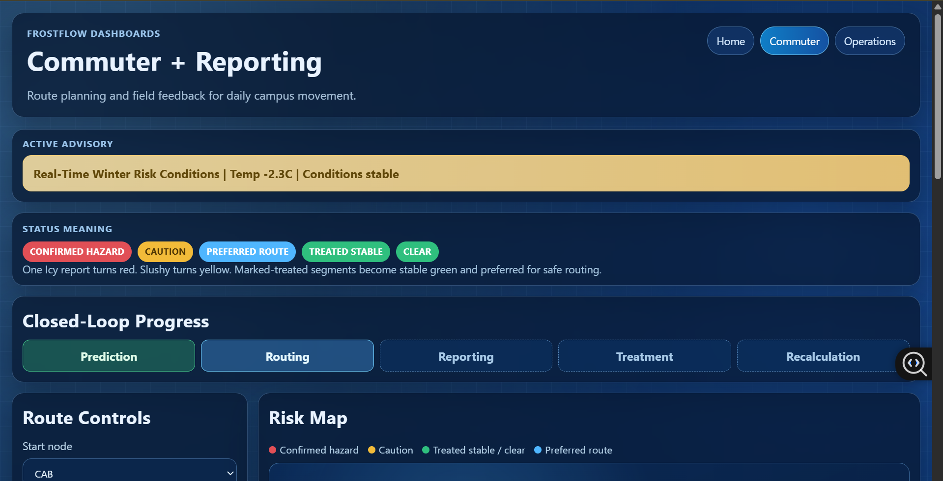
FrostFlow is a smart winter road management and routing system that helps cities, maintenance teams, and commuters stay safe during snow and ice conditions.
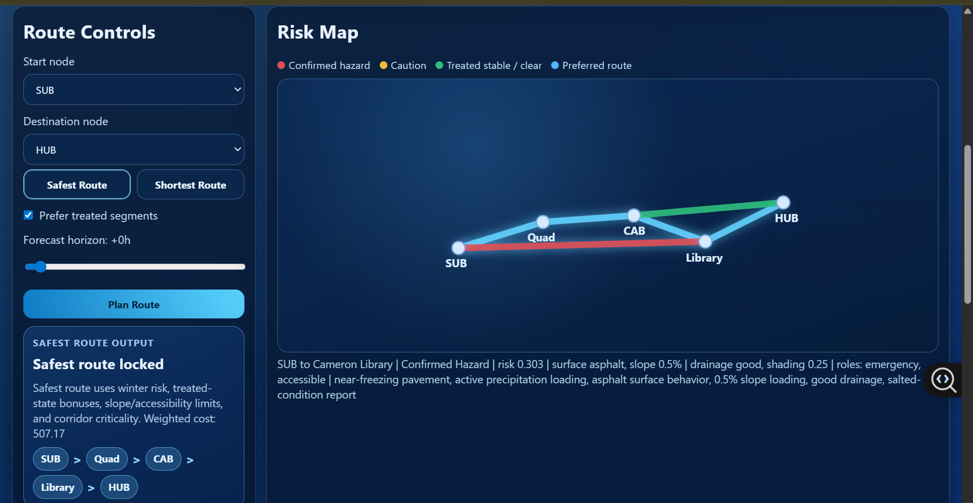
The platform analyzes weather data, road characteristics, and real-time field reports to identify which road segments are most dangerous. It then prioritizes treatment and recommends safer routes that avoid high-risk areas rather than simply choosing the shortest path.
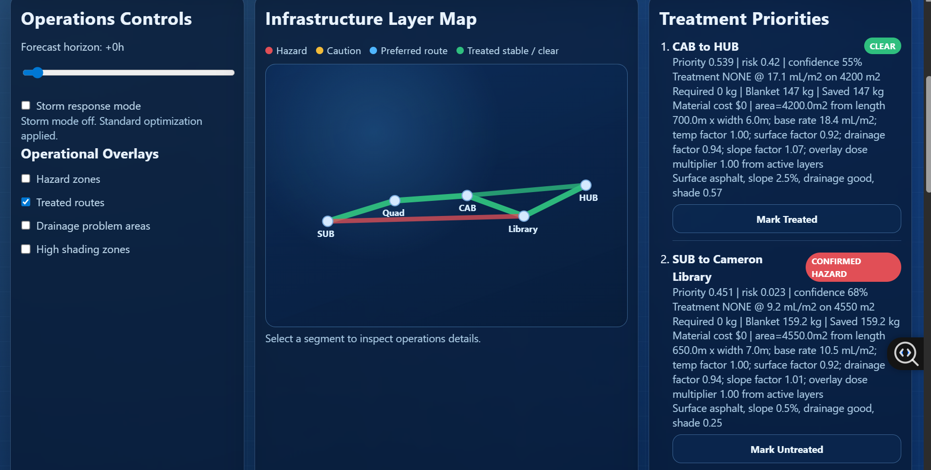
Maintenance teams receive a planning interface that shows where to deploy salt, brine, or sand, how much material is needed, and which locations should be treated first for maximum impact. This enables targeted treatment instead of inefficient blanket salting.
Commuters access a synchronized interface that provides safer navigation during winter storms, accounting for untreated roads, icy segments, and hazardous conditions.
By coordinating treatment planning with risk-aware routing, FrostFlow reduces accidents, saves materials, lowers costs, and minimizes environmental damage from excessive salt use.
The system is designed to support smarter, more sustainable winter operations while improving safety for everyone on the road.
How I built it
I built FrostFlow as a Python + web stack:
- FastAPI backend for risk analysis, routing, reporting, and treatment planning
- Two synchronized web interfaces for commuters and maintenance teams
- Shared state between interfaces to support real-time coordination
Each road segment stores civil engineering attributes such as surface type, slope, drainage quality, shading, and traffic importance. The engine combines these physical characteristics with weather conditions and field reports to assess winter risk.
Engineering model
1) Risk model
For every road segment, FrostFlow computes a risk score between zero and one. The score is built from four components:
- Weather risk based on temperature, precipitation, and freeze-thaw conditions
- Crowd-sourced field reports (for example, icy conditions have higher impact than slushy conditions)
- Physical hazard modifiers such as poor drainage, heavy shading, or known danger areas
- Reduction due to prior treatment (salt, brine, or sand)
These components are combined and then limited to a safe range so the model remains stable.
Routing decisions use a risk-aware cost. Segments that are longer, untreated, or higher risk become more expensive for route planning. This allows FrostFlow to recommend safer paths rather than simply the shortest ones.
2) Treatment planning
For each segment, the system estimates how much material is needed. First, the segment area is computed from its length and width. Then the required application rate is adjusted using civil factors:
- Higher hazard areas receive more material
- Poor drainage increases required dosage
- Shaded areas need additional treatment due to slower melting
The final treatment mass is calculated from the adjusted rate and the segment area. Treatment type is selected based on winter conditions (brine, salt, or sand). Segments that have already been treated are not scheduled again unless conditions worsen.
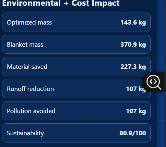
3) Environmental impact
FrostFlow also estimates environmental effects to support sustainable operations. Runoff potential is estimated using drainage and shading characteristics, which influence how much material may enter waterways. The system compares optimized targeted treatment against traditional blanket salting. It calculates how much chloride use is avoided by treating only high-risk segments instead of spreading material everywhere. A sustainability score summarizes:
- Material savings
- Reduction in chloride pollution
- Coverage of high-risk areas
This ensures decisions balance safety, cost, and environmental responsibility.
Challenges we ran into
Contradictory status display (hazard + treated at once). Segments not starting in clear state due to stale reports. Overlay checkboxes initially looked interactive but had no backend effect. Environmental table looked static and sometimes showed unrealistic totals. UI complexity increased after splitting commuter and operations workflows.
Accomplishments that we're proud of
I successfully built a working end-to-end prototype that integrates civil engineering principles, weather risk analysis, and real-time user input into a single coordinated platform.
Also, I developed a risk-aware routing system that prioritizes safety over shortest distance, demonstrating how data-driven decision making can improve winter mobility and implemented targeted treatment planning that estimates material needs based on physical road characteristics, showing a practical alternative to inefficient blanket salting.
Another accomplishment was designing synchronized interfaces for both commuters and maintenance teams, allowing operational decisions and public guidance to stay aligned in real time.
Most importantly, demonstrating that winter road safety, operational efficiency, and environmental sustainability can be addressed together within one system.
What we learned
Through this project, I learned how complex winter road management really is and how many factors must be balanced, including safety, cost, logistics, and environmental impact.
I gained experience combining software engineering with civil and environmental engineering concepts, translating real-world infrastructure problems into computational models. I also learned how to design systems that remain understandable to non-technical users while still being technically rigorous.
Working under hackathon constraints strengthened our ability to prioritize features, iterate quickly, and collaborate effectively.
This project showed us the importance of interdisciplinary thinking when solving real urban challenges.
What's next for FrostFlow: Creating safer, smarter and scenic winter routes
The next goal is to expand FrostFlow into a fully deployable system for municipalities and transportation agencies.
Future improvements include integrating live traffic feeds, higher-resolution weather forecasting, and automated data collection from road sensors and connected vehicles. I also plan to refine the routing engine to consider not only safety but also comfort and scenic value, enabling winter routes that are safer, smoother, and more enjoyable.
Long-term, FrostFlow could support smart city initiatives by helping cities reduce accidents, optimize maintenance resources, and minimize environmental damage from road salt.
I envision FrostFlow evolving into a decision-support platform that transforms how communities prepare for and respond to winter conditions.
Built With
- css
- fastapi
- git/github
- html
- javascript
- python
- render

Log in or sign up for Devpost to join the conversation.