-
-
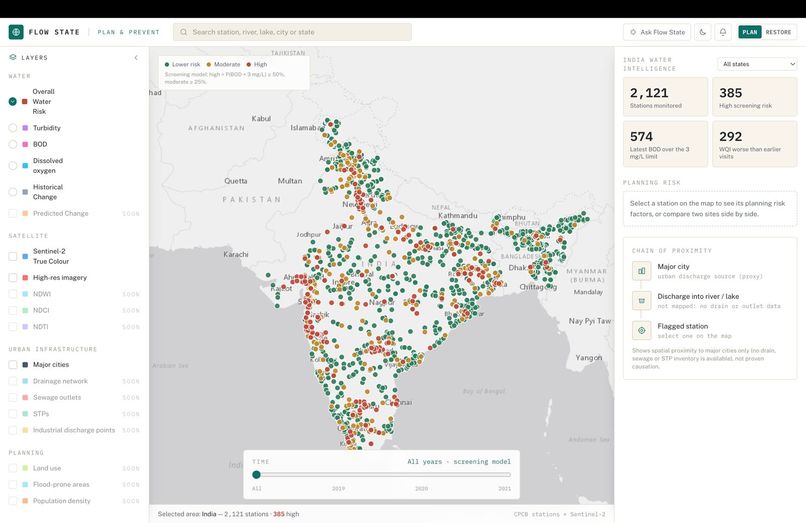
dashboard
Government inspectors physically visit rivers and lakes, dip a bottle in the water, and send it to a lab to measure things like dissolved oxygen and sewage content (BOD). That's accurate, but it only covers ~2,100 spots in India and each spot gets checked a few times a year at most — most of the country's water is never checked.
Satellites photograph the same water bodies every few days, for free, everywhere. The question this project asks is: can a satellite photo tell us which water is polluted, without a physical visit?
The honest answer turned out to be nuanced, and the project is built around that honesty rather than around a sales pitch:
"Give me the exact number" (e.g. "BOD is 4.2 mg/L") — mostly no, unless there's already a monitored station nearby. Sewage and dissolved oxygen don't change the colour of water in a way a camera can reliably pick up; the water's history (what's upstream, whose sewage drains in) matters far more than what it looks like on one day. "Tell me if this spot is probably polluted, so I know where to send an inspector first" — yes, usefully. That's a coarser, easier question, and the satellite answers it right about 3 times out of 4 (AUC ≈ 0.75-0.78) — good enough to turn "check 2,100 random spots" into "check these first." "Give me a number near a spot that's already monitored" — yes, meaningfully better than guessing the average. A distance-weighted blend of nearby stations' known values plus the satellite/context features gets real R² gains (DO 0.02 → 0.42) within tens of kilometres of the existing network, tapering off with distance. So Flow State's real deliverable is a triage tool: a ranked list of which water bodies most likely need a human to go check, built entirely from free satellite images plus government lab data used to teach the model what "polluted" looks like from space. It does not replace lab testing — it tells you where to point it.
Built With
- fastapi
- python
