-

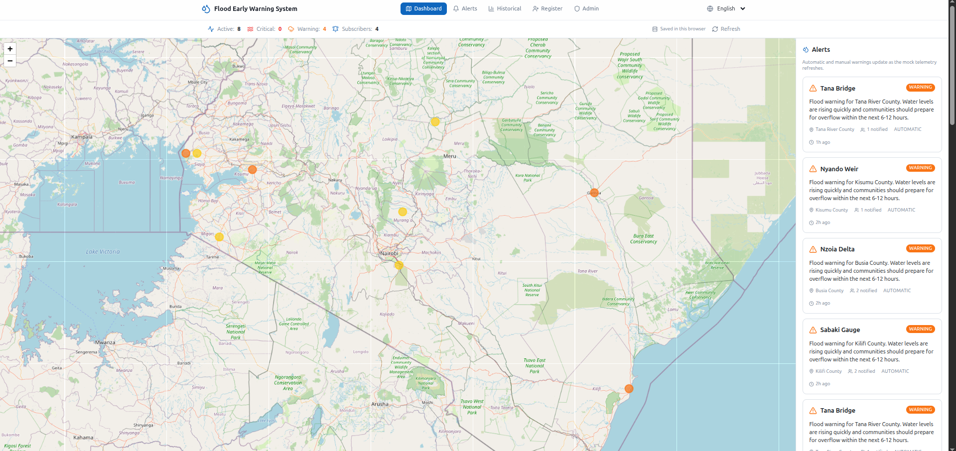
Regional stats
-

Mapview for easy state visualization
Inspiration The inspiration for FloodWatch stems from the recurring, devastating flash floods in Nairobi, Kenya. In recent years, the city has faced increasingly unpredictable weather patterns, leaving residents in informal settlements and low-lying areas like South C, Nairobi West, and Thika Road vulnerable. We realized that while the rain is inevitable, the lack of real-time, localized data and a centralized emergency coordination system was causing unnecessary loss of life and property. We wanted to build a "digital lifeline" for a city that is rapidly growing but struggling with drainage infrastructure.
What it does FloodWatch is an AI-augmented flood management and early warning ecosystem designed for the Nairobi urban context. Its core features include:
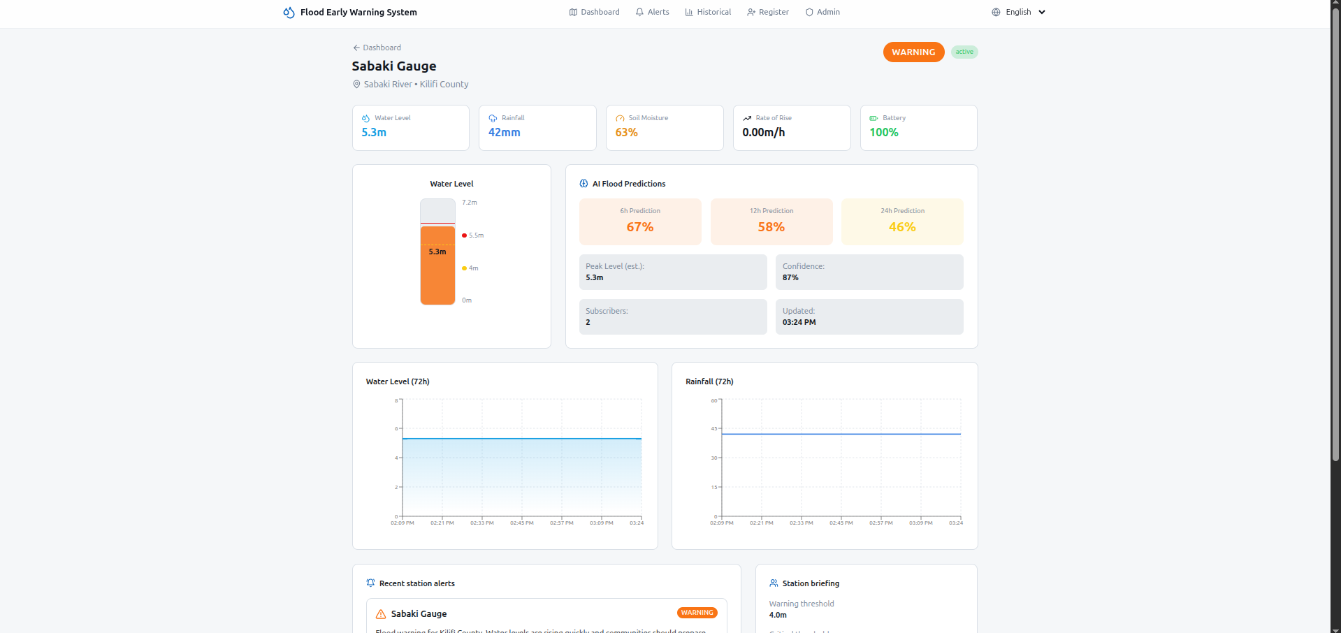
Danger Marking: A real-time, crowdsourced map that identifies "Red Zones" (high water levels) and "Yellow Zones" (rising risks).
AI Predictive Alerting: Moves beyond simple "current level" alerts by using machine learning to predict floods up to 24 hours in advance.
Localized SMS/Push Notifications: Sends geo-fenced alerts to specific wards (e.g., Kibra, Mukuru, or Kasarani) before the water reaches critical levels.
Damage Control & Rescue Coordination: A dashboard for emergency services (Red Cross, Nairobi County Fire) that uses AI to prioritize rescue requests based on predicted flood depth and population density.
How we built it The system uses a multi-layered tech stack designed for high performance and reliability:
Frontend: A lightweight React Native mobile app and a web-based GIS dashboard using Mapbox for high-accuracy terrain mapping.
AI & Machine Learning: We implemented Long Short-Term Memory (LSTM) neural networks to process historical rainfall data from the Kenya Meteorological Department (KMD) alongside real-time sensor inputs to forecast river surges.
Backend: A Node.js environment handling real-time data ingestion from IoT water-level sensors placed near the Ngong and Nairobi Rivers.
Computer Vision: We integrated an AI module that analyzes geotagged photos uploaded by users to instantly verify flood severity and detect trapped individuals.
Challenges we ran into One of the biggest hurdles was data scarcity; historical records for flash floods in informal settlements are often non-existent. To solve this, we used Gemini to scrape and structure years of public news reports and social media data to "teach" our AI what a flood event looks like in Nairobi. We also struggled with sensor durability in high-debris river environments and "data noise" from false crowdsourced reports, which required building an AI-based verification gate.
Accomplishments that we're proud of We are incredibly proud of our low-latency alert system, which successfully demonstrated a notification speed of under 5 seconds from the moment a sensor triggers. Furthermore, our "Safe Route" AI algorithm doesn't just tell people to flee; it analyzes elevation data and real-time "Red Zones" to navigate users through the safest possible paths to high-ground shelters identified by the county.
What we learned Building FloodWatch taught us that technology is only 50% of the solution; the other 50% is community trust. We learned that for an alerting system to work, it must be integrated into existing structures like Nyumba Kumi. Technically, we discovered that AI-driven "Digital Twins" of the city are far more effective at predicting flash floods than traditional static hydrological models, especially in high-density areas with complex drainage.
What's next for FloodWatch Our next step is to expand our Computer Vision capabilities to include drone-based damage assessment, allowing for rapid insurance payouts and government aid. We also plan to release a "Predictive Planning" tool for the Nairobi City County government to help them identify exactly where new drainage infrastructure is most needed based on our AI's flood simulations through 2030.


Log in or sign up for Devpost to join the conversation.