-
-
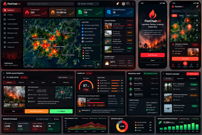
FireChain AI — AI-Powered Peatland Fire Monitoring & Response
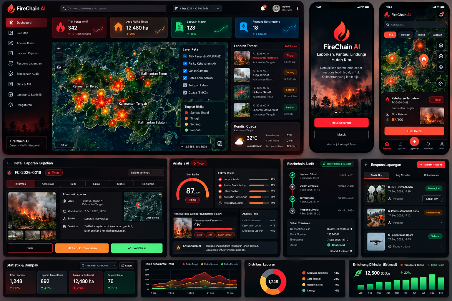
FireChain AI: AI-Powered Peatland Fire Monitoring and Blockchain-Based Environmental Accountability
Inspiration
Indonesia's peatlands, particularly in Kalimantan, are among the world's most important ecosystems for carbon storage, biodiversity conservation, and environmental stability. However, peatland fires continue to threaten these ecosystems, release significant amounts of greenhouse gases, damage habitats, and expose surrounding communities to hazardous haze.
Traditional fire monitoring and response efforts face challenges related to fragmented information, delayed reporting, limited situational awareness, and difficulties maintaining transparent incident records.
We built FireChain AI to address these challenges by combining artificial intelligence, satellite data, geospatial technology, and blockchain into one integrated web application. Our vision is to help stakeholders identify potential fire risks, understand environmental conditions, manage incident reports, and maintain transparent records of response activities.
Rather than treating fire prevention as an isolated monitoring problem, FireChain AI connects environmental intelligence with evidence management and coordinated action.
What it does
FireChain AI is an integrated environmental monitoring platform designed to support peatland fire risk assessment, incident reporting, and transparent response coordination in Kalimantan, Indonesia.
Its core capabilities include:
- Satellite Fire Monitoring: Integrates NASA FIRMS hotspot data to visualize satellite-detected thermal anomalies and help users monitor potentially affected areas.
- AI-Powered Risk Assessment: Uses AI capabilities to analyze available environmental and geospatial information and support the identification of areas requiring further attention.
- Interactive Geospatial Dashboard: Presents hotspot information and incident locations on an interactive map, helping users understand the geographic distribution of potential fire activity.
- Incident Reporting and Evidence Management: Supports the documentation of fire incidents and associated evidence, helping organize information for review and follow-up.
- Blockchain-Based Evidence Auditing: Uses blockchain technology to record evidence hashes and relevant audit events, helping make changes to registered records detectable.
- Incident Tracking and Response Coordination: Brings incident information and status updates into a centralized workflow to improve visibility into reported events and response progress.
- Environmental Data Insights: Helps users explore monitoring information and incident patterns to support more informed environmental decision-making.
By integrating these capabilities, FireChain AI aims to reduce information fragmentation and provide a more transparent workflow from environmental observation to incident documentation and response tracking.
Satellite hotspots and AI-generated assessments are treated as decision-support information, not as definitive confirmation of a fire. Field verification and appropriate human oversight remain essential.
How we built it
We developed FireChain AI as a web application with integrated environmental data, AI-assisted analysis, geospatial visualization, and blockchain-based evidence auditing.
The application brings these components together through a modular architecture designed to support data processing, incident management, and traceable environmental records.
Technology Stack
- Frontend: Next.js, React, TypeScript, and Tailwind CSS for a responsive and interactive web interface.
- Geospatial Visualization: MapLibre for rendering interactive maps, satellite hotspot locations, and incident information.
- Backend and Data Processing: Python and FastAPI for backend services, data processing, and AI integration.
- Satellite Data: NASA FIRMS for accessing satellite-derived fire hotspot information.
- AI Integration: AI-powered analysis to support fire risk assessment and the interpretation of available environmental information.
- Database: PostgreSQL with PostGIS for structured records and geospatial queries.
- Blockchain: Solidity and an EVM-compatible blockchain environment for evidence-hash registration and auditable incident events.
- Deployment Infrastructure: Containerized and cloud-compatible components to support deployment and future scalability.
System Workflow
- Environmental and satellite hotspot data are retrieved and processed for visualization.
- The web application presents geospatial information to help users identify areas that may require attention.
- Integrated AI capabilities support the assessment of potential fire risks using available information.
- Incident reports and supporting evidence are organized for review and follow-up.
- Evidence hashes and relevant audit events are registered on the blockchain to support tamper-evident recordkeeping.
- Incident status and response information are managed through the application to improve traceability and coordination.
The architecture separates raw environmental observations, AI-generated assessments, reported incidents, and blockchain audit records. This distinction helps preserve context and prevents automated outputs from being mistaken for verified ground conditions.
Challenges we ran into
Integrating Different Data Sources
Combining satellite hotspot information, geospatial data, AI analysis, and incident records required a consistent approach to data processing and presentation. Each source has different characteristics, update frequencies, and limitations.
Interpreting Satellite Hotspots
A satellite-detected hotspot does not always indicate a confirmed active fire. Thermal anomalies may have different causes, and observations can be affected by cloud cover, satellite overpass timing, and other factors. Communicating this distinction is important for responsible monitoring.
Making AI Useful and Responsible
AI-generated risk assessments can help prioritize attention, but their usefulness depends on data quality, model validation, and clear communication of uncertainty. We designed the platform as a decision-support tool rather than a replacement for expert judgment or field verification.
Maintaining Trust in Environmental Evidence
Blockchain provides a way to register evidence hashes and track relevant record changes. However, it cannot independently establish whether the original evidence is truthful or accurate. Reliable reporting, verification procedures, and appropriate access controls remain necessary.
Connecting Monitoring with Action
Environmental monitoring becomes more useful when observations can be connected to incident documentation and response workflows. FireChain AI brings these functions into a unified web application to improve visibility and traceability throughout the process.
Accomplishments that we're proud of
We are proud to have developed FireChain AI beyond a standalone visual concept into an integrated web application that brings together several technologies for a real environmental challenge.
Our key accomplishments include:
- Integrating NASA FIRMS satellite hotspot data into an environmental monitoring workflow.
- Combining AI capabilities with geospatial information to support fire risk assessment.
- Developing an interactive web interface for viewing environmental and incident information.
- Integrating blockchain-based evidence auditing to support tamper-evident records.
- Connecting environmental monitoring with incident documentation and response tracking.
- Bringing these capabilities together in a unified platform focused on peatland fire risks in Kalimantan.
These accomplishments demonstrate how AI, satellite-derived data, and blockchain can complement one another when applied to environmental monitoring and accountability.
What we learned
Building FireChain AI reinforced the importance of integrating technologies around a clear operational purpose.
Satellite data provides valuable large-scale observations, but those observations need context and ground verification. AI can help analyze information and prioritize areas for attention, but its outputs must be evaluated carefully and presented with appropriate uncertainty.
We also learned that blockchain is most valuable when used for a specific accountability requirement, such as recording evidence hashes and maintaining an auditable history of relevant changes. It complements evidence verification rather than replacing it.
Another important lesson is that environmental monitoring systems need more than technical integration. Data quality, usability, security, transparency, and collaboration with people who understand local conditions are all essential to making the technology useful.
Ultimately, effective climate technology should help people make better-informed decisions while clearly communicating what the data can—and cannot—prove.
What's next for FireChain AI
Our next goal is to strengthen FireChain AI's reliability and prepare it for broader evaluation and real-world use.
Our roadmap includes:
- Improve AI Validation: Evaluate risk assessment performance using appropriate historical data and documented evaluation metrics.
- Enhance Environmental Data Coverage: Explore additional weather, vegetation, peatland, and other relevant datasets to improve environmental context.
- Strengthen Evidence Verification: Improve incident review workflows, evidence metadata, access controls, and auditability.
- Expand Response Coordination: Refine incident assignment, status tracking, and communication workflows for relevant stakeholders.
- Improve Security and Performance: Conduct systematic testing of application functionality, API security, data integrity, and scalability.
- Collaborate with Local Stakeholders: Seek feedback from environmental researchers, conservation organizations, local communities, and relevant authorities.
- Conduct Controlled Pilot Evaluations: Assess usability and operational value in realistic scenarios before considering deployment for emergency decision-making.
Our long-term vision is to make FireChain AI a reliable and scalable environmental intelligence platform that supports earlier identification of potential fire risks, better-organized incident information, and more transparent environmental response processes.
By connecting AI, satellite monitoring, geospatial analysis, and blockchain-based auditing, FireChain AI aims to contribute to the protection of Indonesia's peatlands and the communities that depend on them.
Built With
- artificialintelligence
- blockchain
- climatetech
- datavisualization
- environmentalmonitoring
- fastapi
- geospatialanalysis
- gis
- machine-learning
- maplibre
- nasafirms
- next.js
- postgis
- postgresql
- python
- react
- satellitedata
- smartcontracts
- solidity
- tailwindcss
- typescript
- web3
- wildfiredetection


Log in or sign up for Devpost to join the conversation.