Inspiration
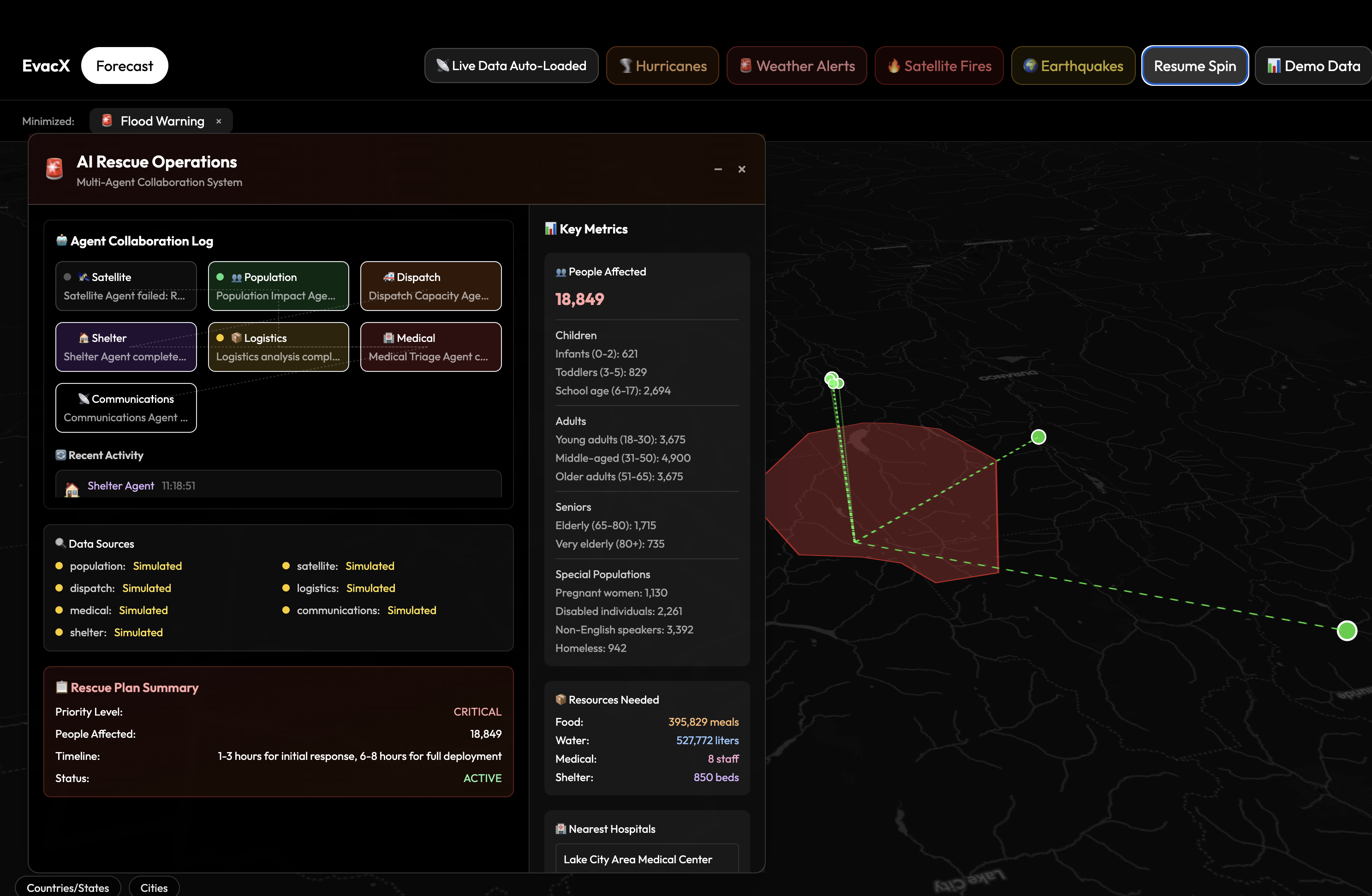
EvacX was inspired by the critical need for advanced disaster response systems that can process massive amounts of real-time data from multiple government agencies and provide actionable intelligence for emergency evacuations. The project addresses the gap between raw satellite data streams and practical evacuation planning by creating an AI-powered system that can analyze, coordinate, and optimize emergency responses in real-time What it does EvacX is a comprehensive AI-powered disaster intelligence and evacuation planning system that: Real-time Data Integration: Aggregates live data from NASA FIRMS (fire detection), NOAA NWS (weather alerts), NHC (hurricane tracking), and USGS (earthquake monitoring) Processes satellite imagery, atmospheric patterns, and geological data streams Provides real-time hazard assessment and risk scoring Multi-Agent AI System: 7 specialized AI agents working in parallel: Satellite, Population Impact, Dispatch Capacity, Shelter, Logistics, Medical Triage, and Communications Each agent analyzes specific aspects of disaster response and coordinates with others Generates comprehensive rescue plans with resource requirements and timelines Intelligent Evacuation Planning: Integrates with real FEMA shelter data and TomTom routing APIs Provides traffic-aware evacuation routes with polyline coordinates AI-scored route optimization based on distance, capacity, resources, and traffic conditions Real-time shelter capacity and resource tracking AI-powered summarization of complex disaster data Real-time agent monitoring with streaming logs Mobile-responsive design for field operations How we built it Backend Architecture (Python/FastAPI): FastAPI-based REST API with async processing LangChain framework for AI agent orchestration OpenAI GPT integration for intelligent analysis Real-time data fetching from government APIs (NASA, NOAA, USGS, FEMA) GeoJSON output for seamless map integration Frontend (Next.js): Next.js 15 with TypeScript MapLibre GL for interactive mapping and visualization Tailwind CSS for modern, responsive UI design Real-time WebSocket connections for live updates Sophisticated modal management system for multi-panel operations Data Sources & Integrations: NASA FIRMS API for satellite fire detection TomTom Routing API for traffic-aware navigation FEMA Open Shelters API for real shelter data US Census API for population demographics NOAA Weather APIs for alerts and forecasts OpenStreetMap fallback for global coverage AI & Processing: Multi-agent orchestration with parallel processing Real-time risk scoring algorithms AI-powered data summarization and analysis Comprehensive logging and monitoring systems Challenges we ran into API Integration Complexity: Managing multiple government APIs with different data formats and rate limits Handling API failures gracefully with intelligent fallback systems Coordinating real-time data streams from various sources with different update frequencies AI Agent Coordination: Ensuring reliable communication between 7 different AI agents Managing parallel processing while maintaining data consistency Implementing robust error handling for agent failures Real-time Processing: Balancing response time with comprehensive analysis Implementing streaming updates without overwhelming the frontend Managing API rate limits while maintaining real-time capabilities Cross-platform Compatibility: Ensuring consistent performance across different devices and browsers Implementing responsive design for both desktop and mobile emergency operations Managing WebSocket connections across different network conditions Accomplishments that we're proud of Real-time Multi-Source Integration: Successfully integrated 6+ government APIs with live data streaming Built a robust system that processes NASA satellite data, weather alerts, and earthquake feeds simultaneously Created intelligent fallback systems that maintain functionality even when external APIs fail Advanced AI Agent System: Developed a sophisticated 7-agent AI system that coordinates emergency response Implemented parallel processing that analyzes disasters from multiple angles simultaneously Created real-time streaming logs that show AI agents working together Professional Emergency Interface: Built a production-ready console interface suitable for emergency management operations Implemented AI-powered data summarization that converts complex JSON into actionable intelligence Created an intuitive map interface with real-time disaster visualization Performance & Reliability: Achieved sub-second response times for critical evacuation planning Implemented comprehensive error handling and graceful degradation Built a system that can handle multiple concurrent disaster scenarios Real-world Data Integration: Connected with actual FEMA shelter data and TomTom traffic routing Integrated real NASA satellite imagery and fire detection data Created a system that works with live government data sources What we learned API Design Patterns: The importance of building resilient systems that can handle external API failures How to design fallback mechanisms that maintain core functionality The value of comprehensive error handling in production emergency systems AI Agent Architecture: How to orchestrate multiple AI agents effectively using LangChain The importance of real-time logging and monitoring in AI systems Best practices for parallel processing and agent coordination Geospatial Development: Advanced techniques for working with GeoJSON data and map visualization How to optimize map performance with large real-time datasets The complexity of integrating multiple geospatial data sources Real-time Systems: The challenges of building truly real-time systems with external dependencies How to balance comprehensive analysis with response time requirements The importance of streaming updates and progressive data loading Emergency Response Domain: The critical importance of data accuracy and reliability in emergency situations How to design interfaces that work under high-stress emergency conditions The value of clear, actionable information over raw technical data What's next for EvacX Enhanced Real-time Capabilities: WebSocket integration for true real-time data streaming Mobile app development for field emergency responders Offline support with cached data for poor connectivity scenarios Advanced AI Features: Machine learning models for disaster prediction and pattern recognition Integration with social media monitoring for crowd-sourced disaster information Predictive analytics for resource pre-positioning and evacuation timing Expanded Data Sources: Integration with more international disaster monitoring systems Real-time satellite imagery processing with computer vision Integration with IoT sensors for hyperlocal disaster monitoring Production Deployment: Cloud deployment with auto-scaling capabilities Integration with existing emergency management systems (EOC software) Compliance with emergency management standards and protocols Enterprise Features: Multi-tenant support for different emergency management organizations Advanced security and compliance features Integration with existing emergency communication systems EvacX represents a significant advancement in emergency response technology, combining real-time data processing, AI-powered analysis, and intuitive interfaces to create a system that could genuinely improve disaster response outcomes and save lives.
Built With
- nextjs
- python
- ts


Log in or sign up for Devpost to join the conversation.