Premiere
First in
Inspiration
Across cities, abandoned houses and deteriorating properties represent both a safety concern and an opportunity for urban redevelopment. Before these properties can be restored or replaced, engineers, developers, and municipalities need to understand their structural condition, surrounding environment, and redevelopment potential.
Unfortunately, inspecting abandoned buildings can be dangerous, expensive, and time-consuming. Unstable floors, deteriorating walls, and potentially hazardous environments make it difficult for inspectors to safely assess these properties.
We wanted to answer a simple question: What if a robot could explore an abandoned property, digitally reconstruct its environment, document potential structural weaknesses, and help visualize what could replace it?
That question inspired Premiere, a robotic property-inspection and visualization platform combining autonomous robotics, LiDAR scanning, computer vision, and interactive 3D modelling.
Our vision is to make property inspection safer, more accessible, and more data-driven while helping communities reimagine abandoned spaces.
What it does
Premiere is a robotic exploration and 3D reconstruction platform designed to investigate abandoned properties and visualize their redevelopment potential.
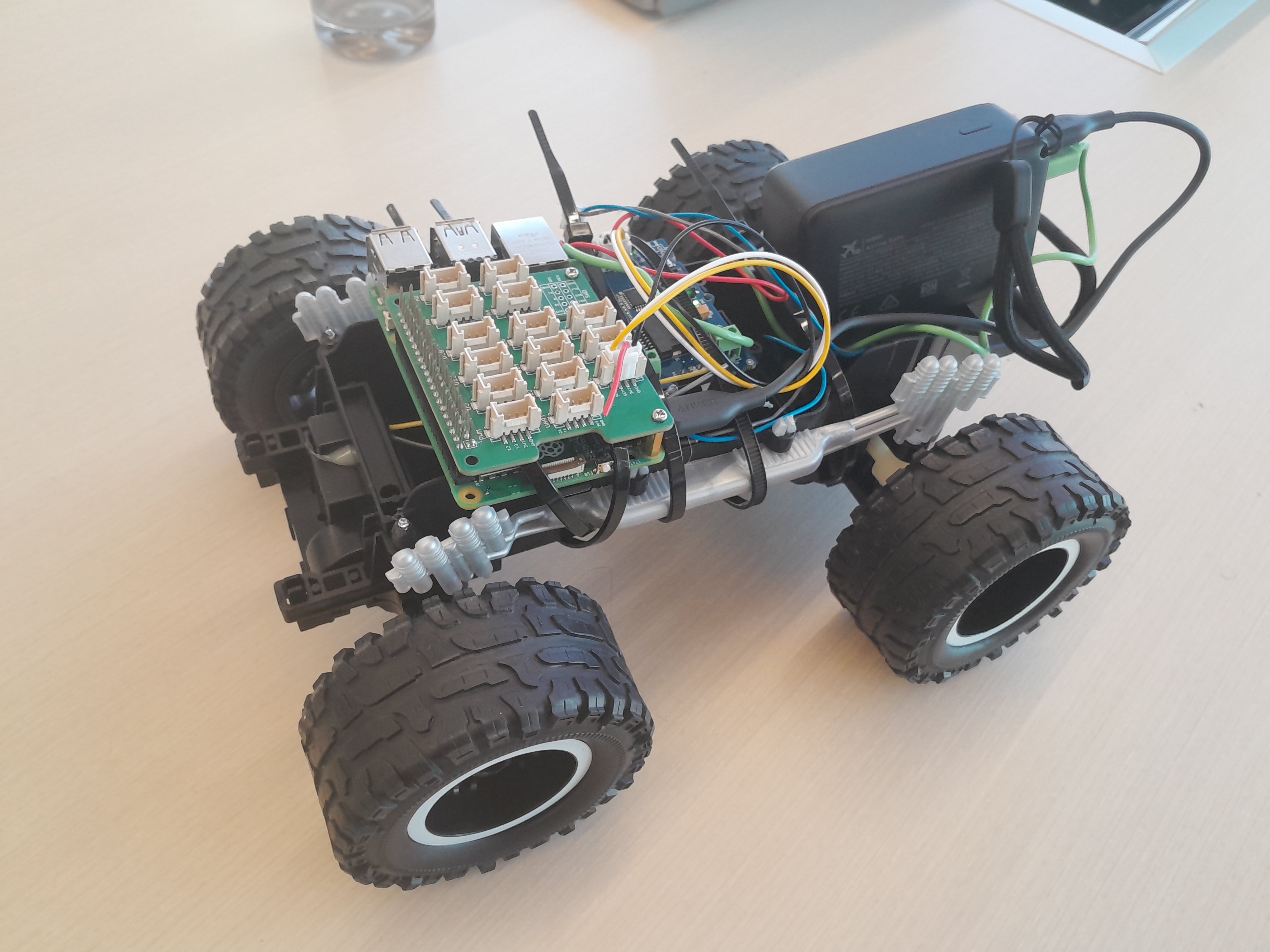
Built around a Raspberry Pi-powered robotic car, DC motors, a motor controller, and an iPhone 17 Pro camera, Premiere combines physical exploration with digital environmental reconstruction.
The platform focuses on five major capabilities:
1. Robotic property exploration
Our robotic car is designed to navigate abandoned buildings and surrounding properties, allowing inspections to be conducted remotely rather than requiring people to enter potentially dangerous environments. The Raspberry Pi serves as the robot's computing platform, interfacing with the motor controller and DC motors.
2. LiDAR-powered 3D reconstruction
Using the iPhone's LiDAR sensor, RGB camera, and Apple's ARKit framework, Premiere captures depth measurements, camera positions, and images of its surroundings.
The captured data is processed into 3D point clouds and can be used to train Gaussian splats, creating detailed visual reconstructions of indoor and outdoor environments.
3. Structural observation and inspection
Through our interactive Three.js interface, users can examine reconstructed environments and place observation markers directly onto scanned surfaces.
Each observation can include a description, supporting camera imagery, and a review status. This makes it possible to document visible cracks, damaged surfaces, and other potential structural concerns for further professional evaluation.
4. Environmental and soil-quality assessment
Premiere is also designed to support environmental inspection, including future soil-quality monitoring around abandoned properties. Integrating soil sensors would allow the robot to collect environmental measurements alongside its spatial mapping data, helping inform redevelopment decisions.
5. Interactive neighbourhood modelling and redevelopment visualization
Beyond inspecting existing properties, Premiere helps users imagine what those spaces could become.
Our Three.js application allows users to:
- Explore reconstructed 3D environments through point clouds and Gaussian splats.
- Generate customizable house models with adjustable dimensions, floors, roof height, and appearance.
- Position, rotate, and scale proposed houses within captured environments.
- Compare existing conditions with proposed redevelopment models.
- Visually hide selected portions of an existing scan to simulate replacing structures.
Together, these capabilities transform Premiere from a robotic inspection concept into an interactive platform for understanding and reimagining urban spaces.
How we built it
Premiere combines hardware, mobile development, backend data processing, and browser-based 3D visualization.
Hardware and robotics
We designed the robotic platform around a Raspberry Pi, DC motors, and a motor controller, using a mobile robotic chassis to carry our scanning equipment.
An iPhone 17 Pro serves as the primary imaging device, providing RGB imagery, LiDAR depth measurements, and motion tracking through ARKit.
The Raspberry Pi and motor controller form the foundation for robotic movement, with autonomous navigation and obstacle avoidance planned as further integrations.
iOS scanning application — SwiftUI and ARKit
We developed a native iPhone application using SwiftUI and ARKit to capture environmental data.
For each recorded frame, the application collects:
- RGB camera imagery.
- LiDAR depth and confidence measurements.
- Camera calibration information.
- ARKit camera poses and spatial transformations.
Captures are saved locally before being uploaded to our backend for processing.
Backend and reconstruction pipeline — Python and FastAPI
We built a FastAPI backend to manage capture sessions, file uploads, and reconstruction jobs.
Our Python processing pipeline transforms raw LiDAR depth measurements into world-space 3D point clouds, filters unreliable measurements using confidence data, and converts ARKit camera poses into COLMAP-compatible formats.
We also integrated Brush, a Gaussian-splat training tool, to support photorealistic 3D scene reconstruction from captured imagery and geometry.
Interactive 3D visualization — Three.js and SparkJS
We built a browser-based visualization interface using Three.js and SparkJS.
Users can load captured point clouds, inspect Gaussian splats, orbit around reconstructed environments, and interact with 3D observation markers.
We also implemented a procedural house-generation system using Three.js geometry, allowing users to customize building dimensions and interactively place proposed structures into scanned environments.
Our comparison interface supports existing, proposed, and overlay views, along with configurable 3D regions for visually removing portions of a capture.
Technologies used
Raspberry Pi, DC Motors, Motor Controller, iPhone LiDAR, Swift, SwiftUI, ARKit, Python, FastAPI, Three.js, JavaScript, SparkJS, Brush, Gaussian Splatting, COLMAP, HTML/CSS, and Vite.
Challenges we ran into
1. Integrating robotics hardware with our software
One of our biggest challenges was bringing together multiple hardware components: the Raspberry Pi, DC motors, motor controller, and iPhone scanning system.
We had to consider motor power requirements, controller compatibility, physical mounting, and how the robot's movement would coordinate with environmental scanning.
Unlike a purely software-based project, robotics requires every physical and digital component to work together reliably.
2. Converting LiDAR data into accurate 3D geometry
Raw LiDAR data cannot simply be displayed as a finished 3D model.
We had to handle depth confidence, camera calibration, coordinate transformations, and alignment between captured images and spatial measurements.
Even small mistakes in coordinate systems could produce distorted or incorrectly positioned geometry.
3. Managing camera tracking and reconstruction quality
ARKit tracking is sensitive to environmental conditions. Poor lighting, rapid movement, reflective surfaces, and insufficient image overlap can affect reconstruction quality.
This was particularly important for our use case because abandoned buildings may contain dark rooms, narrow passages, and irregular surfaces.
4. Connecting physical environments with interactive 3D models
Building an interactive 3D viewer required more than simply rendering a point cloud.
We needed to implement surface selection, persistent inspection markers, camera controls, procedural house generation, and transformations that allowed proposed buildings to be positioned relative to captured geometry.
We also had to ensure that observation markers remained associated with their original scan coordinates while users manipulated redevelopment models.
5. Balancing ambition with hackathon constraints
Our long-term vision includes autonomous exploration, structural analysis, environmental sensing, and neighbourhood-scale mapping.
Implementing every component within a hackathon timeframe required us to prioritize a working reconstruction and visualization pipeline while developing the robotic platform toward full autonomy.
Accomplishments that we're proud of
Our biggest accomplishment was building the foundation of a system that connects real-world environmental capture with interactive 3D redevelopment visualization.
We're particularly proud of:
- Building a complete LiDAR processing pipeline: From an iPhone capture application to a Python backend that prepares real 3D point-cloud geometry.
- Integrating Gaussian-splat reconstruction: Supporting a workflow that transforms captured spatial data into detailed visual representations using Brush and SparkJS.
- Creating an interactive inspection interface: Allowing users to attach observations, descriptions, evidence photos, and review statuses to locations in a reconstructed environment.
- Developing procedural 3D house modelling: Giving users control over building dimensions, floors, roofs, placement, rotation, and scale.
- Implementing redevelopment comparison tools: Supporting visual overlays and selective hiding of existing geometry to help illustrate potential property transformations.
- Building and validating our software foundation: Passing backend pipeline and observation tests, producing a successful frontend build, and testing the 3D viewer with synthetic geometry.
- Combining multiple engineering disciplines: Bringing together robotics, mobile development, computer vision, backend engineering, and 3D graphics around one practical problem.
Most importantly, we developed a platform with applications beyond a single hackathon: safer property documentation, architectural visualization, and data-informed urban redevelopment.
What we learned
Building Premiere pushed us to explore technologies and engineering concepts outside our usual comfort zones.
Robotics and hardware integration: We gained a deeper understanding of how Raspberry Pi systems, motor controllers, DC motors, and physical power constraints affect the design of mobile robots.
Computer vision and spatial computing: We learned how ARKit combines camera tracking, depth sensing, and calibration to represent physical environments digitally.
3D reconstruction: We explored point clouds, COLMAP camera formats, Gaussian splatting, and the importance of accurate coordinate transformations.
Full-stack systems engineering: We learned how to connect a native iOS application, a Python processing backend, and a JavaScript visualization frontend into a coordinated workflow.
Interactive 3D graphics: Working with Three.js taught us about scene graphs, transformations, raycasting, camera controls, procedural geometry, and spatial user interfaces.
Engineering tradeoffs: We learned that an impressive visual reconstruction is not automatically an accurate engineering measurement. Reliable structural inspection and autonomous navigation require additional validation, sensing, and safety systems.
Above all, we learned how challenging and rewarding it is to build a project that bridges the physical and digital worlds.
What's next for Premiere
We see Premiere as the beginning of a larger platform for autonomous property inspection and urban redevelopment.
Our next steps include:
1. Full autonomous navigation
Integrate robotic motor control, obstacle avoidance, wheel odometry, and SLAM-based mapping so Premiere can navigate properties with minimal human intervention.
2. AI-powered structural damage detection
Train or integrate computer vision models capable of identifying visible cracks, surface deterioration, moisture damage, and other potential warning signs from captured imagery.
These detections would be flagged for professional review rather than treated as certified structural assessments.
3. Soil and environmental sensing
Add soil moisture, pH, and other environmental sensors to collect ground-condition data around properties, supporting more comprehensive site assessments.
4. Neighbourhood-scale digital twins
Expand beyond individual building scans to connect multiple properties into a navigable 3D neighbourhood map, allowing users to understand surrounding infrastructure and redevelopment opportunities.
5. AI-assisted redevelopment planning
Introduce intelligent recommendations for possible property layouts, building configurations, and redevelopment scenarios based on captured geometry and user-defined constraints.
6. Real-time reconstruction
Move from our current capture-upload-process workflow toward continuous streaming and live 3D mapping as the robot explores its surroundings.
Our ultimate goal is to make Premiere a system that can explore a property, document its condition, reconstruct its environment, and help visualize its future — making urban inspection and redevelopment safer, smarter, and more accessible.


Log in or sign up for Devpost to join the conversation.