-
-

Our models
-
DL Final Poster
-
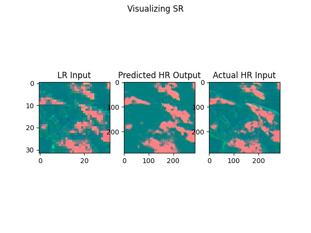
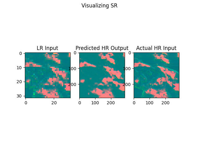
Model outputs
-

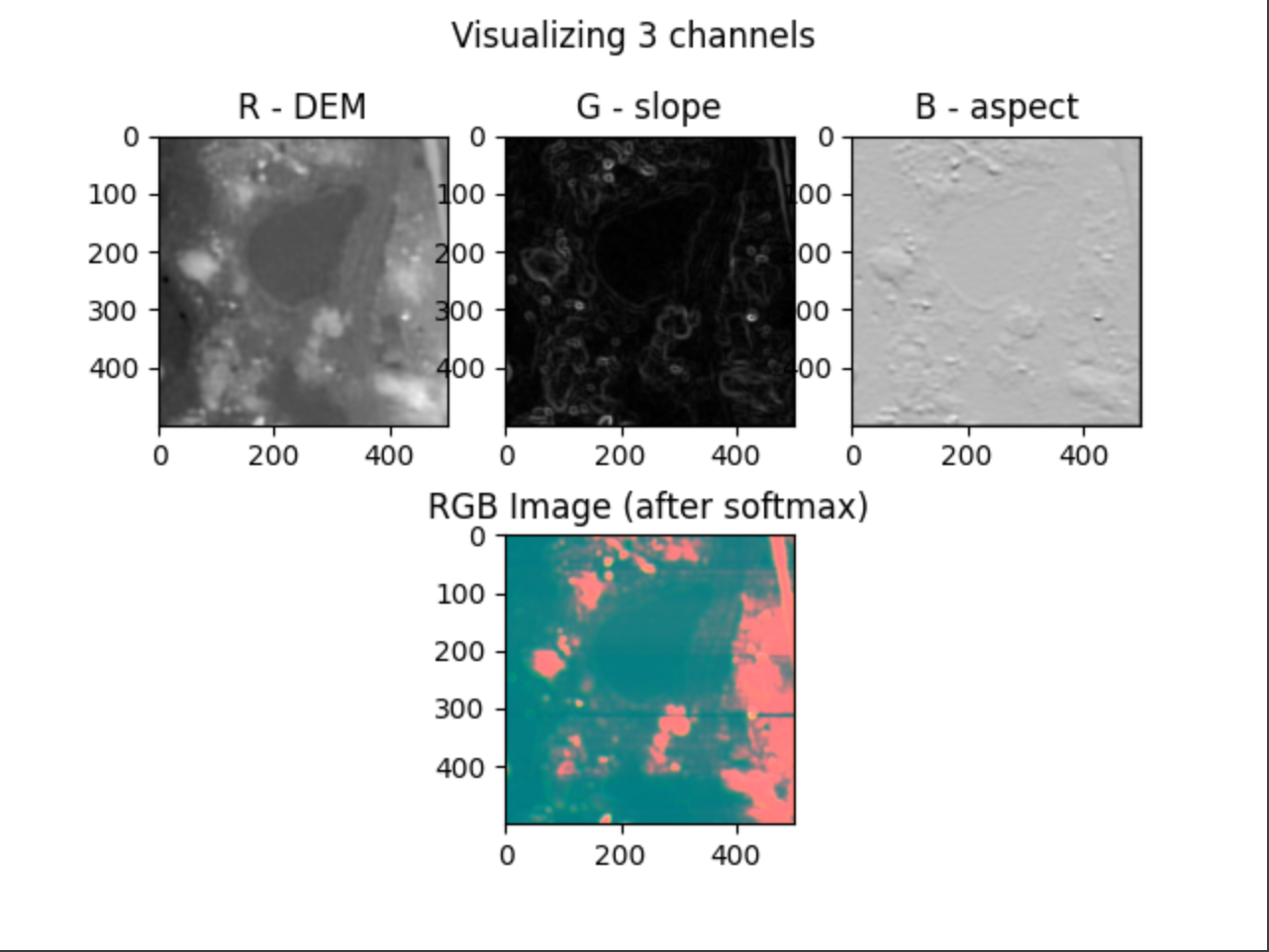
Visualizing 3 channels
-

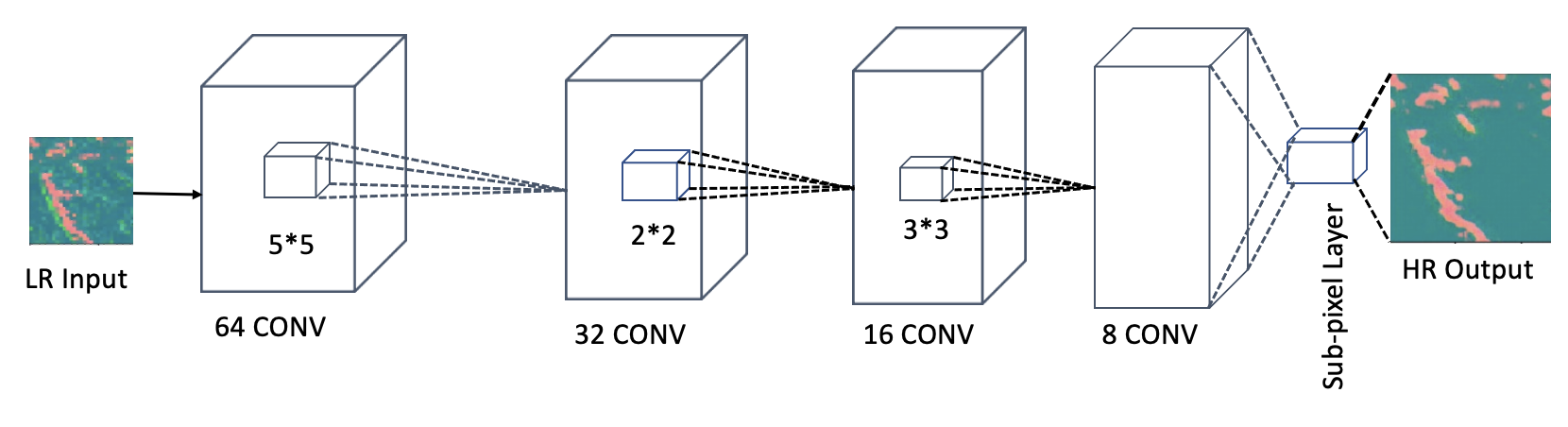
Vanilla CNN
-
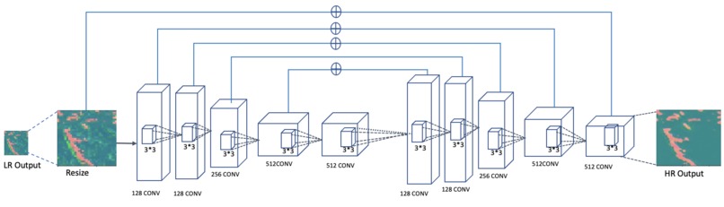
PreUpsampling CNN
-

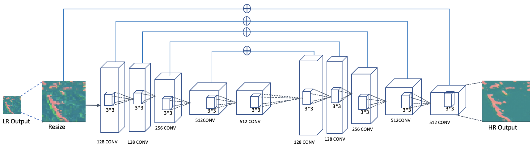
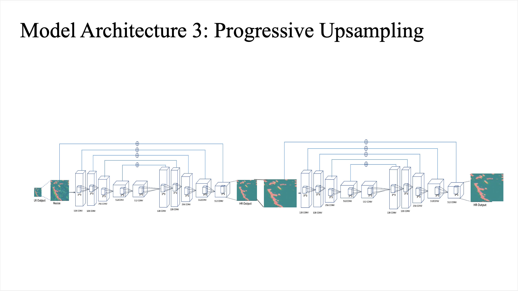
Progressive Upsampling CNN

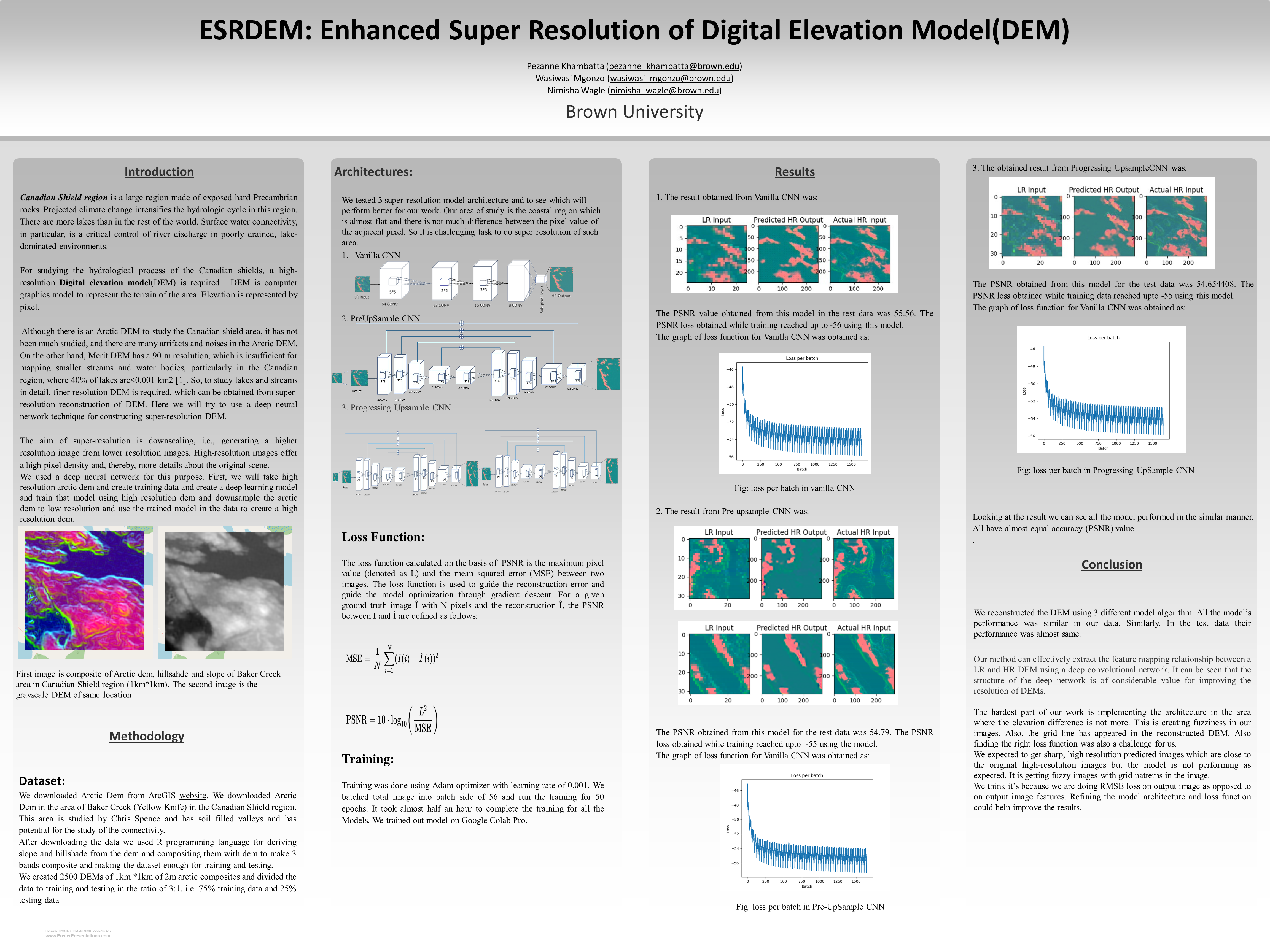
ESRDEM: Enhanced Super-resolution of DEM using CNN
Project Members
pezanne_khambatta@brown.edu, nimisha_wagle@brown.edu, wmgonzo@brown.edu
Presentation Video, 12/9: https://drive.google.com/file/d/1rjmKflJyG74PgVgvVprXrO-qTzv_WFhR/view?usp=sharing
Folder containing presentation slides and write up - https://drive.google.com/drive/u/1/folders/1rk8Tr2ZvDDLb3izE1kdhzk0Dipcyy-XA
Reflection, 11/30: https://docs.google.com/document/d/1NC-G6q-lpnObftvCgtqviVJ52Yx_ge6y2dVWlobeu1w/edit?usp=sharing
Introduction:
What problem are you trying to solve and why? If you are implementing an existing paper, describe the paper’s objectives and why you chose this paper. If you are doing something new, detail how you arrived at this topic and what motivated you.
Nimisha was doing her research on surface water connectivity mapping. She needed to map surface water in the Canadian shield and see the things that cause switch on and switch off in the movement of water. The Canadian shield contains very narrow rivers and lakes with <10m resolution.
DEM is of great importance to geographers in performing hydrological modelling and simulation. They currently have access to arctic DEM - a dataset with a high resolution of 2m. However, due to large gaps and jumps in the arctic DEM data, they choose not to use it for research and analysis. Instead, they rely on Merit DEM, which has a low resolution of 90m, which is not sufficient to map the area. Our team’s focus is to increase the resolution of and thereby resolve “choke points” in the lower resolution Merit DEM. Choke points are the points which cause switching off of the water when there is low flow and switching on the water when there is high flow. They are an essential component in understanding the hydrological process.
If our project is successful and produces great results, it would have a great impact in the field of hydrology.
What kind of problem is this? Classification? Regression? Structured prediction? Reinforcement Learning? Unsupervised Learning?
Semi-supervised Learning (CNN).
Related Work: Are you aware of any, or is there any prior work that you drew on to do your project? Please read and briefly summarize (no more than one paragraph) at least one paper/article/blog relevant to your topic beyond the paper you are re-implementing/novel idea you are researching.
In this paper, authors tested whether super-resolution (SR), the resampling of coarse imagery to a finer-than-native resolution, can detect dynamical changes in the coastline of the Canadian Shield. They degraded high-resolution Planet CubeSat images of the Shield, then resample the coarsened imagery back to its native resolution using both traditional cubic resampling and a generative adversarial network, a type of neural network often used for SR. To test classification accuracy from the generated SR imagery, they applied the same water classification to both resampling methods and found similar performance based on confusion matrices with the control case of high-resolution imagery. Next, They compared fine-scale shoreline mapping in SR imagery, cubic resampling, and in-situ field surveys. SR shorelines outperform those from cubic resampling, with an increase in the modified kappa coefficient from −0.070 to 0.073. Potential applications include improved mapping of Shield lakes and retroactive application of SR to coarser-resolution satellite datasets to infer historical changes in fine-scale surface water dynamics.
Super-resolution reconstruction of a digital elevation model based on a deep residual network
This paper designs a neutral network model with 30 convolutional layers to learn the feature mapping relationship between a low and high-resolution DEM. To avoid the problem of network degradation caused by increasing the number of convolutional layers, residual learning is introduced to accelerate the convergence speed of the model, thereby preferably realizing the DEM super-resolution process. The results show that DEM super-resolution based on a deep residual network is better than that obtained using a neural network with fewer convolutional layers, and the reconstructed result of the DEM based on a deep residual network is remarkably improved in terms of the peak signal to noise ratio and visual effect.
The model in this paper has room for improvement when trying SR flat areas with water bodies, as opposed to mountainous areas.
In this section, also include URLs to any public implementations you find of the paper you’re trying to implement. Please keep this as a “living list”--if you stumble across a new implementation later down the line, add it to this list. Living List of Links
Data Resources Arctic DEM Dataset https://www.arcgis.com/apps/webappviewer/index.html?id=aff5fa8f5d5548c6bff44cc8be385f61
Merit DEM http://hydro.iis.u-tokyo.ac.jp/~yamadai/MERIT_DEM/
Model Architecture Resources
Deep Learning for Image Super-Resolution https://www.analyticsvidhya.com/blog/2021/05/deep-learning-for-image-super-resolution/
Deep learning based super resolution, without using a GAN https://towardsdatascience.com/deep-learning-based-super-resolution-without-using-a-gan-11c9bb5b6cd5
D-SRGAN: DEM Super-Resolution with Generative Adversarial Networks https://link.springer.com/article/10.1007/s42979-020-00442-2
Super-resolution reconstruction of a digital elevation model based on a deep residual network https://www.degruyter.com/document/doi/10.1515/geo-2020-0207/html
Deep gradient prior network for DEM super-resolution: Transfer learning from image to DEM https://www.sciencedirect.com/science/article/abs/pii/S0924271619300413
Convolutional Neural Network Based Dem Super Resolution https://noa.gwlb.de/servlets/MCRFileNodeServlet/cop_derivate_00012657/isprs-archives-XLI-B3-247-2016.pdf
Fusion of multi-scale DEMs using a regularized super-resolution method https://www.tandfonline.com/doi/abs/10.1080/13658816.2015.1063639?casa_token=l9JaTFaeS80AAAAA%3AwWfAQxsnHKXwPI44hXyZHw5lxXKqdMpKHwG3yWEVAo8roawh7mtV5TG8zSjYsITFwUVHIsfezAQj&journalCode=tgis20
Related Information
Digital Elevation Model https://en.m.wikipedia.org/wiki/Digital_elevation_model
Downscaled High Resolution Datasets for Climate Change Projections https://www.enviro.wiki/index.php?title=Downscaled_High_Resolution_Datasets_for_Climate_Change_Projections
High-resolution gridded climate data for Europe based on bias-corrected EURO-CORDEX: the ECLIPS-2.0 dataset https://zenodo.org/record/3952159#.YY7uMy1h2E0
Data: What data are you using (if any)? If you’re using a standard dataset (e.g. MNIST), you can just mention that briefly. Otherwise, say something more about where your data come from (especially if anything is interesting about how you will gather it).
We are using ArcticDEM and MeritDEM. We will select the area we want the DEM data for and download just that data. http://hydro.iis.u-tokyo.ac.jp/~yamadai/MERIT_DEM/
How big is it? Will you need to do significant preprocessing? Roughly 2.3GB. We might be downgrading the resolution.
Methodology: What is the architecture of your model? **How are you training the model?
If you are implementing an existing paper, detail what you think will be the hardest part about implementing the model here.**
For CNN - Convolve over training images (DEMs), etc.
For RNN - Pass training data into LSTM or GRU, etc.
More research is required on combining CNN and RNN for images / DEMs.
If you are doing something new, justify your design. Also note some backup ideas you may have to experiment with if you run into issues. This paper says that a combination of CNN (ResNet) and RNN would be helpful to effectively resolve coastal places with abundant rivers and lakes.
Metrics: What constitutes “success?” What experiments do you plan to run?
We will generate Super resolution DEMs of Merit DEM and calculate its RMSE or MSE against the corresponding DEM of Arctic DEM. For most of our assignments, we have looked at the accuracy of the model. Does the notion of “accuracy” apply for your project, or is some other metric more appropriate? “Accuracy” does not apply to our project. We are evaluating it based on RMSE and MAE. RMSE is Root Mean Square Error which will be calculated by taking the difference between the elevation in original high resolution DEM and Generated High resolution DEM. MAE is mean absolute error and it is calculated by taking the mean of the absolute values of the individual prediction errors on over all instances in the test set.
If you are implementing an existing project, detail what the authors of that paper were hoping to find and how they quantified the results of their model. NA
If you are doing something new, explain how you will assess your model’s performance. What are your base, target, and stretch goals? Having low RMSE or MAE constitutes success.
Ethics: Choose 2 of the following bullet points to discuss; not all questions will be relevant to all projects so try to pick questions where there’s interesting engagement with your project. (Remember that there’s not necessarily an ethical/unethical binary; rather, we want to encourage you to think critically about your problem setup.)
What broader societal issues are relevant to your chosen problem space? Why is Deep Learning a good approach to this problem?
Size of the dataset, improved results from similar approaches, combination of different methodologies would yield better results.
How are you planning to quantify or measure error or success? What implications does your quantification have?
Quantification: Discussed above (RMSE or MAE). Implication: Low RMSE/MAE over test data implies the model is successful.
Division of labor: Briefly outline who will be responsible for which part(s) of the project.
All people will work together.
Built With
- keras
- python
- tensorflow


Log in or sign up for Devpost to join the conversation.