EcoSense is an AI-powered pollution dashboard for Jaipur. It uses satellite data & predictive AI to simulate policy impacts and verify hotspots , enabling proactive city governance.
Inspiration = Our journey began with a simple, unsettling realization: City-wide averages lie.While checking Jaipur’s AQI, we noticed that while the "City Average" often read a moderate 150, specific industrial pockets like Sitapura were choking at 400+.Current pollution control is Reactive—authorities wait for the smog to settle before acting, often implementing blanket bans (like "Odd-Even") without knowing if they will work. We wanted to build a tool that shifts governance from Reactive to Proactive. We asked: "What if an officer could simulate a policy virtually before enforcing it on the ground?" Thus, EcoSense was born.
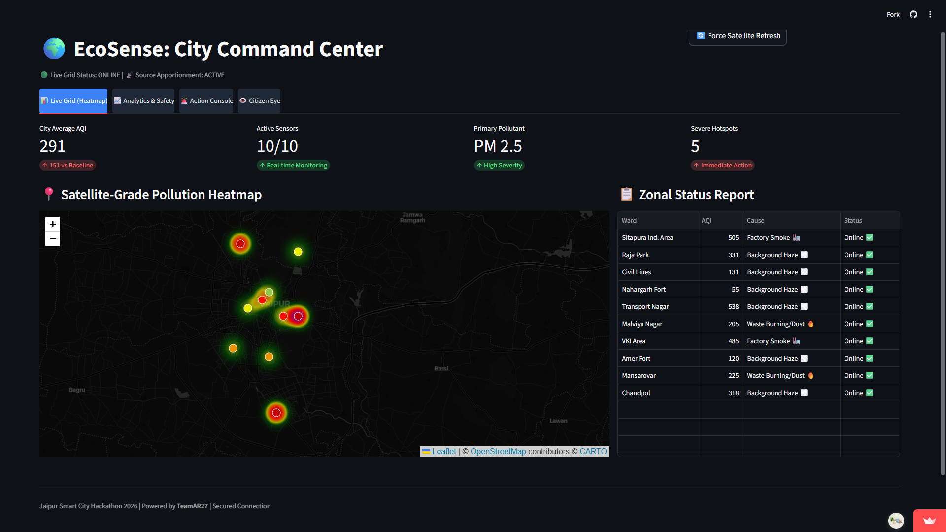
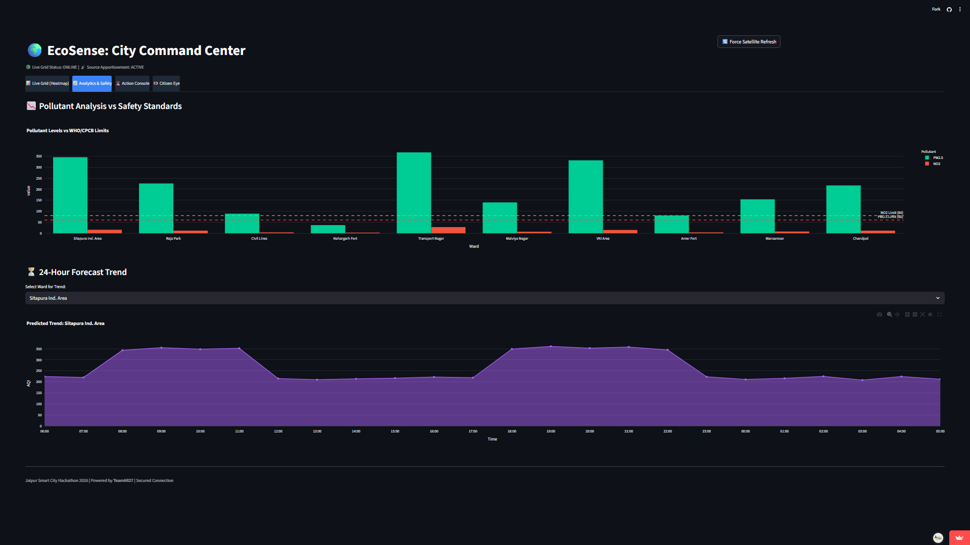
What it does = EcoSense is a "Governance Cockpit" creating a Digital Twin of Jaipur's environmental health. It empowers authorities to:Monitor Hyper-Locally: View a satellite-grade heatmap of specific wards, identifying micro-hotspots invisible in city-wide reports.Simulate Strategies: Use our Predictive Math Engine to test policies (e.g., Factory Shutdowns, Traffic Diversions) and see their projected impact on AQI before implementation.Verify Ground Truth: Use Computer Vision (Gemini 1.5 Flash) to analyze citizen/officer photos, distinguishing between mere fog and illegal biomass burning.Act Instantly: Auto-dispatch alerts to specific Ward Officers and draft legal notices (Section 144) in Hindi & English in seconds.
How we built it = We architected EcoSense as a modular, scalable platform:The Brain (AI): We leveraged Google Gemini Pro for reasoning (policy drafting) and Gemini 1.5 Flash for high-speed Computer Vision analysis.The Math (Simulation): We built a stochastic simulation engine in Python (NumPy/Pandas) that calculates Delta AQI based on weighted reduction factors ($\alpha$) specific to ward topology (Industrial vs. Residential).The Map (Geospatial): We used Folium and Leaflet.js to render real-time pollution heatmaps overlaying OpenWeatherMap satellite feeds.The Interface: We wrapped it all in Streamlit with custom CSS to create an enterprise-grade "Dark Mode" command center experience
Challenges we ran into = The "Black Box" of Simulation: Creating a mathematical model that felt realistic was difficult. We had to research and fine-tune the "Reduction Factors" so that an Odd-Even Rule didn't artificially drop pollution to zero, but showed a realistic 15-20% variance.Multimodal Latency: Processing high-res images for Computer Vision while fetching live API data caused lag. We solved this by implementing asynchronous calls and using the faster Gemini Flash model over Pro.Language Localization: Generating legal Hindi text that was grammatically correct and legally sound required extensive prompt engineering to handle Devanagari script rendering correctly.
Accomplishments that we're proud of = The "What-If" Engine: Successfully building a module where a user can toggle a checkbox and see a mathematical projection of the future—something usually found only in expensive enterprise software.Citizen Sentinel Integration: Seamlessly bridging the gap between a raw camera input and a complex pollutant analysis report in under 3 seconds.Field-Ready Realism: The system doesn't just show data; it "knows" which officer is on duty in Chandpol vs. Mansarovar, making it feel like a deployed government tool.
What we learned = Data needs Context: A sensor reading of "300 AQI" is useless without knowing why. Adding the "Cause Analysis" logic (Traffic vs. Industry) completely changed the utility of the app.Human-in-the-Loop is Key: AI shouldn't replace the officer; it should empower them. Our decision to have AI draft notices rather than send them was a crucial insight for government adoption.Speed is a Feature: In emergency response, a dashboard that loads in 2 seconds is infinitely better than a complex one that loads in 20.
What's next for Ecosense: city command centre = IoT Mesh Network: Moving beyond satellite data to integrate low-cost ESP32 ground sensors for street-level accuracy.Drone Integration: Deploying autonomous drones to "Green Zones" to capture aerial evidence for the Vision engine.Public API: Releasing a read-only version of the "Citizen Eye" score so real-estate apps can show "Health Ratings" for neighborhoods

Log in or sign up for Devpost to join the conversation.