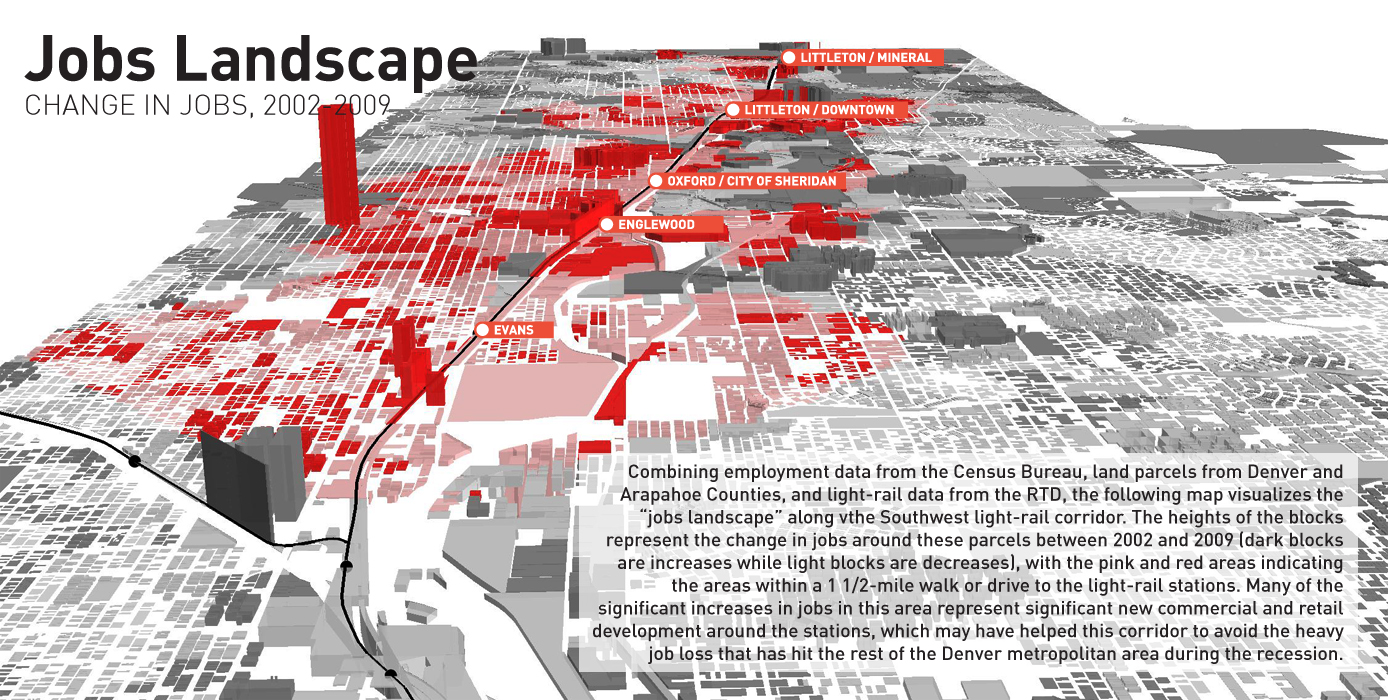
With limited public sector resources, assuring effective return ontaxpayer investment is an important factor in making decisions onwhich projects to fund. The graphics that follow visualize information representing economicdevelopment that can result from investment in transportationimprovements. While there is no single measure of economicdevelopment, data on changes in employment, wage levels, population,and housing between 2000 and 2010 paint a picture of the economicchanges that occurred in the years following a major transportationinvestment. This work uses a major light-rail extension in Denver as a case studyto visualize economic development data, but the techniques used herecould be applied to any type of transportation project to evaluate itseconomic impact. The underlying data, compiled from a variety ofpublicly available sources, presents a synthesis of spatial andstatistical information. In July 2000, the Denver metropolitan area's Regional Transportation District(RTD) completed the 8.7-mile Southwest extension of its light railsystem. The new route served Denver and Arapahoe Counties with fivenew train stations at a cost of $176.32 million, of which the federalgovernment chipped in $120 million through the New Starts grantprogram. The line attracts thousands of daily riders but it has also beencredited as an important element of the Denver region's efforts toexpand mobility and decrease pollution, as is recommended in the NewStarts evaluation process. About ten years later, the project serves as a useful case study fortransit projects across the United States, demonstrating how publiclyavailable information can be readily used to evaluate the economicimpact of a major transportation project. In the series ofvisualizations that follow, we hope to show how Census and GIS dataserve to highlight changes in job, population, and housing growthalong the light rail corridor. Similar techniques and tools could beutilized to evaluate economic performance of similar investmentsacross the country, helping to clarify the value of public investmentin infrastructure. This study evaluates the performance of station areas located within1.5 miles of the five new stations of the Southwest rail extension andcompares this to changes in the 2-county core area of Denver andArapahoe Counties, generally over the ten-year period between 2000 and2010.
Economic Development Through Infrastructure: A Visual Case Study of a Major Transportation Investment
Updates
Leave feedback in the comments!
Log in or sign up for Devpost to join the conversation.