Project Story
Inspiration
We built Earth OS because environmental information is already available in many forms—maps, datasets, reports, news, and different dashboards—but it is often spread across different tools. We wanted to explore a simpler idea: what if Earth itself could become the interface for understanding environmental information?
Instead of making users search through multiple platforms, we wanted to create one interactive environment where they could explore a location, ask questions, and understand the information through visual interaction.
The Problem
Environmental information can be difficult to understand when it is fragmented across different sources and interfaces. A user may have access to the data, but still need to switch between maps, dashboards, reports, and other tools to connect where something is happening, what is happening, and what the data means.
This creates a gap between having environmental data and actually understanding it.
The Existing Gap
Many existing tools are designed around individual datasets, maps, weather information, GIS analysis, or dashboards. These tools can be useful, but the experience is often focused on specific information rather than allowing users to interact naturally with Earth and connect different pieces of information.
Earth OS explores a different interface approach: Earth becomes the starting point of the interaction.
Our Solution
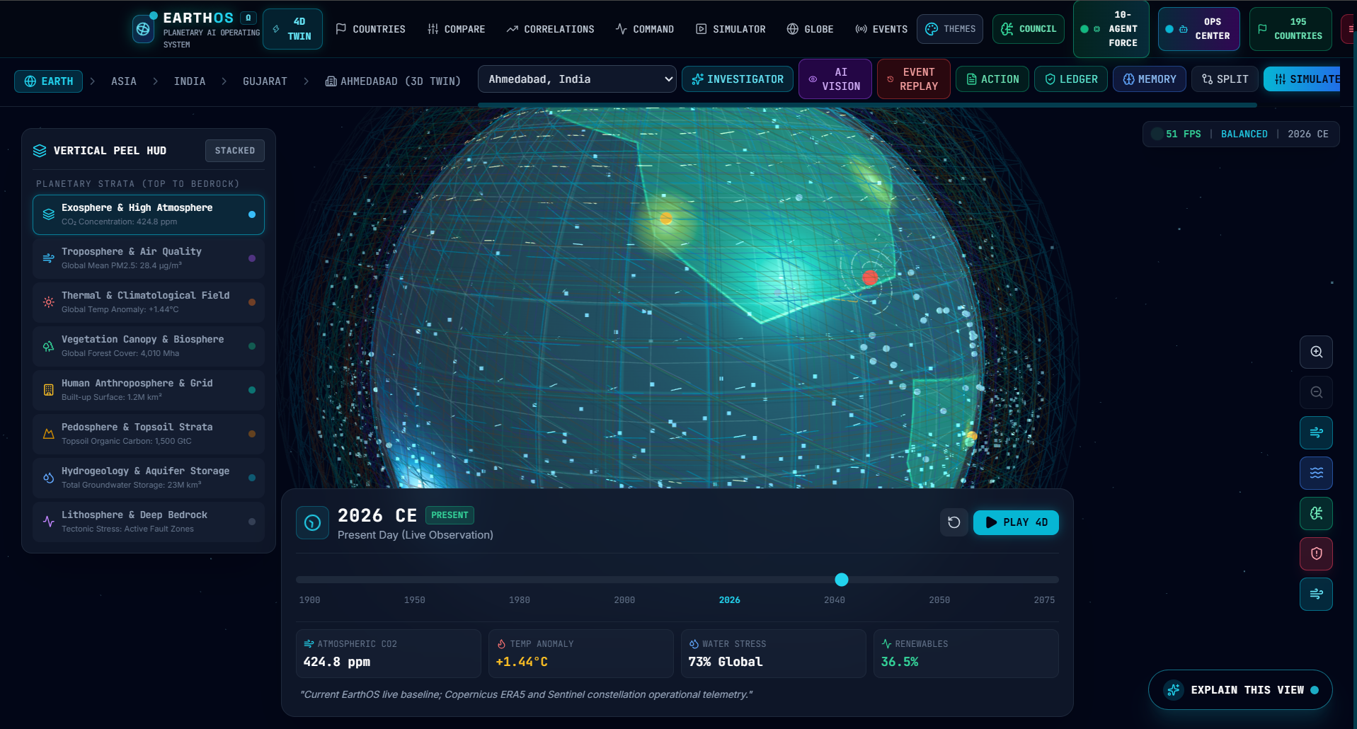
Earth OS is an AI-powered planetary intelligence platform designed to bring environmental and geographic information into an interactive Earth interface.
The core experience follows:
SEE → UNDERSTAND → ANALYZE → ACT
Users can explore Earth, interact with locations, access relevant information, and use AI-driven interaction to make complex information easier to understand.
The goal is not to replace existing environmental systems. Instead, Earth OS acts as an interface that can make available information easier to explore and interpret.
How It Works
The basic experience is designed around connecting the user's interaction with Earth to relevant information:
User Question / Interaction ↓ Location Understanding ↓ Relevant Environmental Information ↓ Visualization ↓ AI-Assisted Explanation ↓ User Insight
The exact capabilities depend on the implemented data sources and features of the current version.
What Makes It Different
The main idea behind Earth OS is not simply adding a chatbot to an environmental dashboard.
The project explores the concept of using Earth as the primary interface. Instead of starting with tables, menus, or separate dashboards, users can begin with a location and interact with environmental information around it.
Where supported by the implementation, AI can make this interaction more natural by allowing users to ask questions and receive understandable explanations instead of manually interpreting every piece of information.
Potential Impact
Earth OS could be useful for different types of users, including students, researchers, citizens, and planning or government teams.
For students, it can provide a more interactive way to explore environmental concepts. Researchers could potentially use such an interface to explore geographic and environmental information. Citizens could use it to understand information about places that matter to them.
More advanced applications for city planning, monitoring, reporting, and decision support are potential future directions rather than claims about the current implementation.
What We Learned
Building Earth OS required us to think beyond individual features and focus on how different parts of a technical system work together.
We learned about connecting an interactive interface with data, visualization, location-based interaction, and AI. We also learned an important lesson in building technology: a good idea is not enough unless the implementation can actually demonstrate it.
This influenced our approach to Earth OS—we focused on building a credible working experience rather than making unsupported claims about what the platform can do.
Challenges
One of the main challenges was bringing different types of information into a single user experience without making the interface complicated.
Another challenge was deciding where AI genuinely adds value. Instead of using AI simply because it is available, we focused on how natural-language interaction and explanation could make environmental information easier to understand.
Performance, data limitations, interface complexity, and maintaining a clear connection between user interaction and useful information are also important technical considerations.
Future Scope
Future versions of Earth OS could expand the number and variety of environmental data sources, improve historical and time-based analysis, add stronger monitoring capabilities, support richer environmental layers, and provide more advanced reporting and comparison tools.
The long-term vision is to build an intelligent interface layer over environmental information where users can explore Earth, ask questions, understand data, and discover insights through one connected experience.
Built With
- ai
- apis
- authentication
- css
- data
- database
- fiber
- generative
- geospatial
- gis
- javascript
- maps
- next.js
- react
- real-time
- rest
- tailwind
- three
- three.js
- typescript
- visualization
- webgl


Log in or sign up for Devpost to join the conversation.