-
-
-
TerraWatch

Inspiration
Deforestation has a profound impact on the planet. It displaces biodiversity, contributes to air pollution & climate change and disturbs ecosystems. It's paramount for all stakeholders to detect and take action to prevent further deforestation, but once detected, what action could you take to prevent it? TerraWatch identifies deforestation and provides you with insights, so that you can make informed decisions. With TerraWatch companies can verify they are sourcing responsibly, governments can prioritize interventions and NGO's are armed with the evidence they need.
What it does
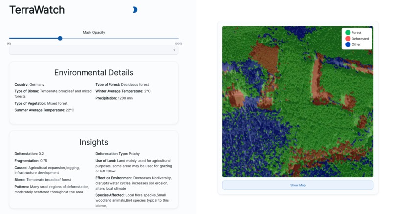
Using the embedded map (powered by Mapbox API) select an area of your interest and we provide you a colour coded mask on top of the satellite image as well as insights powered by LLM's. The semantic segmentation consists of three classes (Forest, deforestation and other) as opposed to just two classes, so that you can easily identify non-forest areas which are unlikely to be affected by deforestation.
How we built it
Frontend development with React
React Framework: By utilizing a modern JS framework from the start, the project is easily adapted to new use cases and production workloads. With the popularity of React the frontend stack is best suited for the future.
Material UI: With a styled component library (Material UI) the web app is designed to be user-friendly and modern. The components are lightweight and directly built using React. This ensures high performance and high reliability of the web app.
Mapbox: Integrating a satellite map directly into the web app ensures high user satisfaction and the ability to smoothly scan any area for deforestation effects. This ensures the web app is ready to tackle deforestation challenges across the globe.
LLM Integration: By adapting a multi-model solution the frontend is able to leverage the power of multiple models to not only segment images and display the deforested area to the user but also provide insights into the area. This includes environmental details and deforestation insights.
Backend powered by U-Net and LLM's
Our backend is powered by a U-Net CNN model. U-Net is a great fit for forest segmentation because it tackles key challenges:
Accuracy: U-Net excels at pinpointing forest borders in images, even intricate ones.
Data Efficiency: Training U-Net doesn't require massive datasets, ideal for potentially limited forestry imagery.
Context Matters: U-Net considers the bigger picture while focusing on details, crucial for separating forests from surroundings.
Easy to Use: U-Net's all-in-one design simplifies training compared to some other models.
We utilise two different LLM's for the insights. Co-ordinates of the selected area are provided to the fine tuned Llama3-70B model, from which we receive biodiversity insights.
We provide the multimodal GPT-4 Turbo LLM with the satellite image, color-coded mask output from U-Net, geolocation data and output from Llama3-70B in order to provide you with detailed insights into the potential causes of deforestation, affected species and effect on environment.
Challenges we ran into
Finding suitable datasets that have easy to use images and masks was a challenge. The dataset we used consists of 322 satellite images of Ukrainian forests taken from Google Earth Pro, each with semantic ground truth with 3 classes. The images are zoomed in a lot and the colour of the trees vary quite a bit, making it difficult for the model to generalize on different types of forest around the world.
Accomplishments that we're proud of
We successfully developed a prototype solution that can semantically segment a selected satellite image. Most importantly, we have developed a holistic solution, capable of providing you detailed insights into the area allowing the end-user to make informed decisions.
What we learned
- The most popular datasets consist of TIFF files that are not very easy to work with
What's next for Deforestation Detector
- Training the model on a more varied and larger dataset with semantic labels.
- Ability to select entire regions/countries after which TerraWatch searches the entire area for deforestation
- Choose between multiple models
Built With
- fastapi
- gpt4
- javascript
- llm
- love
- mapbox
- python
- react

Log in or sign up for Devpost to join the conversation.