-
-
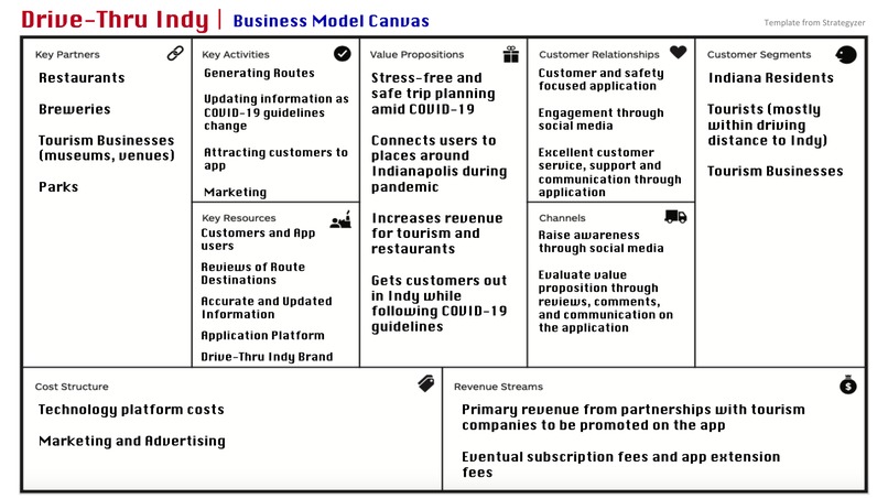
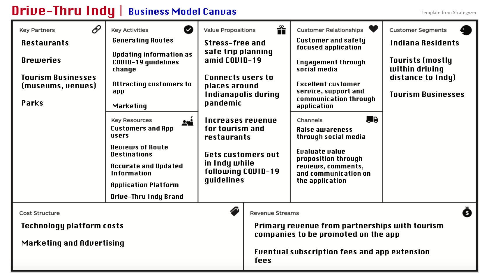
Business Model Canvas for Drive Thru Indy
-
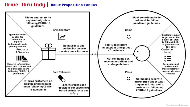
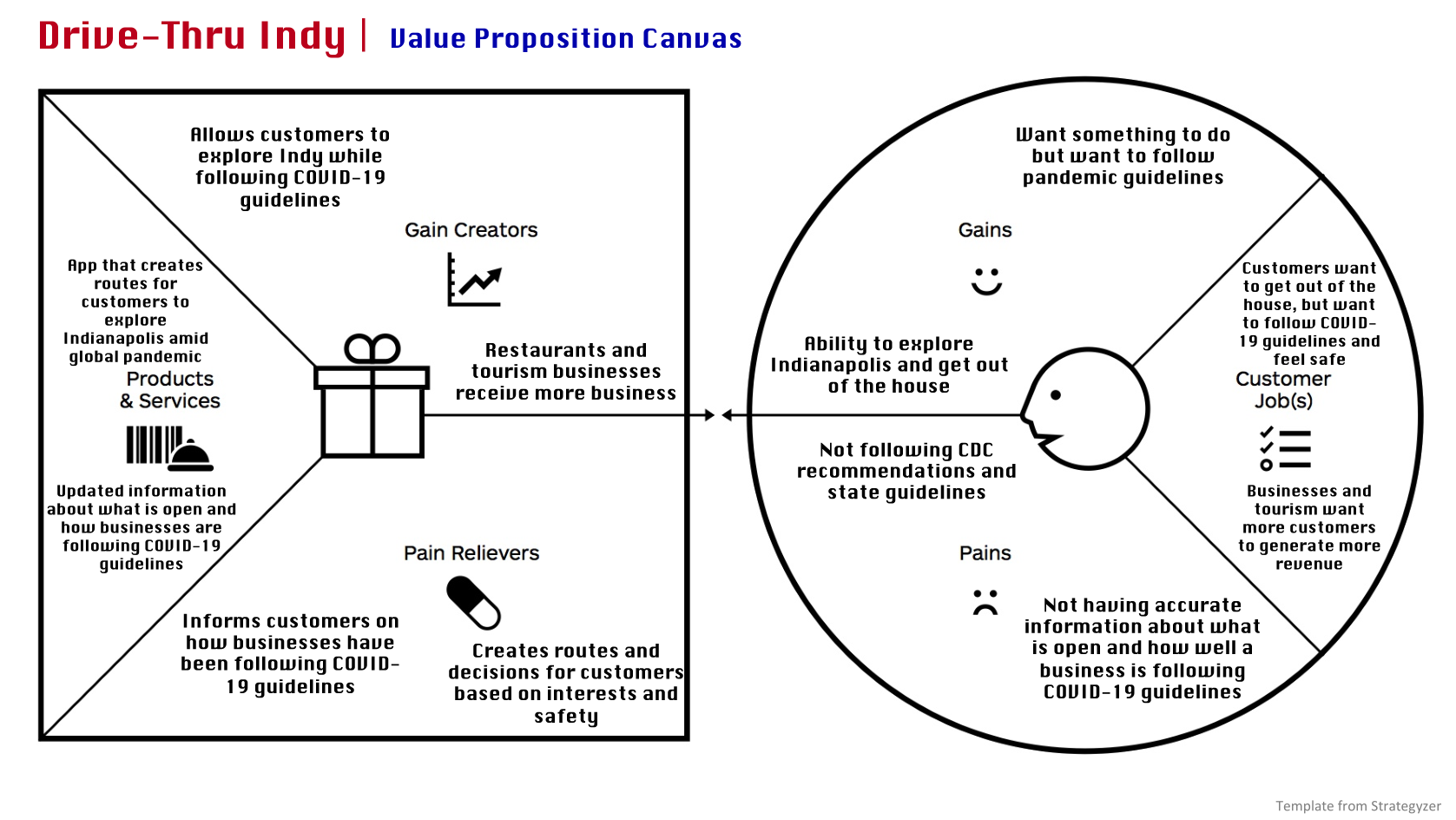
Value Proposition Canvas for Drive Thru Indy
-
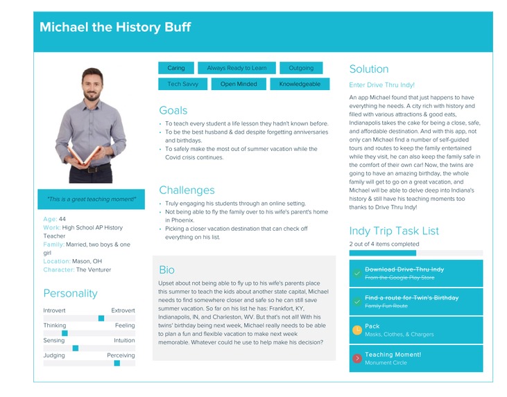
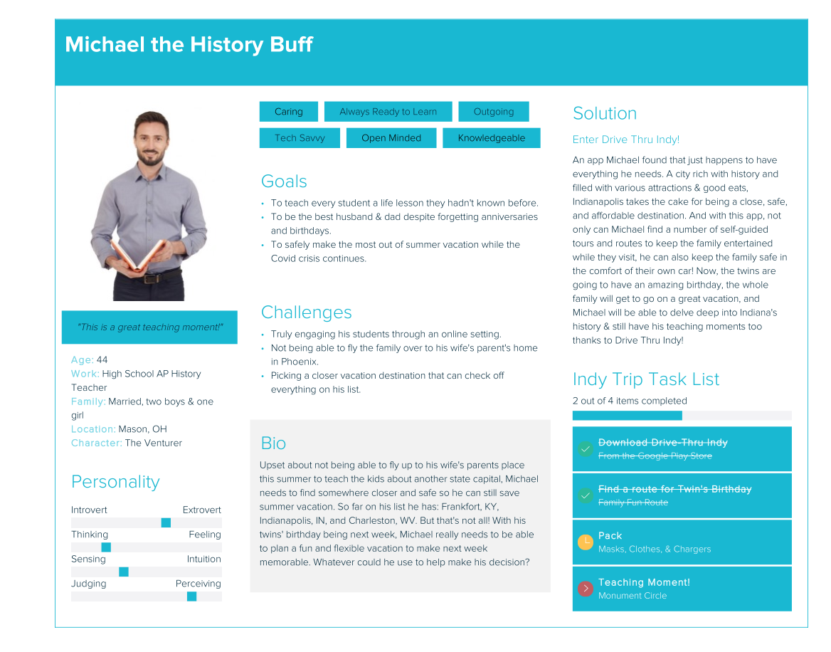
User Persona
Overview
Tourism (noun, /ˈto͝orˌizəm/): Travel for pleasure or business; also the theory and practice of touring, the business of attracting, accommodating, and entertaining tourists, and the business of operating tours.
Indianapolis (noun, /ˌɪn.di.əˈnæp.ə.lɪs/): A city rich with history that is home to countless events, filled with plenty of delectable eats, and holds many unique destinations within its reach. Indy definitely takes the cake for being a safe, affordable, and compelling center of activity.
Put those two nouns together and you have some of the best combinations to try and sights to see. Remove one from the other and all of a sudden, things get sticky. Indianapolis without Tourism is like a sunflower without the sun. What was once constantly growing and flourishing is now left to fend for itself as tourism in Indy has dwindled down due to Covid-19. And when there aren’t tourists here, businesses of all kinds start to suffer.
But no fear! Ctrl + S Indy has come up with a solution meant for all. Regardless of whether you’re a tourist or native to the city, an establishment that’s small or large, Drive-Thru Indy is an app that links the people to businesses they long to visit while keeping everyone up-to-date about their safety in the process. But what can you do with Drive-Thru Indy? Let us explain!
Drive-Thru Indy is a free app that enables you, Hoosiers, and tourists alike to find themed routes to truly explore the many gems of Indianapolis! Businesses that have a destination page on the app will automatically have Mask, Social Distancing, & Cleanliness star ratings. For added peace of mind, there are also Safety percentage ratings. Our goal is to make visiting your (new) favorite spots as effortless and safe as possible.
Team Members
Megan D'Silva (Project Manager, Informatics @ Ivy Tech) Megan was our team's UX Designer who jumped back and forth between helping the Pro and Go Squads. She took initiative when it came to Slack, Trello, and DevPost. Her main contributions were coming up with our final solution topic at a high-level, creating our Customer Persona with Xtensio, & contributing her voice and content to our presentation.
Augusta Irechukwu (Business Analyst, Senior Applied Computing Technology @ Colorado State University) Augusta was responsible for working with the Go Squad to complete the Environment Analysis and Business Model Canvas. She created the video depicting the issues we face when deciding where to go, when we go out, during the pandemic. In addition, she interviewed 4 people about our initial idea.
Kevin Daily (Software Engineer, Computer Science @ Purdue Fort Wayne) Kevin was our main application developer. He coded the frontend and backend of the survey portion of the application and implemented the geofencing aspect of the application. He also contributed by interviewing potential users about the idea, found a beta tester for the application, and created a video demonstrating the geofencing, notification, and survey portion of the application.
Shriyanshi Shikha (Computer Science and Mathematics @ Depauw University) Shriyanshi was our team's software developer who worked on the coding of the prediction model as well as collaborated with her Pro Squad members to help with the survey application features. She mainly worked in Android Studio and used Java for the coding of the survey application and Python for the prediction model.
Madison Webb (Marketing, Strategic Communications @ Butler University). Madison was a part of the Go Squad and helped to complete the Environmental Analysis, Value Proposition and Business Model Canvas. She assisted the team by developing the mock-up application in AdobeXD as well as editing the group’s final presentation video using iMovie.
How did you decide on this customer segment, problem, and solution?
Our team first began our research with hotels in mind, and the effects COVID-19 had on this industry. Through research we found more people, now than ever, are not engaging in leisure activities such as traveling. We then looked at the mechanism in which people would utilize to get to their desired travel location. Airplanes! Flying is the fastest way to get from one state to another. However, airlines are taking a huge hit due to the pandemic because we are advised against traveling to limit the spread of COVID-19. Due to this barrier, we focused on residents currently located in the state of Indiana and other states within driving distance.
Once we began to focus on residents, both local and near, we needed to better understand their concerns. Similar to residents in other states, it became apparent that people wanted a vacation away from home.
In the beginning, quarantining at home was the change many of us needed. But after weeks of being told to stay in doors and social distance, we all wanted a mini-vacation even if we couldn’t leave the state.
This is how Drive-Thru Indy came about. It is an app centered around getting Hoosiers out of their home for mini-vacation or a fun time and getting our surrounding state’s residents to come visit the heart of Indiana, all while keeping everyone safe.
How did your team build and iterate on the solution?
Our team’s iterations actually started with the ideas themselves. At first we were trying to come up with a solution we all agreed on that had to do with event spaces or hotels. But by the second Sprint Meeting, we figured out we could deviate a little bit from that and that’s what we did! Our solution encompasses tourism in Indy from a tourist’s standpoint. We created a solution that could be used by tourists and Indy natives alike.
Then when it came to the actual app design & development, our first mockup was simple and didn’t have as much substance or functionality as we had liked. Still, we did user testing on it anyways to get that important user feedback we needed. After that, we came up with a better design that had great functionality and a lot more features that would be vital to our app. And finally, we took some of those key features and made sure to implement them into our app for a well-rounded finish.
Key Metrics
16 interviews conducted
4 beta testers
Technical Architecture

The above diagram shows a basic architecture for our application. The user interacts with the frontend of the application, which is connected to the class files composing the backend of the app. The class files connect to a Receiver which monitors for events such as entering or exiting the geofence. The Google Maps API is used to generate static images of routes as well as provide navigation. The class files are connected to the database which stores the routes and locations, which can be fed to Google Maps for the navigation of the user chosen route. The answers given by users to the surveys for specific locations are used to make predictions about the safety of locations using machine learning. The predictions are then stored with the corresponding locations in the database and are displayed with the locations when users look at the specific routes and locations.
Our code can be found at our GitHub repo. Because of the short five week deadline, we decided to focus our efforts on the geofencing portion and machine learning portion of the application. The survey portion of the application was created and a single geofence was coded as a proof of concept. The machine learning was coded in Python and can also be found in the GitHub repo. In the final application, these two parts would be integrated into the larger application.
Our Mock-Up Design can be found here where you can click through the vision of our solution concept.
Key Tools, Libraries, and Frameworks
Tools/Libraries/Frameworks used for the Safety Prediction Model:
We used many python libraries for the prediction model but the most important library used in the final prediction was Surprise. Our goal was to make a recommendation system which is useful for recommending items to users based on their past preferences. Since we wanted to create a model that would be able to predict how safe a public place is based on the past experiences of users, the Sklean Surprise package became the most important tool. Other important libraries used were Pandas, Numpy and CSV. Pandas was used for the data analysis of the training and testing files as it is the most flexible and expressive data structure. Numpy and CSV were used to manipulate the arrays and read the files which is the most important task of data analysis.
Tools/Libraries/Frameworks used for the Survey Application:
We built our app using Android studio and chose Java as the main programming language since most of our pro team members were familiar with it. The Location Services API was used so that entering events could be received for the designated geofence. A Broadcast Receiver was used to monitor these enter events and send a notification to the user device when an event was received. In the final product, a dwelling event would be used to ensure the user is not just passing through a geofence, to reduce the possibility of notification spam, and to ensure the user is able to accurately answer the survey questions.
If you had another 5 weeks to work on this, what would you do next?
If we had another 5 weeks we would do the following:
- Collect the survey data of the most recent visits to the restaurants, bars, parks and other public places to be able to predict how safe it is to visit a particular place based on the current user ratings.
- Added more features to our app such as the ability to post the most recent pictures of the place by the user, finding nearby parking, and user-submitted routes which would only be published to the app by getting an affordable subscription to the application.
- Add a badge/sticker/trophy system attached to different actions by the user. If a user-submitted route is selected to be included in the app, a “Contributor” badge would be given to the user for display on their account. Badges could also be given for completing a certain number of routes in the same theme. This would give another reason for account creation, give a further sense of involvement with the app, and encourage the user to return to the app.
Work to extend the application to iOS so iPhone users can also use the app and to increase the number of users.
- In the longer run, we were also planning to collaborate with area restaurants and bars to have a QR code for the menu. This way, once the user enters the location they can scan the QR code and the app would automatically pull up the menu and payment information. This would help with the user check in as well as help maintain social distancing by reducing the interaction between the wait staff and the user.
Checklist of Completed Items
| Item | Confirmation of Submission | Explanation if not submitted |
|---|---|---|
| Environmental Analysis | ✓ | |
| Business Model Canvas | ✓ | |
| Value Proposition Canvas | ✓ | |
| Customer Persona(s) | ✓ |
Acknowledgments & Thank Yous
As a team we have a handful of important people we would like to thank who really motivated us to perform our best.
Firstly, our coaches from Edusource, Kendra and Jason Beutler. Kendra and Jason were there for us from helping narrow down our solution topic at the beginning all the way to giving us presentation feedback at the end. They sincerely made it a point to check up on us and give us strong advice & encouragement when we needed it the most. We really appreciate them making the time for us each week without fail regardless of how busy things got.
Next, we’d like to make sure to thank our families and friends who helped us with brainstorming, interviews, user testing, and overall feedback. We know that our solutions wouldn’t be as developed as it is without them. They were also very patient with our busy schedules and really helped us to devote the time needed to complete this challenge.
Lastly, we want to give a huge thanks to Techpoint and all their team members, guest coaches, and special guests for making this Challenge possible and helping us through every step of the way for it. We really enjoyed & discovered so much in all the sprint meetings, breakout rooms, and additional programming they hosted for us. Without the Techpoint team, this opportunity wouldn’t have been possible and we really value them for their time & effort in creating the S.O.S. Challenge for us.




Log in or sign up for Devpost to join the conversation.