-
-
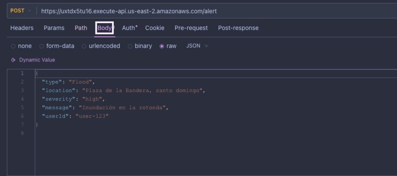
request sending alert using api gateway through lambda function

Inspiration
Currently Dominican Republic faces challenges with crisis reporting, including traffic accidents, fires, flooding and natural disasters. Despite widespread mobile usage, there’s a gap in how citizens can quickly alert authorities or others nearby. I was inspired by this gap, and I have the idea of system that would enable real-time emergency alerts, enhanced with geolocation, and immediate notifications using AWS.
What it does
CrisisSense is a real-time emergency alert system. It allows users to send alerts about fires, accidents, or other critical incidents via a simple interface. Once submitted:
- The location is geocoded using Amazon Location Service
- The system checks if the alert is inside a predefined critical geofence (like schools or public landmarks)
- Valid alerts are stored in DynamoDB
- Then published to EventBridge
- And finally sent to users by email/SMS on first time via SNS
All of this happens automatically, within seconds.
How we built it
The project is built entirely in .NET 8 (C#) using:
- AWS Lambda for serverless backend logic
- Amazon Location Service for geocoding and geofencing
- Amazon EventBridge for event routing
- Amazon DynamoDB to store alert history
- Amazon SNS for distributing notifications
- Infrastructure as Code using CloudFormation (YAML)
The backend follows clean asynchronous patterns, with minimal latency and no server maintenance.
Challenges we ran into
- Integrating Amazon Location Service’s geofencing with real-time coordinates wasn’t straightforward in C#, and required deep inspection of API behaviors and error handling.
- We faced IAM permission issues when trying to link Lambda, EventBridge, and SNS securely — needing fine-grained roles.
- Parsing and filtering EventBridge payloads was tricky — especially when trying to send only the relevant part (
detail) to subscribers without extra metadata, we resolved using input transformations.
Accomplishments that we're proud of
- Built a fully serverless, event-driven architecture with no external dependencies — deployable instantly in any region.
- Demonstrated how cloud-native geolocation services can be used to protect schools, public parks, and critical zones in Santo Domingo.
- All services were connected using .NET 8 and modern AWS SDKs — proving that C# is first-class for building smart cloud systems.
What we learned
- How powerful EventBridge is when combined with SNS and geolocation to automate emergency flows.
- Deepened experience with geofencing logic, especially relevant in smart-city and public safety use cases.
- How to handle least-privilege IAM design in real-time AWS systems.
What's next for CrisisSense
CrisisSense is ready to evolve into a national-scale tool for emergency collaboration. Next steps include:
- Integrating with government emergency systems (e.g., 911, Defensa Civil)
- Adding user-facing dashboards and mobile push notifications
- Integrating with AI-powered validation for crisis alerts to reduce spam — a real differentiator.
- Training localized AI models to better detect Dominican slang or phrasing in alerts
- Collecting alert response metrics to prioritize zones with higher risk
- Enabling multi-language support (English/Spanish)
We believe CrisisSense can become a crucial tool for public safety, situational awareness, and community resilience in the Dominican Republic — and beyond.

Log in or sign up for Devpost to join the conversation.