-
-
Built with AI, real-time data, satellite feeds, and modern web tech to deliver fast intelligent and reliable disaster response at any moment

CrisisHelm began with a simple but powerful realization: during disasters, information becomes as critical as water, food, or shelter. Lives are lost not because help isn’t available, but because people don’t know what’s happening, where danger is growing, or which direction is safe to move. We were inspired by the gaps we saw in disaster communication—slow alerts, scattered information sources, and the absence of a unified, intelligent system that could understand a crisis in real time. That frustration became the spark for CrisisHelm, a platform built to bring clarity, speed, and intelligence to moments when every second matters.
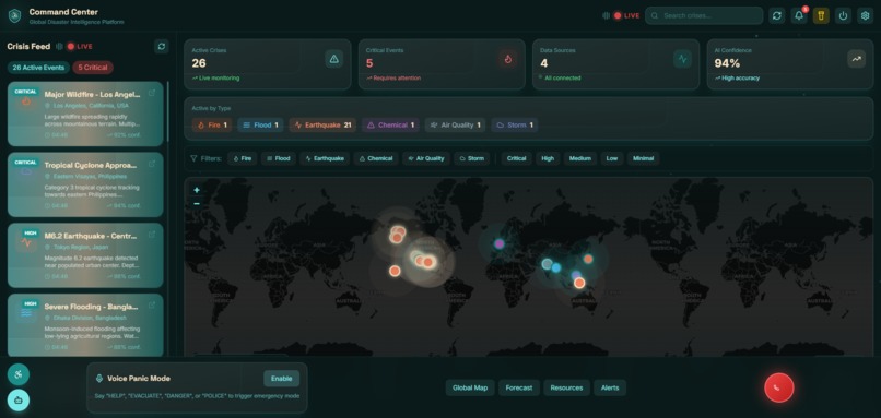
CrisisHelm is a real-time AI-driven disaster response platform that detects emergencies the moment they begin by analyzing live news streams, satellite fire data, earthquake feeds, and environmental signals. It automatically maps danger zones, identifies nearby hospitals and shelters, predicts how the crisis will evolve over the next hour, and guides people toward safety using dynamic routing and emergency instructions. The system connects users to their country’s emergency helplines and even supports one-tap SOS calling, ensuring that help is never more than a touch away. CrisisHelm doesn’t just react—it forecasts, analyses, and proactively protects.
We built CrisisHelm using a layered architecture that combines live data ingestion, a multi-agent AI engine, and a reactive, animated interface. Our ingestion pipeline gathers real-time information from Google News RSS, OpenAQ, NASA FIRMS, USGS, NOAA, and geolocation APIs, merging these sources into a unified crisis timeline. On top of that, we designed five cooperating AI agents: a Detection Agent for identifying disasters through NLP and vision, a Mapping Agent for geofencing and hazard modeling, a Resource Agent for locating help nearby, a Coordinator Agent for generating actionable plans, and a Forecast Agent capable of simulating the next 60 minutes of crisis progression. Finally, we built a visually rich, interactive frontend using Mapbox/Leaflet with glowing markers, live overlays, drone-style telemetry, and animated emergency transitions that keep the interface alive and reactive.
Building CrisisHelm came with its share of challenges. The biggest hurdle was ensuring the system never displayed a blank or empty state—real-time data APIs fail unpredictably, formats are inconsistent, and latency can break the experience. We had to engineer robust fallback systems and offline-first logic to guarantee that maps, CCTV feeds, drone views, and prediction panels always show meaningful information. Another challenge was blending smooth UI animations with real-time data streams without sacrificing performance. Designing predictions that felt believable and useful required careful modeling, and integrating multiple global disaster feeds into one unified view demanded significant data handling rigor. But each challenge pushed us to think deeper and engineer smarter solutions.
Despite the complexity, we are incredibly proud of what we built. CrisisHelm successfully brings together multiple live data sources, intelligent agents, predictive modeling, emergency routing, helpline automation, and a polished UI into a single cohesive system. We created a platform that genuinely feels like a modern command center—reactive, intelligent, and purpose-driven. The 60-minute future simulation, the ability to map danger zones instantly, and the smooth, animated interface feel like features from the next generation of emergency technology.
Throughout this journey, we learned how to handle high-frequency crisis data streams, how to design multi-agent architectures that communicate effectively, and how to balance performance with visually rich features. We also explored geospatial AI, real-time risk propagation modeling, and the importance of human-centered design in emergency tools. Even LaTeX-based modeling helped us formalize hazard propagation, for example:
Rnext=Rcurrent+(W⋅Vwind)−(E⋅Ssafety)
highlighting how environmental variables shape risk.
Looking ahead, CrisisHelm has an exciting future. We plan to integrate real autonomous drone scouting, multilingual voice assistants, government emergency network connections, evacuation crowd-flow prediction, and a mobile offline version for disaster zones with weak connectivity. We also aim to expand CrisisHelm into a professional version for emergency responders and NGOs, pushing it toward real-world deployment where it can save lives at scale.
CrisisHelm started as an idea—but today, it feels like a glimpse into the future of disaster response. And we’re just getting started.
Built With
- and-custom-forecasting-scripts-for-simulating-risk-propagation-over-time.-we-integrated-multiple-free-and-open-data-apis-to-power-real-time-intelligence?google-news-rss-for-disaster-headlines
- and-enforcement-records-using-firebase/supabase
- and-ipapi-for-geolocation-based-emergency-routing.-the-system-stores-event-logs
- and-mapbox/leaflet-to-render-dynamic
- and-multi-agent-ai-frameworks.-the-frontend-is-powered-by-javascript
- and-progressive-data-loading-to-maintain-60fps-performance-even-during-peak-activity.-crisishelm-is-ultimately-a-fusion-of-modern-web-development
- and-real-time-api-aggregation
- and-webrtc/rtsp-handlers-for-cctv-and-drone-stream-processing.-the-entire-platform-is-deployed-on-the-cloud-using-vercel-and-render-for-scalable-hosting
- api
- base44
- css
- data-fusion
- drone-telemetry
- emergency-informatics
- ensuring-reliable-persistence-across-user-sessions.-we-also-used-three.js-for-3d-hazard-reconstruction
- geospatial-mapping
- googlenews
- gpu-accelerated-rendering
- html5
- including-yolo-for-vision-detection
- interactive-geospatial-visualizations-with-smooth-neon-animations-and-crisis-overlays.-for-the-backend
- javascript
- lightweight-nlp-transformers-for-crisis-interpretation
- nasa-firms-and-sentinel-hub-for-satellite-fire-and-vegetation-data
- natural-language-processing
- noaa-for-wind-field-analysis
- node.js
- open-meteo-for-weather-and-wind-patterns
- openaq-for-live-air-quality
- predictions
- python
- react
- real-time-data-engines
- rss
- satellite-intelligence
- supported-by-websockets-for-pushing-live-alerts-and-sensor-updates-directly-to-the-interface.-our-ai-agents-rely-on-python-based-models
- usgs-for-earthquake-events
- we-used-node.js-and-express-to-handle-routing
- webar-frameworks-for-ar-crisis-overlays
- with-optimizations-handled-through-web-workers

Log in or sign up for Devpost to join the conversation.