-
-
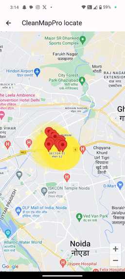
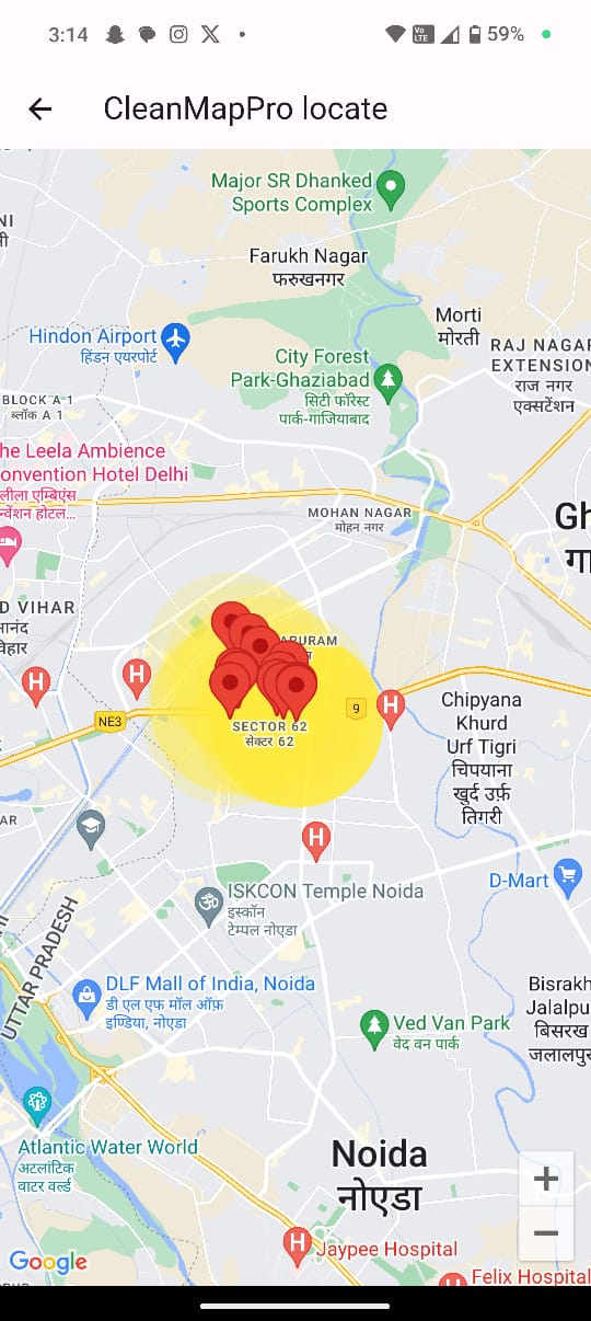
High Waste Area Mapping
-
Advanced Image Processing
-

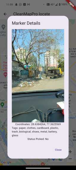
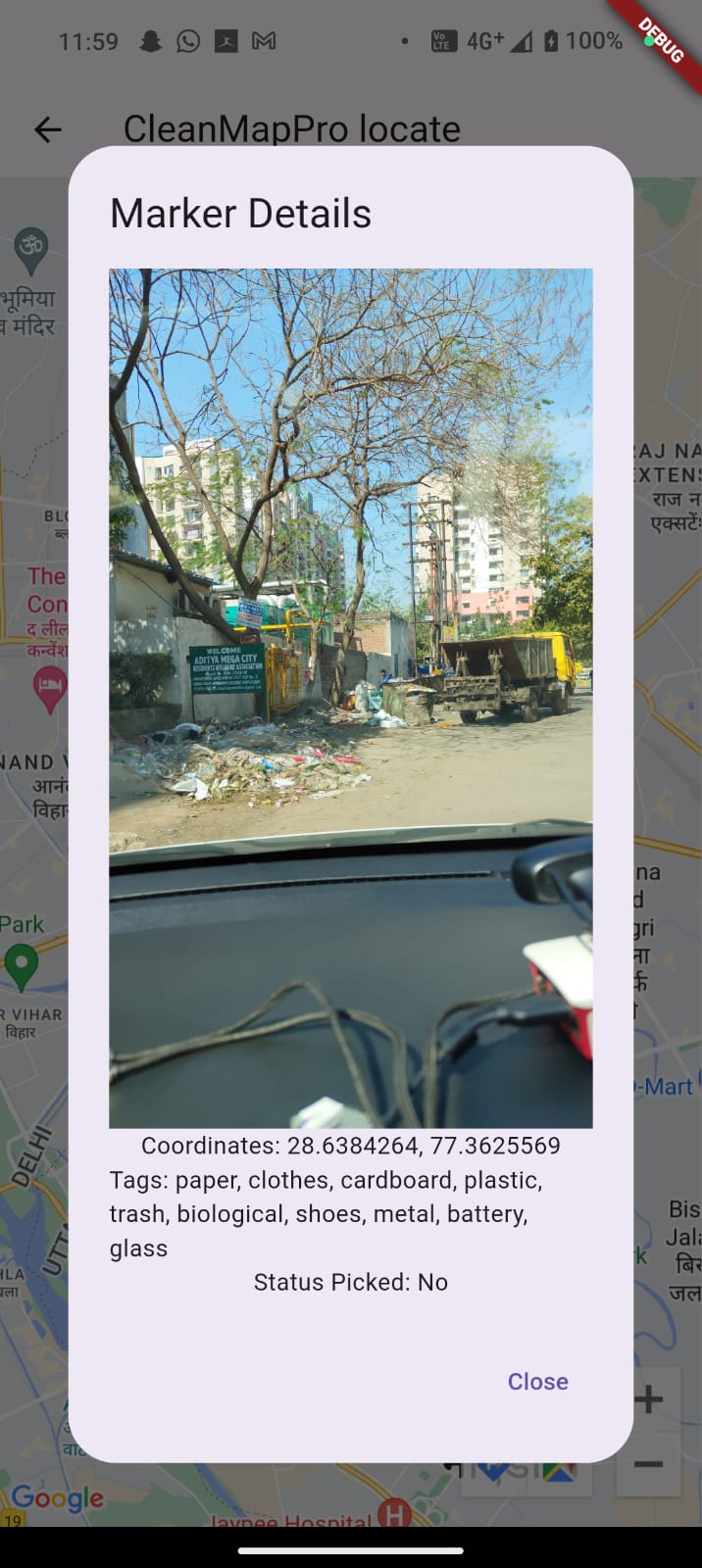
Geo-Location Tagging
Inspiration
Urban areas face significant challenges in efficiently managing waste due to difficulties in identifying and prioritizing waste hotspots. Traditional methods are often resource-intensive and inefficient, leading to unsanitary conditions and public health issues. The World Bank highlights that over 50% of urban waste is improperly managed. Innovations like smart waste systems, sensors, and data analytics are key to enhancing efficiency and ensuring sustainable urban environments.
What it does
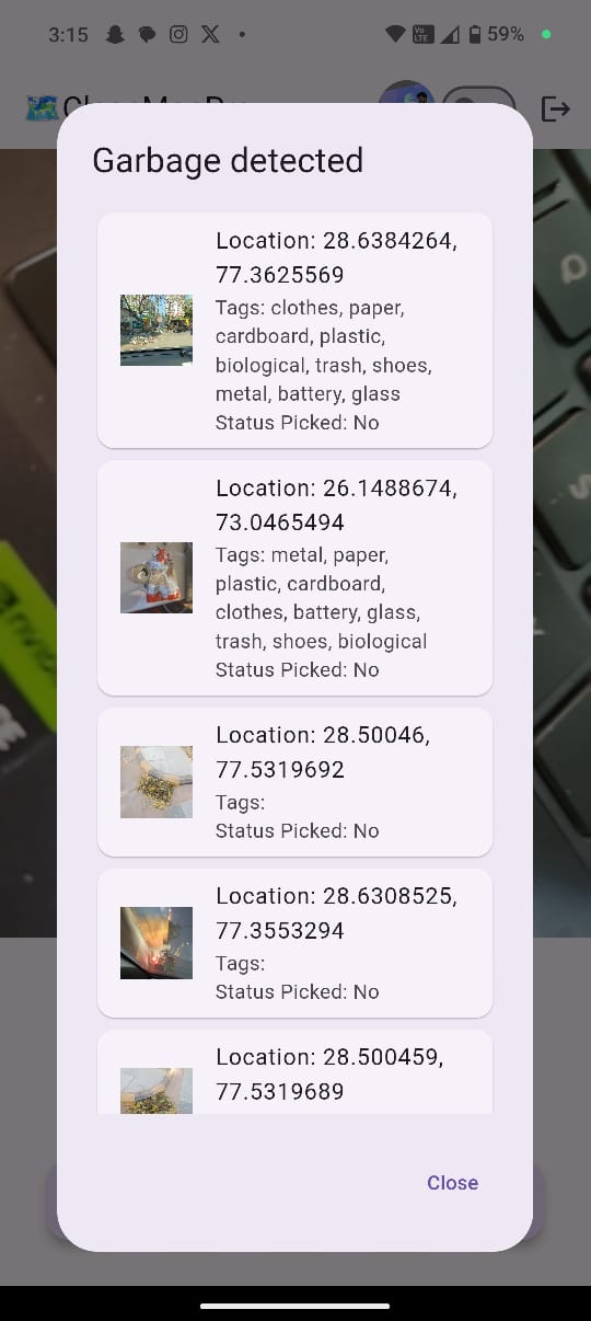
"Geo Tracking of Waste" offers a tech-driven approach to urban waste management. It utilizes cameras mounted on government or public vehicles to capture and analyze footage, detecting waste throughout the city. This innovative system ensures real-time identification and precise geo-location tagging of waste, facilitating prompt and efficient cleanup operations.
Key Features:
- Real-Time Waste Identification: Cameras capture city-wide footage, identifying waste hotspots in real time.
- Geo-Location Tagging: Captured images include exact geo-location data, pinpointing the locations of waste.
- High Waste Area Mapping: The system visually maps areas with significant waste accumulation.
- Advanced Image Processing: Employs a neural network for quick and accurate detection of waste.
- Cost-Effective Hardware: Provides affordable Arduino-based solutions for geo-location tracking, capable of offline data storage.
How we built it
We built "Geo Tracking of Waste" through a systematic approach:
Research and Planning: We conducted thorough research to understand the challenges in waste management and identified the need for a technology-driven solution. We outlined project goals, requirements, and technical specifications.
Algorithm Development: Our team of data scientists and engineers developed object detection algorithms using machine learning and computer vision techniques. We trained the algorithms on diverse datasets to accurately identify waste in urban landscapes.
Hardware Design and Integration: We designed a modular camera mounting system compatible with municipal vehicles. Through multiple design iterations and prototyping, we ensured a secure and adaptable solution for capturing waste data.
Data Management Implementation: To address data transmission challenges, we implemented an offline storage system within our devices. This ensured data integrity and allowed for later synchronization when internet connectivity was available.
User Adoption Strategy: Recognizing the importance of user adoption, we created user-friendly manuals and conducted training sessions for municipal workers. This facilitated the seamless integration of our system into their daily routines.
Testing and Iteration: We rigorously tested our system in real-world urban environments, refining algorithms and hardware components based on feedback and performance evaluations.
Collaboration and Feedback: Throughout the development process, we collaborated with waste management experts, municipal authorities, and community stakeholders to gather insights and ensure alignment with user needs.
Challenges we ran into
In the prototyping phase of "Geo Tracking of Waste," we encountered various challenges that tested our resolve and ingenuity. The primary issue was refining our object detection algorithms to accurately identify waste in diverse urban landscapes, a task complicated by changing weather, lighting conditions, and urban clutter.
We tackled this by enhancing our machine learning models, incorporating a broader range of environmental conditions into our training datasets. By simulating different scenarios, including varying light and obstructions, we improved the model's robustness and accuracy.
Integrating our system with municipal vehicles was another significant hurdle. We needed a non-intrusive, yet secure camera mounting system that could adapt to various vehicle types. After multiple design iterations, we developed a modular mounting solution that could be easily customized for different vehicles.
Data transmission was also a challenge due to inconsistent internet connectivity. We overcame this by implementing an offline storage system within our Arduino-based devices, ensuring data integrity and later synchronization when the connection was available.
User adoption presented a non-technical challenge. We prepared for this by planning user-friendly manuals and training sessions to facilitate the integration of our system into the workers' routines.
These challenges, while daunting, provided valuable learning experiences. As we prepare to seek funding and guidance at the hackathon, we believe the hurdles we've overcome have only served to refine our vision and demonstrate our commitment to creating a viable, scalable solution for waste management. We're eager to receive expert feedback, secure the necessary resources to scale our prototype, and make "Geo Tracking of Waste" an indispensable tool for cities worldwide.
Accomplishments that we're proud of
This solution revolutionizes urban waste management by offering accurate, real-time data on waste accumulation. It saves time and resources and significantly improves urban cleanliness and health.
What we learned
- Efficient Waste Management: Streamlines the process of identifying and cleaning up waste.
- Strategic Planning: Assists in resource allocation and operational planning for municipal authorities.
- Enhanced Public Health: Timely waste removal leads to cleaner, healthier urban environments.
- Safety Enhancements: Includes additional features for road safety and occupant protection.
What's next for Clean Map Pro
Integration with Smart City Infrastructure
To make the app multilingual for the Indic region.
To navigate through a website using an AI assistant.
Expansion to Recycling and Resource Recovery
Built With
- androidapps
- api
- cognitive
- deeplearning
- django
- google-maps
- imagedetection
- kotlin
- machine-learning
- neuralnetowrks
- python
- raspberry-pi
- yolo


Log in or sign up for Devpost to join the conversation.