-
-

logo
-
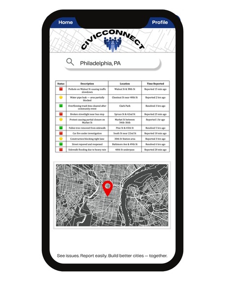
mobile version
-
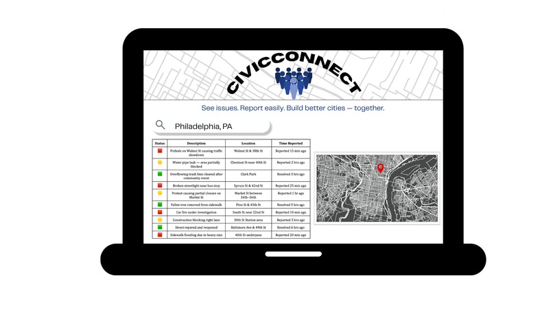
desktop version


Ideathon Category
Inspiration
At my university, there’s a system called PublicAlert that notifies students and faculty about emergency situations such as thefts, attacks, or severe weather alerts. It made me realize how powerful real-time communication can be for keeping communities informed and safe. But I often wondered — what if we had a similar system for everyday civic issues?
In Philadelphia, there have been many instances where I wished for this kind of transparency. Roads suddenly close due to construction or accidents, water main breaks cause flooding, trash piles up after events, or protests disrupt public transportation, and most people only find out after they’re already affected. I still remember one evening when a car caught fire near campus, and no one nearby was notified until smoke filled the area. Another time, after heavy rain, several streets and sidewalks became impassable, leaving people stranded or forced to walk dangerously close to traffic.
These aren’t emergencies in the traditional sense, but they impact daily life in very real ways. A simple, location-based alert and reporting system could help citizens stay aware, avoid potential hazards, and even assist one another before problems escalate.
What it does CivicConnect is designed as a community-driven reporting and alert platform. Users can: • Report issues by uploading a photo or short video, tagging the exact location, and writing a brief description. • Filter reports based on proximity, as close as 0.5 miles, or as wide as 10 miles, depending on what’s relevant to them. • Track updates on city maintenance, closures, or resolutions, and receive notifications when something changes. • Interact and contribute, people can add additional information, confirm ongoing issues, or mark them as resolved once they’re fixed.
For example, if there’s a pipe leak on Walnut Street, a user could immediately report it with a picture and location tag. Nearby users would get an alert within a 0.5-mile radius. The local authorities could update the status, “repair scheduled for 3:00 PM”, and once completed, mark it as resolved with a timestamp. This same process could apply to things like protest activity, road closures, damaged streetlights, or overflowing trash bins.
How It Works Crowdsourced Reporting: Citizens act as the eyes and ears of the city. Every submission becomes a data point visible on the community map. Geolocation Filters: Users can personalize their feed to see issues within their chosen radius, ensuring relevance. Verification Layer: City authorities or verified volunteers can confirm the authenticity of a report. Status Tracking: Reports progress from “Submitted” → “In Review” → “In Progress” → “Resolved,” creating transparency. Community Insights: Aggregated data can help identify recurring problem areas — for instance, intersections that frequently flood or areas with recurring waste disposal issues.
Impact CivicConnect aims to close the communication gap between citizens and local governments. It transforms individual frustration into collective action — empowering residents to participate in improving their city while giving authorities clear, actionable data. By combining real-time community input with location-based technology, this system can reduce misinformation, improve trust, and help create more responsive and accountable city management.
Built With
- canva
- descript
- googledoc
- youtube


Log in or sign up for Devpost to join the conversation.