-
-

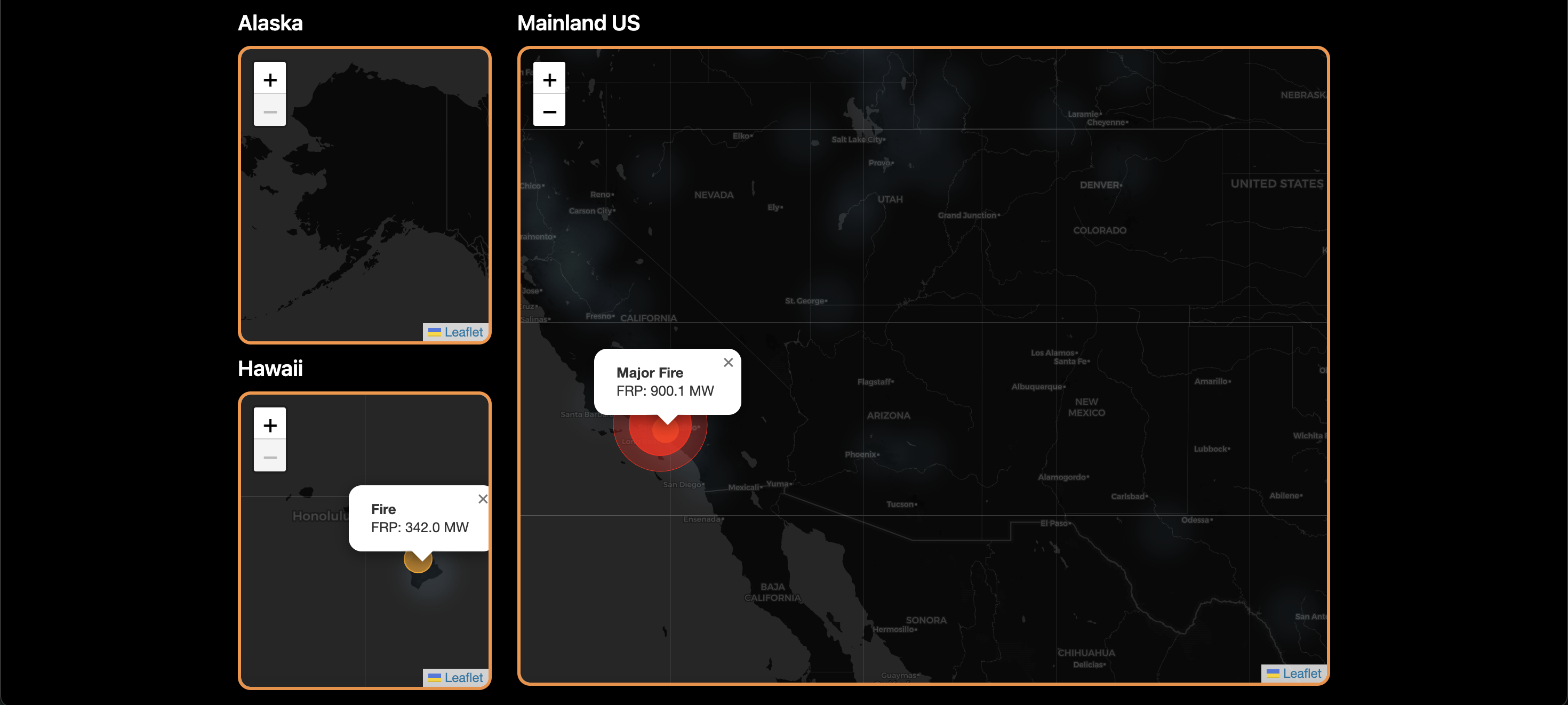
Interactive mapping software (using Leaflet.js) that represents current fires and active warnings.
-

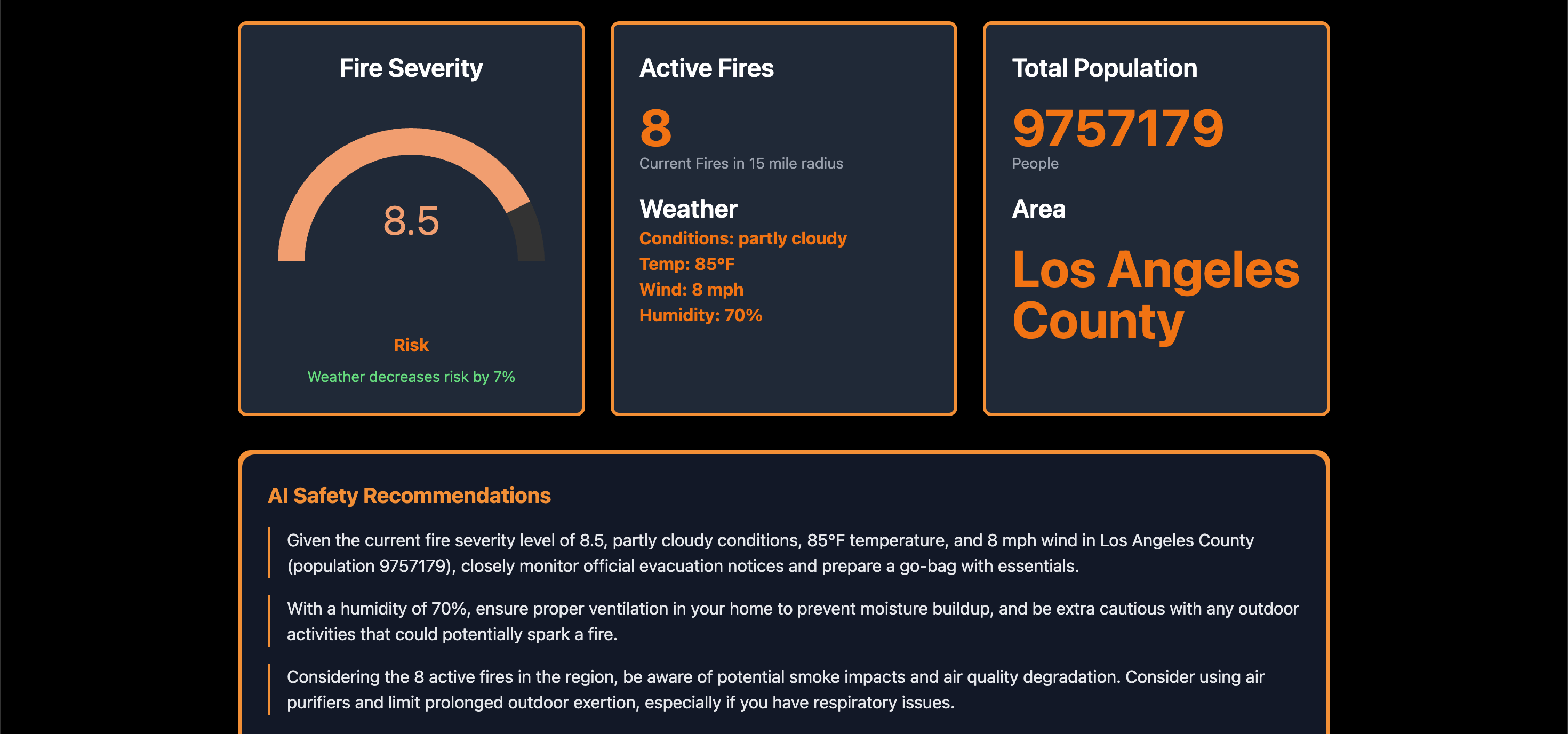
The dashboard that can track weather information using OpenWeatherAPI, population using US Census, and Google Gemini recommendations.
-
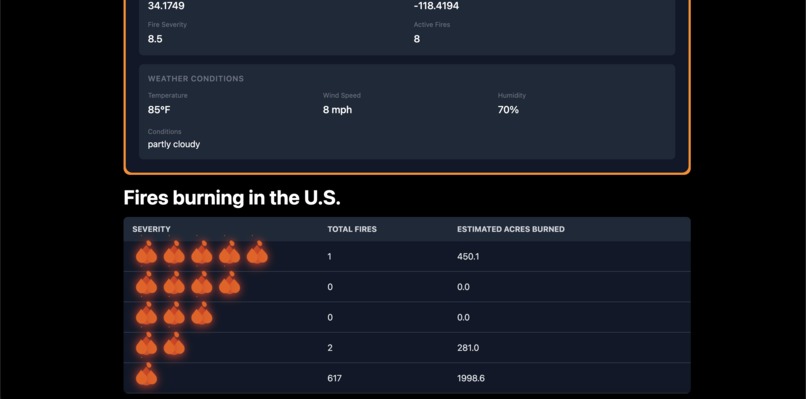
Active fires and locations. This tracks the current fires happening by magnitude and acres burned. The report button allows user input.

🌟 Inspiration
We were inspired to create Catalytica after witnessing the increasing destruction caused by wildfires across the United States. Entire ecosystems, communities, and families have been devastated by these disasters. The fire in Estacada, Oregon recently hit close to home, affecting our family members. We wanted to build something that informs and protects, providing a solution that gives people real-time data and AI-powered safety tips to stay safe.
🔥 What It Does
Catalytica is a wildfire intelligence dashboard that provides:
🗺️ Real-Time Fire Insights
- Live heatmap of active fires in all 50 states
- Fire severity tracking using NASA FIRMS data
- Community fire reporting based on your location
🌡️ Environmental Monitoring
- Real-time weather (temperature, wind speed/direction, humidity)
- Environmental overlays to assess how weather may impact fires
👥 Population Impact Analysis
- Population data via the U.S. Census API
- Fire radius-based affected area calculation
- County and region identification
🤖 AI-Powered Safety Recommendations
- Dynamic advice generated with Google Gemini AI
- Custom tips based on:
- Fire severity
- Weather conditions
- Population density
- Fire count and proximity
- Geographic location
- Fire severity
🛠️ How We Built It
We used a modern tech stack to bring Catalytica to life:
- Frontend: React + TypeScript
- Backend: Firebase (Firestore, Functions, Hosting)
- Mapping: Leaflet.js
- Styling: TailwindCSS
- APIs:
🚧 Challenges We Ran Into
- Setting up Firebase functions as first-time users
- Parsing and syncing multiple API responses into our UI
- Building a fire severity algorithm using FRP and weather factors
- Accurately calculating proximity and impact zones
- Handling merge conflicts and switching to Context + Reducer for global state
- Overlaying dynamic fire for heat mapping on the Leaflet map
🏆 Accomplishments We're Proud Of
- Successfully integrated real-time satellite data from NASA FIRMS
- Created a smooth and interactive dashboard interface
- Built a reliable system to calculate population impact
- Developed AI-generated safety tips tailored to real conditions
- Pushed through difficult bugs and unfamiliar tools as a team
📚 What We Learned
- How to work together effectively and split tasks in a fast-paced environment
- How to integrate and manage data from multiple APIs
- How to structure a full-stack app using Firebase
- How to prompt Google Gemini AI for meaningful, contextual output
- How to design a scalable system with efficient state management
🚀 What’s Next for Catalytica
- Develop a mobile app version
- Add push notifications for nearby fires and evacuation alerts
- Expand to support global fire data
- Improve AI-based fire spread predictions based on reports
- Add more robust community-driven fire reporting
- Integrate with emergency services for faster response coordination
Built With
- backend
- census
- firebase
- gemini
- geocoding
- leaflet.js
- mapping
- nasa
- openweather
- react
- tailwind
- typescript


Log in or sign up for Devpost to join the conversation.