-
-
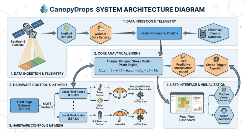
architecture
CanopyDrops
Inspiration
Climate change and rising global temperatures pose an existential threat to coffee cultivation, particularly Arabica beans, which require strict microclimatic conditions ($18\text{–}21^\circ\text{C}$) to thrive. In arid and expanding desert environments, extreme solar radiation causes severe heat stress and water loss. We were inspired by native desert flora that use structural shade to survive harsh conditions, and we asked ourselves: What if we could bring dynamic, smart shade to vulnerable agricultural fields using space-age telemetry? This led us to develop CanopyDrops—a blend of space technology, IoT robotics, and sustainable agriculture.
What it does
CanopyDrops is an end-to-end precision agriculture platform designed to protect fragile desert coffee crops from heat stress while drastically lowering water usage. The system integrates four core elements:
- Satellite: Retrieves high-resolution thermal infrared and NDVI (Normalized Difference Vegetation Index) data to track crop stress and soil moisture continuously across large surface areas.
- Coffee: Specifically targets delicate coffee microclimates, maintaining optimum canopy temperature and preventing coffee berry loss.
- Umbrella: Controls autonomous, solar-powered kinetic shade arrays (resembling umbrellas) that open or close dynamically over crop lines depending on real-time solar intensity.
- Desert: Solves the core challenge of extreme evaporation and ground degradation in arid, desert agricultural zones.
When satellite telemetry detects a thermal spike over a targeted grid, local canopy sensors evaluate the ambient temperature $T_{\text{ambient}}$ and solar irradiance $I$. If the heat index exceeds a safe threshold, the kinetic umbrella structures automatically deploy, reducing leaf-surface temperatures by up to $8^\circ\text{C}$ and drastically lowering evapotranspiration rates.
How we built it
We built CanopyDrops using a hybrid software-hardware architecture:
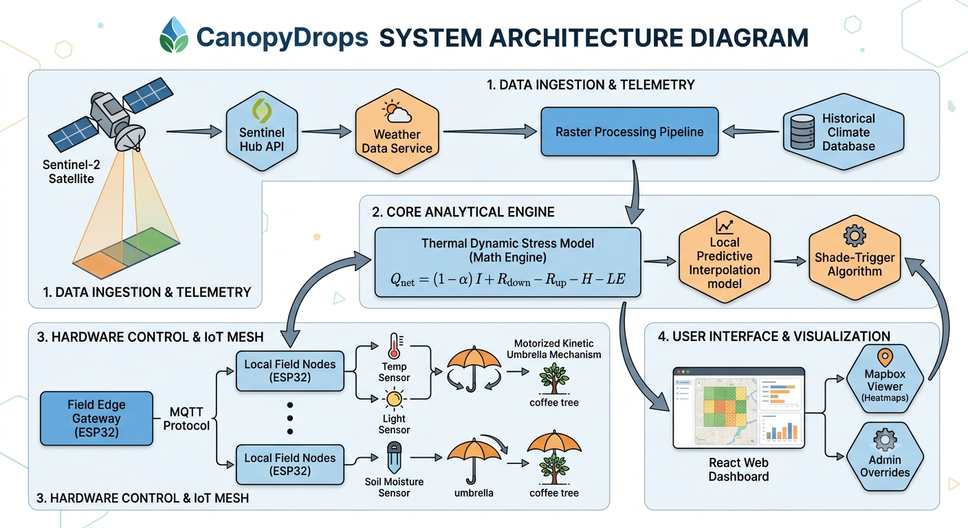
- Data Ingestion & Telemetry: We developed a processing pipeline to pull spatial raster datasets (simulating Sentinel-2 satellite imagery) and feed surface reflectance data into our core analytical engine.
- Microclimate Algorithm: We modeled thermal dynamic stress using heat energy equilibrium equations:
$$Q_{\text{net}} = (1 - \alpha) I + R_{\text{down}} - R_{\text{up}} - H - LE$$
Where $\alpha$ represents crop albedo, $I$ is incoming shortwave solar radiation, $H$ is sensible heat flux, and $LE$ is latent heat flux (evapotranspiration). The algorithm deploys shade to artificially adjust $I$, conserving soil moisture $LE$.
- Hardware Prototype & Control System: We assembled an IoT mesh network using ESP32 microcontrollers connected to ambient temperature, light (LDR), and soil moisture sensors. A motorized kinetic umbrella mechanism receives state commands via MQTT to open or close based on trigger thresholds.
- Dashboard & Visualization: Built a React web dashboard coupled with a Mapbox viewer to map field grids, show satellite heatmaps, and allow farmers to override umbrella states manually.
Challenges we ran into
- Data Latency Alignment: Satellite revisit times can lag behind rapid real-time temperature fluctuations. We had to build a predictive interpolation model running on local edge nodes to bridge the gap between periodic satellite passes and immediate weather spikes.
- Mechanical Kinetic Design: Designing an umbrella mechanism robust enough to handle high desert winds while remaining lightweight and low-power required multiple CAD iterations and gear ratio calibrations.
- Power Optimization: Balancing motorized mechanical deployment with solar panel storage on rural edge nodes required strict power-sleep cycles for the onboard microcontrollers.
Accomplishments that we're proud of
- Successfully linked macro-level spatial data (satellite passes) with micro-level physical actuators (umbrella microcontrollers) in real time.
- Built a working hardware prototype that deploys automatically when simulated solar irradiance crosses critical heat thresholds.
- Created a mathematical model demonstrating a potential 30–40% reduction in irrigation water loss through dynamic canopy shading.
What we learned
We gained deep insights into precision agriculture physics, spatial telemetry APIs, and embedded system design. Crucially, we learned how to transform four seemingly disconnected concepts—Coffee, Satellite, Desert, and Umbrella—into a single, cohesive climate-tech solution with genuine real-world application.
What's next for CanopyDrops
- Machine Learning Microclimates: Train predictive neural networks on historical weather patterns to deploy shade proactively before heat spikes occur rather than reactively.
- Agrivoltaic Integration: Replace standard umbrella canvas materials with flexible, lightweight solar panels to generate off-grid power for local farm equipment while shading the crops.
- Pilot Testing: Partner with high-altitude arid agricultural researchers to deploy physical test arrays over active coffee crops.
Built With
- arduino
- autodesk-fusion-360
- c++
- docker
- esp32
- express.js
- firebase
- github
- javascript
- leaflet.js
- mapbox
- micropython
- mqtt
- node.js
- numpy
- pandas
- python
- react
- sentinel-2-api
- solidworks
- tailwind-css
- vercel


Log in or sign up for Devpost to join the conversation.