-
-
Buzzline Emergency Response
Inspiration
With two of our team members living near LA, we really felt the heat of the wildfires. As we worried for our family and our friends at UCLA, the urgent need for real time, data backed emergency solutions became much more apparent, and sparked our passion for building this tool.
What it does
Buzzline is your lifeline during a crisis. Here are a few of the features if offers:
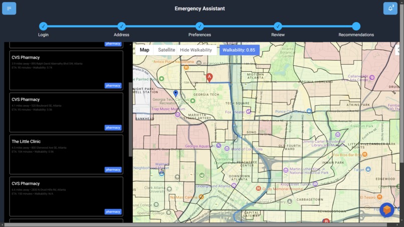
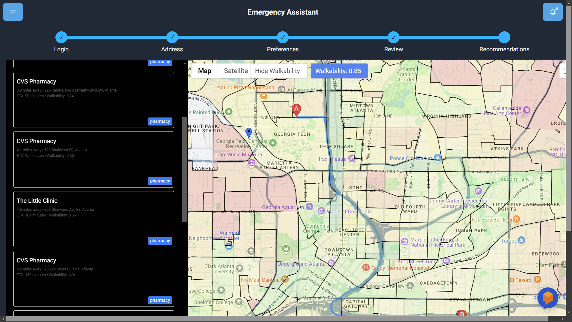
Real Time Mapping - Our app integrates with Gemini, Google Maps, and help what did we use for fire in order to give you real time mapping of fires and directions that avoid the fires.
Personalized Amenity Recommendations - Through the use of Gemini, we are able to take dynamic and custom information from the users and query Google Maps APIs through Gemini. The big advantage of this is Gemini is able to smartly create custom queries that best interest the user ever time, whereas other platforms use the same queries and are not nearly as personalized. This is further proven as Gemini gives reasoning for every amenity recommended as to why it chose it based on user characteristics.
Custom Walkability Metric - During a crisis, being able to easily walk to areas is incredibly important, especially when there is a high chance of injuries. Our custom walkability metric is computed using gas this up and this is good because etc.
Custom Chatbot - During a crisis, being able to ask questions to a chatbot quickly is important, so we implemented a chatbot that users can use while using our service
How we built it
Next.js and Javascript
The core of our project is Next.js, to leverage both server-side rendering and dynamic routing. By combining Next.js with modern Javascript/React, we were able to easily construct a scalable and efficient platform, which is vital for streamlining emergency responses.
Google Maps API Services
Using AI-generated to create Google Maps Places API queries that fit YOUR background, we build a roster of highly-applicable and immediately available resources; using Google Maps Routes API, we help you stay safe by visualizating various routes that avoid fires to get you safely from point A to B!
Gemini AI API
We chose to directly integrate Gemini API into our Next.js client to optimize the user experience and service speed; generating custom API queries to personalize amenity recommendations, creating data summaries of the user's background, and dynamically filtering results for effective UI.
Our most unique use of Gemini AI API comes in the form of generating custom queries. Provided with key details of the user's unique circumstances (and priorities), we prompted Gemini AI to generate custom queries specifically for Google Maps APIs to streamline this process. Gemini was able to acquire relevant search results much quicker than static queries (e.g. presenting desires results rather than relying on the user to sort through large results. With transparency in mind, Gemini also provides explanations for why it queried for each location it chose.
Google Dialogflow
We integrated Google Dialogflow to build a custom fire emergency chatbot to assist distressed users organize their thoughts and reach emergency services. This dialogflow agent was trained on handling fire crisis related scenarios, allowing users to ask questions 24/7 and get immediate replies, providing much-needed emotional and disaster-response resources.
Google OAuth & Firebase
We implemented Google OAuth because we wanted an easy way for users to sign in and an easy way for us to store data, which leads to Google Firebase. We were able to create a Firebase Cloud Firestore database, which allows us to create a 'collection' of uses, where each user is a unique document that is tied to their OAuth Account, allowing us to maintain unique data for each user.
Google Cloud Platform (GCP) Buckets
We used GCP buckets to manage geospatial data that was necessary for implementing custom walkability metrics into our project. A large reason we chose GCP buckets was due to the high scalability and availability of buckets, making them an obvious choice especially with our interest in efficiency.
Challenges we ran into
Some challenges we ran into were creating safe routes from point A to B and avoiding real-time fires, as Google Maps APIs allow optimized routing but not around specific pre-defined areas. We addressed this by integrating the opensource OpenRouteService API into our workflow, which allows us to generate routes that circumvent certain geometries; we then create a circular polygon to avoid around each satellite-detected fire!
Accomplishments that we're proud of
We are especially proud of the complex API chaining between calling the Gemini API and Google Maps APIs. While it was very complex, it was worth it because lead to a great deal of customization and personalization.
What we learned
While working on this project, we realized the vast potential of Google APIs, from Maps to Places to Oauth (and of course many others), and that there are almost endless possibilities for creating unique and creative applications. Especially chaining multiple APIs together was really cool as we got to transform raw data into insights that are actionable and lead to personalization. Furthermore, getting to work with Gemini API was also eye-opening as the ability to generate custom queries added a whole new aspect of using AI to introduce adaptability and custom abilities into our applications.
What's next for Buzzline
We still want to continue this project onwards, pushing the boundaries of combining Google APIs and Gemini to enhance real time mapping of fire crisis and personalization to evacuations. A rough roadmap includes deepening the integration of Gemini AI to create even more sophisticated and context-aware responses. We also plan on incorporating user feedback into our app to find more ways to make it better. We were also able to implement the Pedestrian Environmental Index, as published by the University of Illinois, Chicago as a measure of pedestrian walkability! We thought this would be especially applicable to those suddenly having to flee fire hazards. We were able to implement an overlay of this metric at the Census Block Group-level in our local city Atlanta, GA; we are very easily able to build it for the entire U.S., but doing so for just a city takes at least a couple of days (too long for this hackathon!) After computing, we will overlay this graph in our service to make it accessible for anyone. *The metrics for Atlanta, GA were pre-computed by a research team in the Georgia Tech, Sustainable Urban Systems Lab; made available for others to use! Thank you to the GaTech SUSL!
Pedestrian Environmental Index research paper: https://www.sciencedirect.com/science/article/pii/S0966692314001343

Log in or sign up for Devpost to join the conversation.