-

-
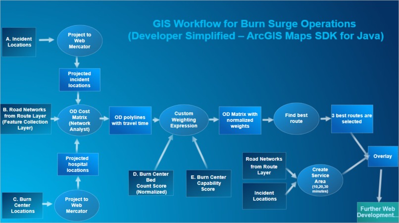
Simplified GIS Terminology through the SDK

Inspiration
Serious burn injuries standalone in magnitude, exercising physical, emotional, and clinical devastation. A moderate burn injury requires a staff of over 50 and an extremely precise environment to keep the patient stable over multiple months. The economics of this clinical reality lead to Burn Centers serving astronomically large geographic areas which derives a surge/disaster planning model where Burn Centers and professionals are forced to run never-ending general surgical and clinical training classes at various hospitals.
Currently Burn Centers go down an arbitrary list of thousands of hospitals and run very general drills. Our Goal is to provide a planning tool that incorporates geographic and historical knowledge to provide extremely specific directives and action items to maximize the very limited time of the only 300 burn surgeons and 300 burn nurses in the country.
In addition, LA County is pioneering the Burn Resource Center Program, where non-specialized Burn Centers can sign a contract with the County to receive extra funding and specialized training, tools, and equipment and in return they maintain the ability to staff a Burn Patient for 72 hours by participating in continuing education and accreditation protocols and audits.
What it does
The application lets users select from prebuilt scenarios, select hospitals to include in the routing analysis (to simulate hospitals being unavailable due to disaster or evacuation), run a routing analysis based on a custom cost function, display the top three potential hospital assignments and corresponding score, allow the user to toggle on drive-time service areas from the incident and a general non-burn ready hospital layer to analyze what hospitals can be potentially converted into Burn Resource Center
We are making a web application to enhance the drills and disaster exercises that Burn Centers and County EMS's (specifically Orange County, Los Angeles County, Riverside County, and San Bernardino County) run through. Our application will match and score patient -> hospital routes based on route times and other attributes like total burn surface area, hospital capability, pediatric capability, bed count score, and patient criticality levels. Then, the application will generate a report with directives. Based on hospital capabilities, the information in this report should feature a few areas of improvement for the treatment centers. For example, a hospital that may have faced evacuations in the past should do a simulation with a possible farther away center in case of emergencies or unexpected evacuation orders. The app will help run monthly disasters, burn event simulations and make an action plan for outreach. Making split-second decisions involving multiple factors is challenging without a well-prepared methodology in place.
How we built it
We built the application using the ArcGIS Maps SDK for custom webGL layer views, service area analysis, FastAPI to hook up the LLM report generator. The application features many GIS tools commonly used in ArcGIS Pro, like Service Area Rings and Network Analyst methods.
Challenges we ran into
While our team had great collaboration efforts, it was still challenging to work with individuals whose skills do not overlap. This unexpected road bump led to additional discussions and required expert planning in the beginning of our brainstorming sessions to understand the abilities of our team members. In turn, we collaborated with compassion and empathy and produced a product we are proud of.
Accomplishments that we're proud of
We are incredibly proud of the custom weights in our scoring system, as well as its impact on varying routes for different adult and pediatric scenarios. This application can help aid our local community and we are deeply committed to helping Southern California after the devastating fires in 2025.
What we learned
Many of our team members developed professional skills in other areas than our own disciplines. For example, some of the developers gained a deeper understanding of GIS principles while our geographer grasped the integration of the Java SDK. Additionally, the entrepreneur brought amazing marketing tactics to our team that integrated both the GIS and Development vision to pitch the application. We all learned from one another, which highlights the importance of working with different people from different backgrounds.
What's next for Burn Surge Ops
In the near future, we would like to contact professionals in the burn response scientific community to help refine our weight and scoring systems. We would also like to provide these maps to the local Southern California area in hopes of aiding potential evacuation transfers and upskill accreditation possibilities.


Log in or sign up for Devpost to join the conversation.