Inspiration
Our project, Bike or Drive, was created to promote efficient transportation by either biking or driving to a location. Many times, it is difficult to drive around in a narrow, busy area with a lot of people and traffic, such as a college town. As we're sure you know, traffic sucks, and one of the reasons for this is that people take their car to go places where they really could just bike. This causes increased traffic and all the costs that come with it such as pollution and wear on city infrastructure. This program encourages people to bike by showing people that it would be faster to bike than to drive for many of their trips, which means less cars on the road which is good for everyone, from an individual and environmental standpoint.
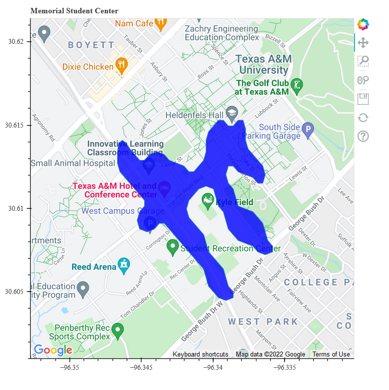
What it does
The idea is that users can input their location and destination in the program and an interactive map displays a polygon around the location. This represents the distances that the user can bike. Everything outside of the highlighted shape is recommended to travel by car.
How we built it
To build this program, our team used Google Maps Distance Matrix API, Python, Graph Hopper, and Bokeh libraries. Using the Google Maps API, we were able to extract the coordinates and use Graph Hopper to plot the points of the polygon. We then used the Bokeh Python library to display a map with the coordinates and polygon of biking distances. We mainly relied on the libraries for this program.
Challenges we ran into
The biggest challenges we faced are understanding and finding which libraries and tools we could use. Since our team was most knowledgeable in the Python language, we wanted to find technologies that worked well with Python. However, the graphing and web tools we searched were most compatible with Javascript or HTML, which we did not know how to use. Most of the time was spent researching mapping technologies and understanding the API. We also faced some challenges to find an appropriate biking distance since the API did not provide that information.
Accomplishments that we're proud of
We are most proud of being able to graph the coordinates on the map and display the polygon. After many trials and errors, the location was shown on the graph and an appropriate shape was highlighted, which moved with the map.
What we learned
We learned how to use Google Maps API in Python programming and the libraries involved in it. This was the first time using Google Cloud data for most of our teammates, so most of all it was a learning experience. After the project, we are decently familiar with new graphing libraries and how to implement them and may be able to make other projects using these skills.
What's next for Bike or Drive?
Although it is not officially done, we hope to test it out to see what we can tweak to make it the most effective for people traveling short distances. After testing and finalizing the program, we would like to make an official platform for this product, either a website or a mobile app in the future.

Log in or sign up for Devpost to join the conversation.