-
-
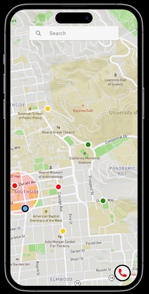
Berkeley WarnMAP UI

Inspiration
One common problem all Berkeley students face is fearing their safety when walking home at night. University students get Berkeley WarnMe emails, which are emails that report a crime on campus, very frequently. The problem is, most students see this email hours after the crime and are unaware of their position relative to where the dangerous area is.
What it does
The Berkeley WarnMAP app aims to keep university students safe on campus by alerting the user of a crime, mapping the locations of the crime, and buzzing when the user is in a mile radius of the crime.
How we built it
The Berkeley WarnMAP uses natural language processing (NLP) to extract the address of crimes from Berkeley WarnMe emails. The Google Maps API is used to plot the location on the map. A GPS tracker is used to locate the user's position relative to the crime.
Challenges we ran into
We had trouble implementing co:here's NLP API in the Berkeley WarnMAP.
Accomplishments that we're proud of
We are proud of successfully creating a visual of the Berkeley WarnMAP with interactive features.
What we learned
We learned more about implementing Figma, Node.js, and NLP through API interactions.
What's next for Berkeley WarnMap
In the future, we hope our app is able to expand to other college campuses around the country. Furthermore, we aim to complete the implementation of a user interface that is cross platform compatible with Flutter.


Log in or sign up for Devpost to join the conversation.