BASTION
Inspiration
The United States decommissioned its civil defense shelter system in 1994. The Cold War-era sirens are gone. The yellow-and-black shelter signs are gone. FEMA maintains no shelter database. There are zero designated nuclear shelters for American civilians in 2026.
We live near Hampton Roads, Virginia — home to Naval Station Norfolk, the largest naval base on Earth. That makes our neighborhood one of the highest-priority nuclear and drone targets in the Western Hemisphere. If an ICBM launched from Russia right now, we would have approximately 30 minutes. Thirty minutes with no sirens, no shelter signs, no app, no system of any kind telling 1.8 million people where to go.
The 2018 Hawaii false missile alert proved this: people received a push notification saying a ballistic missile was inbound, and they had absolutely no idea what to do. Parents were lowering children into storm drains. There was no plan.
Russia's war in Ukraine brought nuclear rhetoric back. The New START treaty expired with no replacement. North Korea unveiled 50 new nuclear-capable rocket launchers. Drone incursions over Joint Base Langley-Eustis made national news. The US military has extraordinary early warning capabilities (NORAD, SBIRS satellites) — but none of it faces civilians.
BASTION exists because this system should exist and doesn't.
What It Does
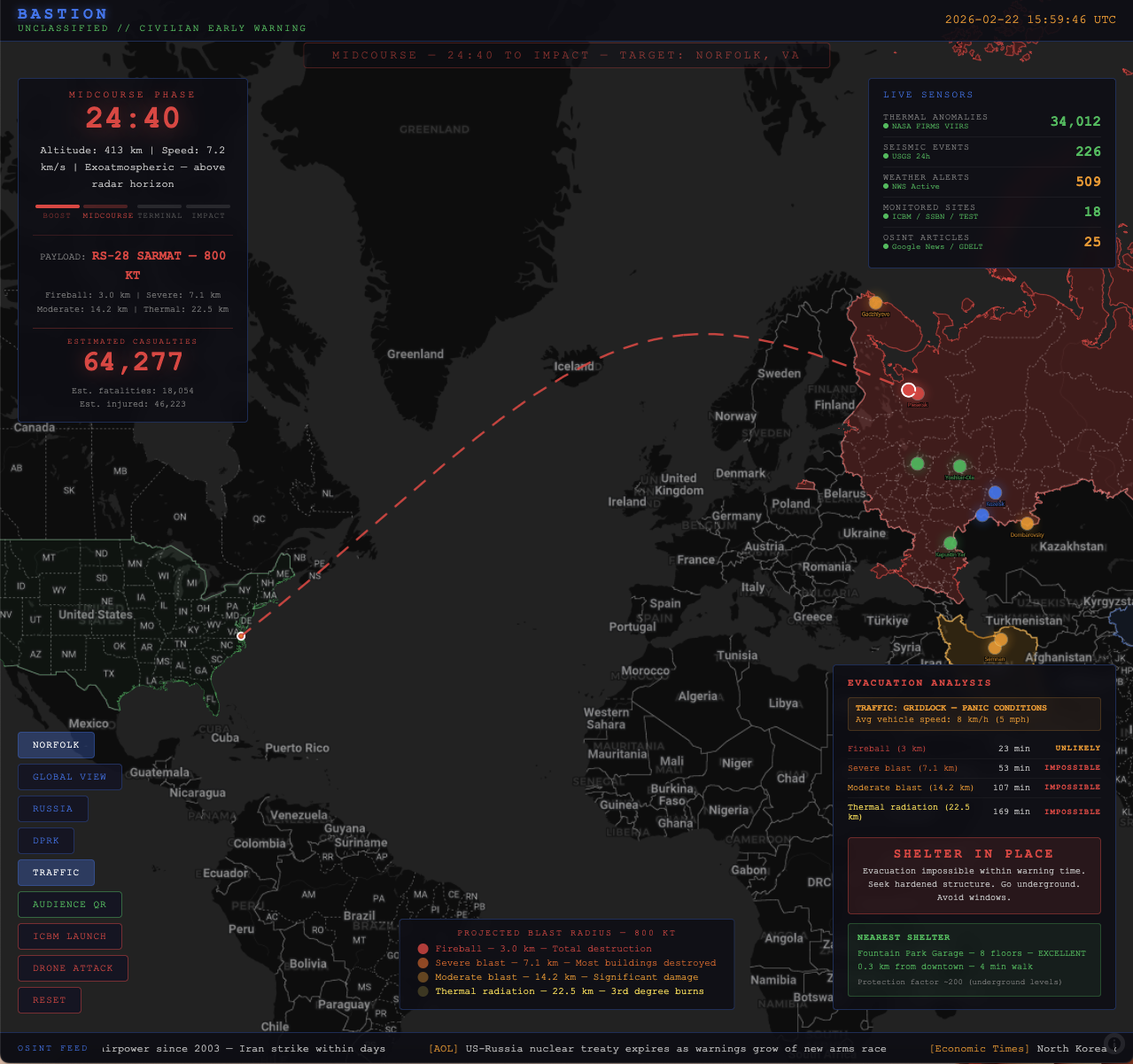
BASTION is a real-time civilian early warning and shelter navigation system with two components: a Command Center for threat monitoring and a Civilian Mobile App for individual shelter guidance, connected by a real-time sync server.
Real-Time Threat Detection via Open Data
BASTION fuses five categories of open-source intelligence:
- NASA FIRMS — Real-time thermal/infrared satellite data from VIIRS sensors. ICBM launches produce massive thermal signatures. We monitor 34,000+ global thermal anomalies continuously and correlate spikes near known launch sites.
- USGS Seismic Data — Nuclear tests and large launches produce seismic signatures. We correlate 226+ daily seismic events against known launch site coordinates.
- OSINT/GDELT News Feeds — Real-time news from Al Jazeera, Reuters, France 24, The War Zone, and others, monitoring for threat escalation signals. All headlines in the demo are real, recent articles.
- NWS Weather Alerts — 509+ active alerts affect fallout dispersion and evacuation routing.
- For Drone Threats — Civilian crowdsourced sighting reports, FAA NOTAM data, restricted airspace violation detection, and traffic camera anomaly detection.
The Command Center
A military-style HUD showing:
- 18 monitored launch sites across Russia (10), North Korea (2), China (4), and Iran (2) — all with real coordinates and weapons systems (Sarmat, Topol-M, Hwasong-17, DF-41, etc.)
- Country threat posture levels (GREEN/BLUE/AMBER/RED) with current intelligence
- Live sensor feeds: FIRMS thermal count, USGS seismic events, NWS alerts, OSINT article count
- Real-time scrolling news ticker with actual recent headlines
ICBM Simulation with Real Physics
- Plesetsk Cosmodrome → Norfolk = ~7,800 km, 30-minute real-time countdown
- Boost phase (0–5 min): altitude 0–400 km, speed ramping to 7.2 km/s, trajectory unknown — dashed arcs shown to 4 possible East Coast targets
- Midcourse (5–25 min): trajectory confirmed to Norfolk, exoatmospheric at 1,200 km altitude
- Terminal (25–29 min): re-entry, MIRV separation possible
- 800 KT blast radii (NUKEMAP-calibrated RS-28 Sarmat): fireball 3.0 km, severe blast 7.1 km, moderate 14.2 km, thermal radiation 22.5 km
- Casualty estimate: 307,000 dead / 786,000 injured
- Evacuation analysis proving driving is IMPOSSIBLE: at 8 km/h gridlock speed, you cannot escape ANY blast zone in 30 minutes
- Google Maps live traffic overlay auto-activates during launch
Drone Attack Simulation
- 4 restricted airspace zones (Naval Station Norfolk, Naval Shipyard, Norfolk Intl Airport, Langley-Eustis)
- 3 tracked UAS contacts with real-time escalation: TRACKING → UNKNOWN → HOSTILE
- Swarm detection, payload identification, civilian advisory triggers
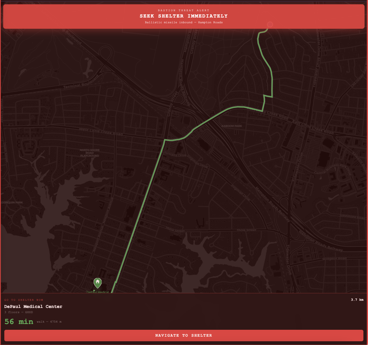
The Civilian Mobile App
What every person carries — no app install, runs in any mobile browser via QR code:
- Gets your real GPS location and instantly finds your nearest hardened shelter
- Shows walking time, distance, floor count, and tier rating
- When alert triggers: phone vibrates, screen flashes red, "SEEK SHELTER IMMEDIATELY" banner
- Mapbox Directions API calculates actual walking route and draws it on the map
- "NAVIGATE TO SHELTER" button opens Google/Apple Maps with walking directions
- Every phone in the audience receives the alert within 2 seconds of the presenter triggering it
Why Parking Garages Are the Best Available Shelter
Since no official shelters exist, we identified multi-level parking garages as the best widely-available protection:
- 7–8 story reinforced concrete provides significant radiation shielding
- Underground levels offer protection factor ~200 (radiation reduced to 1/200th)
- Publicly accessible, numerous, distributed throughout urban areas
- We hand-compiled and rated 10 shelters in Norfolk (Fountain Park Garage: 8 floors, EXCELLENT)
The key insight: You cannot drive out of a blast zone in 30 minutes through panicked traffic. But you CAN walk to a parking garage in 4 minutes and get underground.
How We Built It
- Pure HTML/CSS/JS + Python — zero frameworks, zero build steps, three files
- MapLibre GL JS with CARTO dark basemap for military-aesthetic rendering
- Mapbox satellite tiles + Directions API for shelter routing
- Turf.js for geospatial math — blast radius circles, distance calculations, great-circle arcs
- Real data throughout: actual launch site coordinates, real weapons designations, real recent headlines, NUKEMAP-calibrated blast radii, real restricted airspace zones
- Python ThreadingHTTPServer for real-time alert sync — shared state in memory, 2-second polling
- Shelter database hand-compiled from Norfolk parking structure data
Challenges We Ran Into
- No public shelter database exists — we had to manually identify, geolocate, and rate every viable structure in Norfolk. This is the work FEMA should be doing for every US city.
- Balancing realism with responsibility — showing 307,000 fatalities is heavy, but sanitizing the numbers undermines the point.
- The fundamental challenge: every piece of data we use is publicly available, every API is free, the physics are well-understood. There is no technical barrier. The barrier is entirely institutional — nobody has been tasked with replacing what was dismantled 30 years ago.
What We Learned
- The US is genuinely unprepared for civilian defense in 2026. No shelters, no routing, no databases, no plan.
- Parking garages are surprisingly effective shelters — reinforced concrete + underground levels, everywhere in cities, free to enter.
- 30 minutes is enough to walk to shelter (4–8 min) but NOT enough to drive out of any blast zone at realistic gridlock speeds. The correct action is always shelter-in-place — and nobody is telling people this.
- Open data (FIRMS, USGS, GDELT, NWS) provides remarkable intelligence that could be operationalized into a civilian system today.
- Having every audience member's phone vibrate simultaneously during a simulated launch makes the problem visceral in a way slides never can.
Built With
- css
- gdelt
- html
- javascript
- mapbox-api
- maplibre-gl
- nasa-firms
- nws
- python
- turf.js
- usgs-api


Log in or sign up for Devpost to join the conversation.