-
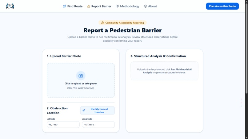
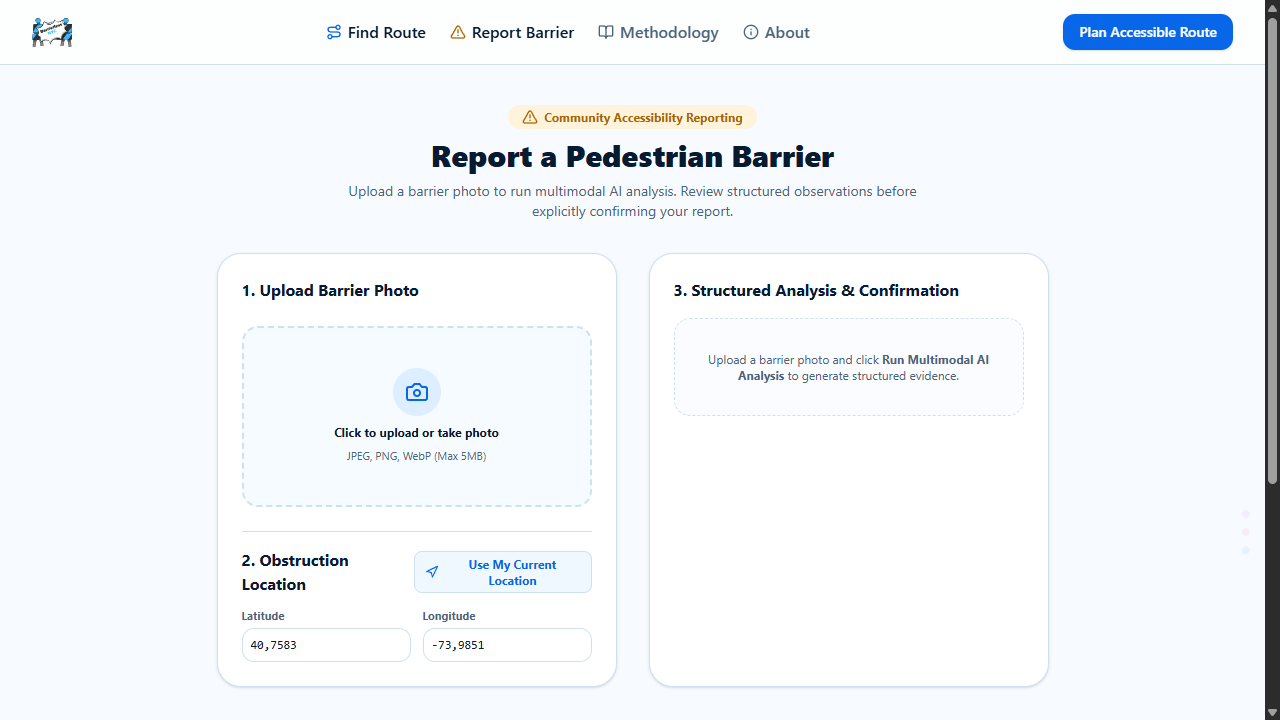
Community members can report temporary accessibility barriers, attach a photo, select the obstruction location, and review AI-assisted.
-
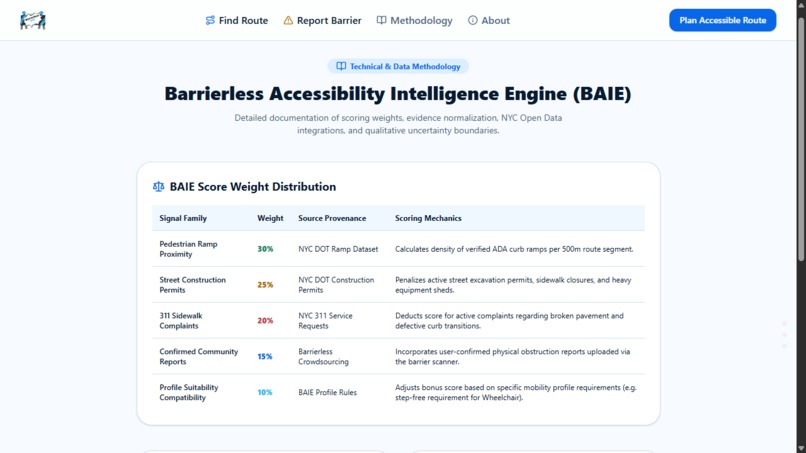
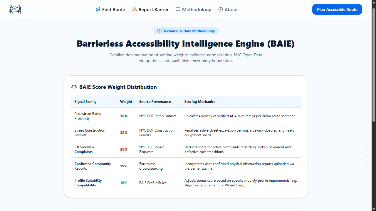
The Barrierless Accessibility Intelligence Engine combines pedestrian ramps, construction permits, 311 complaints, community reports.
-
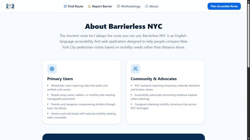
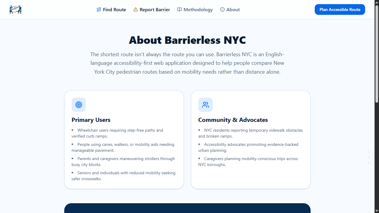
Barrierless NYC is designed for wheelchair users, people with reduced mobility, mobility-aid users, seniors, caregivers, stroller users.
-

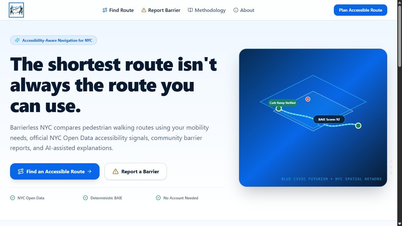
Barrierless NYC introduces accessibility-first pedestrian navigation for New York City, combining mobility needs, NYC Open Data.
-
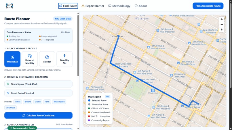
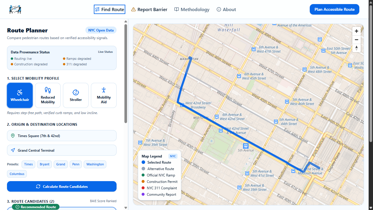
Users can choose a mobility profile, enter their origin and destination, and compare pedestrian routes using accessibility.
-
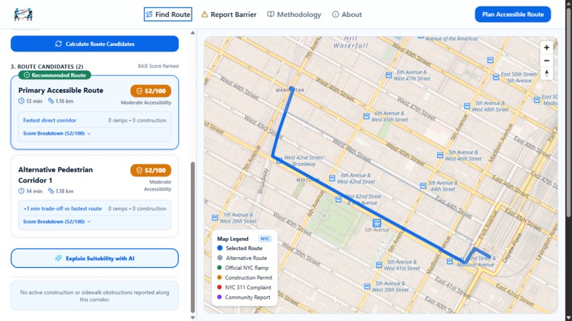
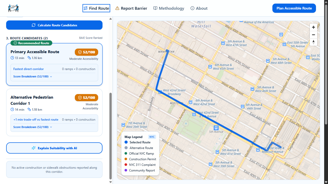
BAIE ranks candidate routes using deterministic accessibility scoring, allowing users to compare travel time, distance, accessibility.
Inspiration
Most navigation apps optimize for one thing: getting from point A to point B as quickly as possible.
But the shortest route is not always a usable route.
For wheelchair users, people with reduced mobility, seniors, people using canes or other mobility aids, and even parents pushing strollers, a seemingly simple walking route can become difficult because of a missing curb ramp, sidewalk construction, an obstruction, or another temporary accessibility barrier.
That led us to one question:
What if navigation optimized not only for distance, but for accessibility?
Barrierless NYC was built around a simple idea:
Google Maps tells you the fastest route. Barrierless NYC helps you understand whether you can actually use it.
What it does
Barrierless NYC is an accessibility-first pedestrian navigation platform for New York City.
Instead of ranking routes only by distance or travel time, Barrierless analyzes accessibility-related signals around each candidate route and generates an explainable accessibility score.
Users can:
- Enter an origin and destination in NYC
- Select a mobility profile
- Compare multiple pedestrian route candidates
- View accessibility-related evidence directly on the map
- See curb ramp, construction, 311, and community-reported barrier signals
- Understand why one route may be more accessible than another
- Upload a photo of a physical barrier for AI-assisted analysis
- Submit community accessibility reports for other users
The goal is not to claim that a route is guaranteed safe or accessible.
Instead, Barrierless provides better evidence for making mobility decisions.
Accessibility Intelligence
At the center of the project is the Barrierless Accessibility Intelligence Engine (BAIE).
BAIE evaluates route candidates using deterministic accessibility signals such as:
- Pedestrian ramp coverage
- Nearby construction conflicts
- Relevant recent 311 reports
- Community-reported barriers
- Route difficulty
These signals are combined into an accessibility score for each route.
We deliberately keep the core ranking logic deterministic and explainable.
Generative AI does not secretly decide which route wins.
Instead, AI is used where it provides the most value: helping users understand already-computed evidence and interpreting potential accessibility barriers from images.
This separation makes the system easier to explain, audit, and improve.
AI Barrier Scanner
Barrierless also includes an AI-assisted Barrier Scanner.
A user can upload a photo of a sidewalk accessibility problem, such as:
- A blocked curb ramp
- Sidewalk obstruction
- Construction interference
- Damaged pedestrian access
- Other mobility barriers
AI analyzes the image and returns structured observations including the possible barrier type, severity, affected mobility profiles, and uncertainty.
The AI output is never automatically published as fact.
The user must review and confirm the result before submitting the report.
If AI analysis is unavailable, Barrierless does not fabricate a result. The user can continue through the manual reporting workflow.
Explainable AI
Barrierless also uses AI to translate structured route evidence into understandable explanations.
Instead of simply displaying:
Accessibility Score: 82
we want users to understand why one route received a higher score.
For example, a route may have stronger curb-ramp coverage while avoiding a nearby construction conflict reported by city data.
The AI explanation is grounded in evidence that has already been collected and scored by BAIE.
When generative AI is unavailable, the platform falls back to a deterministic evidence summary rather than inventing information.
NYC Open Data
New York City already publishes an enormous amount of public information.
Barrierless turns some of that information into mobility context.
The project integrates accessibility-related signals from NYC Open Data, including information related to:
- Pedestrian ramps
- Street construction
- 311 service requests
These signals are spatially compared against candidate pedestrian routes.
Rather than simply placing city datasets on a dashboard, Barrierless asks:
How does this public data affect someone's actual journey through the city?
That is the core civic-tech idea behind the project.
Community Reporting
Official datasets cannot capture every temporary accessibility problem.
A delivery vehicle may block a curb ramp.
Construction equipment may temporarily obstruct a sidewalk.
A pathway may become difficult before it appears in a government dataset.
Barrierless therefore combines official information with community reporting.
Community reports can progress through a simple lifecycle:
Reported → Community Confirmed → Resolved / Expired
Temporary reports should not remain permanent truth, so reports can expire unless they continue to be confirmed.
Our long-term vision is to combine authoritative city data with real-world accessibility observations from the people actually navigating NYC.
Mobility Profiles
Different users have different accessibility requirements.
Barrierless therefore supports mobility profiles such as:
- Wheelchair
- Reduced Mobility
- Mobility Aid
- Stroller
The long-term goal is to make route scoring increasingly sensitive to the needs of each mobility profile instead of assuming that every pedestrian experiences the same city.
How we built it
Barrierless NYC is built as a lightweight web application designed for fast iteration during the hackathon.
Our stack includes:
- Next.js
- React
- TypeScript
- Tailwind CSS
- MapLibre GL JS
- OpenFreeMap
- openrouteservice
- Turf.js
- NYC Open Data / Socrata APIs
- Google Gemini
- Supabase
- Vercel
MapLibre provides the interactive mapping experience while openrouteservice generates pedestrian route candidates.
Turf.js is used for geospatial operations, allowing accessibility evidence to be compared against the geometry of candidate routes rather than relying only on simple coordinate matching.
NYC Open Data provides civic signals.
Supabase stores community-generated accessibility reports.
Google Gemini powers AI-assisted barrier interpretation and evidence-based route explanations.
Challenges we ran into
One of the hardest problems was avoiding a misleading prototype.
It would have been easy to create several visually different routes, assign arbitrary accessibility scores, and present them as intelligent recommendations.
We wanted the system to be more defensible than that.
A major challenge was separating:
- What the data actually tells us
- What the scoring engine calculates
- What AI is allowed to explain
We therefore designed the architecture so that generative AI does not directly control route ranking.
Another challenge was combining datasets with completely different structures and spatial contexts.
A construction permit, pedestrian ramp, 311 complaint, and community report are very different pieces of information, but they all need to become understandable evidence relative to a route.
We also had to design graceful degradation.
External services can fail.
Instead of silently presenting fabricated data as live civic information, Barrierless is designed to distinguish unavailable data, fallback summaries, and demo behavior from real evidence.
Accomplishments that we're proud of
We are especially proud that Barrierless is more than a static accessibility map.
The application connects several systems into one navigation experience:
routing → geospatial analysis → civic data → accessibility scoring → explainable AI → community reporting
We are also proud of keeping the accessibility recommendation system explainable.
A user can inspect the evidence contributing to a recommendation rather than trusting an unexplained AI-generated answer.
Finally, we designed the product around a principle that became increasingly important while building it:
Accessibility information should communicate uncertainty, not hide it.
Barrierless never promises that a recommended route is guaranteed to be safe or accessible.
Instead, it gives people better information for making that decision themselves.
What we learned
Building Barrierless changed how we thought about navigation.
Accessibility is not simply another checkbox that can be added to an existing map.
It is highly contextual.
A route that works today may become difficult tomorrow because of construction.
A route that works for someone pushing a stroller may not work for someone using a wheelchair.
We also learned that generative AI can be much more useful when it is placed inside a constrained system.
Instead of asking an LLM to magically determine the best route, we use deterministic geospatial calculations to rank routes and use AI primarily to interpret and communicate evidence.
That makes the technology more trustworthy and useful.
What's next for Barrierless NYC
This hackathon version is an MVP, but the idea can grow much further.
Future improvements could include:
- More NYC accessibility datasets
- Elevator and transit accessibility information
- Better sidewalk quality data
- Personalized accessibility weighting
- Route-specific elevation and slope analysis
- Stronger community verification
- Temporary barrier expiration and reconfirmation
- Borough-scale accessibility heatmaps
- Better accessible entrance information
- Historical accessibility reliability
- More mobility profiles
- Accessibility-aware multimodal transit routing
A particularly interesting direction would be building an Accessibility Knowledge Layer for NYC.
Instead of accessibility information being scattered across separate government datasets, community reports, transportation systems, and individual observations, Barrierless could provide a shared layer that other civic applications could eventually consume.
Our vision
New York is one city, but people experience its streets differently.
Navigation software should recognize that.
Barrierless NYC imagines a future where accessibility is not an afterthought attached to navigation.
It is part of the routing decision itself.
Navigate New York by accessibility, not just distance.
Built With
- css
- data
- gemini
- generative
- geospatial
- gl
- javascript
- maplibre
- next.js
- nyc
- open
- openfreemap
- openrouteservice
- postgresql
- react
- socrata
- supabase
- tailwind
- turf.js
- typescript
- vercel
- zod

Log in or sign up for Devpost to join the conversation.