Inspiration
Climate data exists. Decisions don't.
Morocco has pledged 52% renewable energy by 2030 — one of the most ambitious targets in Africa. The sun shines. The wind blows. The potential is undeniable. Yet energy planners still spend months assembling feasibility pictures from fragmented reports, outdated documents, and disconnected APIs.
We asked one question: what if the data could speak for itself?
The answer is AtlasClima AI.
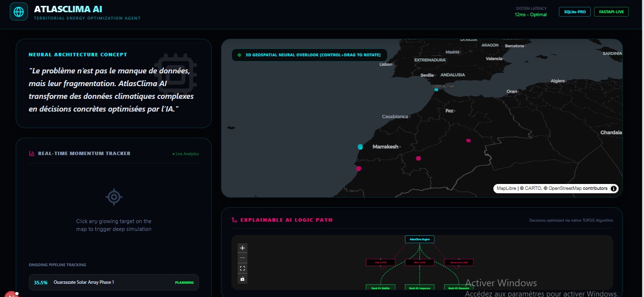
"Le problème n'est pas le manque de données, mais leur fragmentation. AtlasClima AI transforme des données climatiques complexes en décisions concrètes optimisées par l'IA."
What it does
AtlasClima AI is a full-stack climate intelligence platform that crawls real meteorological data, processes it through a scientific multi-criteria decision engine, and outputs ranked renewable energy site recommendations — in real time.
Core features:
Live Data Crawling — Open-Meteo API fetches 30-day rolling climate data (solar radiation, wind speed, temperature, water stress) for 8 Moroccan regions with no API key required.
Solar Modeling — pvlib computes Direct Normal Irradiance (DNI) and clearsky solar potential using professional PV modeling standards.
TOPSIS Decision Engine — scikit-criteria applies the Technique for Order of Preference by Similarity to Ideal Solution across 5 weighted criteria, producing a scientifically grounded ranking of sites.
Simulation Engine — Click any point on the map, get real-time ROI and energy production estimates from a live FastAPI backend.
Interactive 3D Map — deck.gl renders Morocco's renewable potential as an explorable spatial intelligence layer.
XAI Graph — React Flow visualizes the decision pipeline as an explainable node graph, so every output is traceable and transparent.
$$ \text{TOPSIS Score} = \frac{d^-}{d^+ + d^-} $$
Where $d^+$ is the distance from the ideal solution and $d^-$ is the distance from the negative ideal solution, computed across our 5 climate criteria.
How we built it
We built a fully decoupled full-stack architecture with two separate servers communicating via REST API.
Backend (FastAPI + Python)
FastAPI+Uvicornas the REST API serverSQLite(atlasclima.db) for persisting site evaluations and simulation requestsopenmeteo-requestsfor live climate data crawlingpvlibfor professional solar irradiance modelingscikit-criteriafor TOPSIS multi-criteria rankingpandas+numpyfor data transformation
Frontend (Next.js + React)
Next.jswithTailwindCSSfor the dashboarddeck.gl+react-map-glfor the 3D interactive mapReact Flowfor the XAI decision graph- Real-time
POST /api/simulatecalls on map click events
Data pipeline: Open-Meteo API → pvlib DNI Modeling → scikit-criteria TOPSIS → FastAPI REST endpoints → React dashboard
Challenges we ran into
1. Data fragmentation is the real problem Not the lack of data — but the integration. Solar data, wind data, temperature risk, and water stress live in completely different formats and update at different frequencies. Building a unified pipeline that normalizes all of these in real time was the core engineering challenge.
2. Making MCDA explainable TOPSIS produces a score. But a score without explanation is meaningless to a decision-maker. We built the XAI React Flow graph specifically to show why a site ranked where it did — which criteria drove it up, which pulled it down.
3. Equity by design, not by afterthought Most energy optimization tools optimize for output. We had to deliberately encode equity into our weights — giving additional priority to rural regions historically excluded from infrastructure investment. That's a values decision, not just a technical one.
Accomplishments that we're proud of
- A live simulation engine that queries real climate data for any GPS coordinate in Morocco on demand
- A scientifically rigorous MCDA pipeline using published methodology (TOPSIS), not arbitrary weighted formulas
- An explainable AI graph that makes every decision transparent and traceable
- An equity lens baked into the weighting system — not added as a footnote
What we learned
Fragmentation, not data scarcity, is the bottleneck in climate infrastructure planning.
We also learned that technical rigor and storytelling are not opposites. A TOPSIS score means nothing without context. A beautiful map means nothing without defensible methodology. AtlasClima AI needed both.
Finally: the Global South doesn't lack renewable potential. It lacks integrated decision tools built for its context, not adapted from tools built for Europe.
What's next for AtlasClima AI
- Scale to all 54 African nations — same pipeline, continental coverage
- Integrate economic data — land cost, grid access distance, population density
- Partner with NGOs and local governments for real implementation pilots
- Multi-stakeholder weight customization — let communities define their own priority criteria, not just engineers


Log in or sign up for Devpost to join the conversation.