-
-
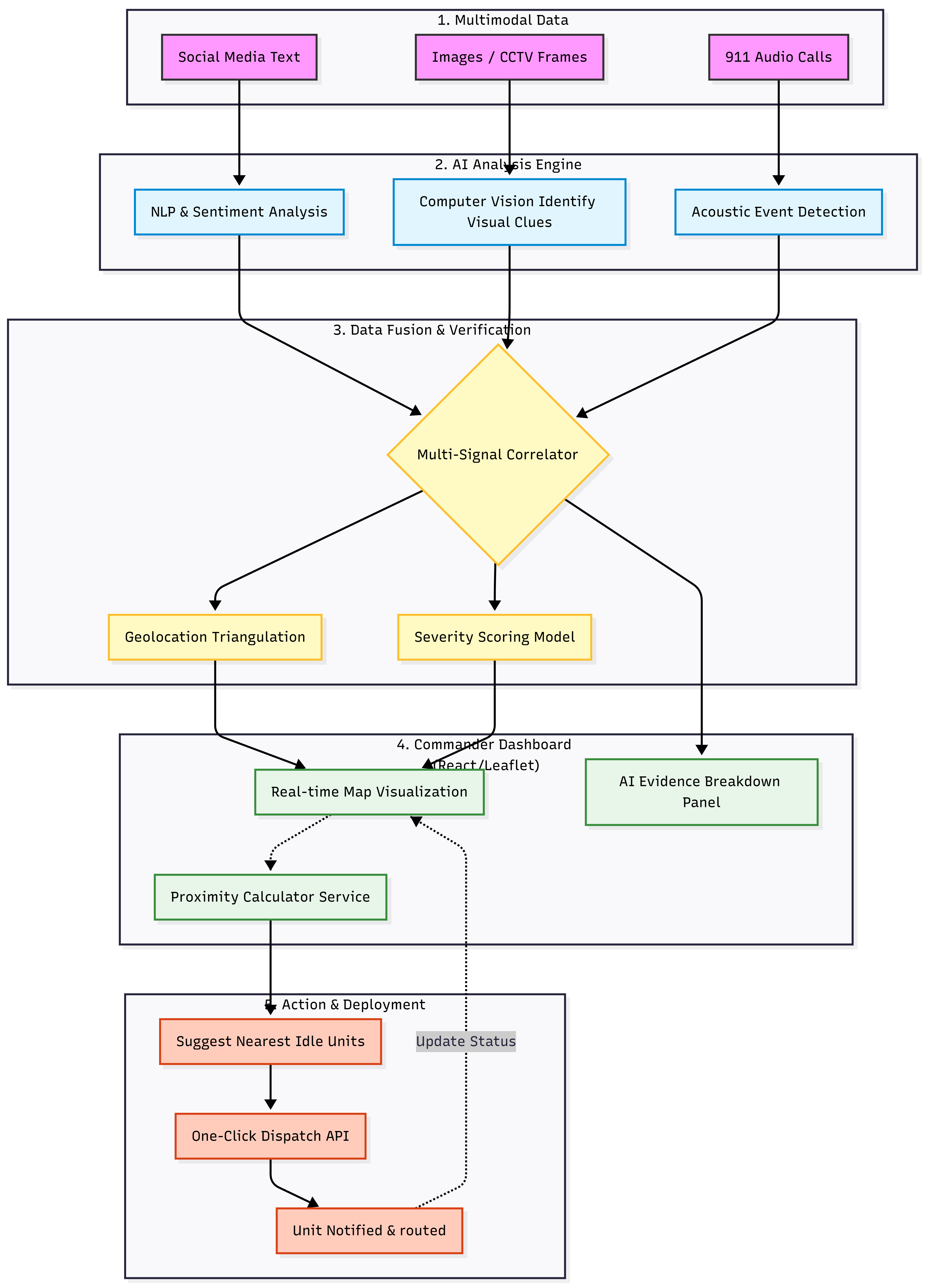
Architecture
Argus.AI: Panoptic Surveillance & Intelligent Crisis Response
💡 Inspiration
We hear tragic news every other day—lives are lost or suffering is prolonged simply because emergency services could not reach the scene in time. The gap between an incident occurring and authorities being notified is often too wide. While official channels can be slow, social media is instant. People post images, videos, and updates about disasters, accidents, or fires within seconds.
Argus.AI was born from the idea of harnessing this real-time flood of multimodal public signals to reduce response time and ensure that help reaches the right place at the right moment.
🚀 What it does
Argus.AI is an intelligent emergency response command center designed for real-time public safety monitoring.
- Multimodal Intelligence: Ingests unstructured public data streams such as text, images, and voice inputs originating from social platforms and emergency helplines.
- Privacy-First, Ephemeral Media Handling: All user-submitted media is treated as transient inference input. Images and audio are processed in-memory and forwarded to the AI engine in encoded form, without persistent storage. Only structured intelligence outputs—such as hazard type, severity score, and inferred location—are retained.
- Smart Dispatch: Automatically identifies and notifies the nearest available Police, Fire, or Medical unit using real-time geospatial routing logic.
⚙️ How we built it
The architecture is designed with speed, privacy, and operational scalability as first-class concerns.
Client-Side Preprocessing & Serialization To enforce privacy-by-design and reduce backend load, media is preprocessed on the client side (compression and format normalization) and serialized into an encoded representation before transmission. Raw media files are never persisted on the server.
AI Analysis (Multimodal General-Purpose Model) The serialized multimodal payload is sent for synchronous inference to a capable multimodal generalized AI model. The model analyzes visual, textual, and acoustic cues (e.g., smoke plumes, fire patterns, distress signals) and returns a structured JSON-based risk assessment.
Real-Time Command Dashboard A live command interface built with React and Leaflet Maps updates instantly via Socket.io, enabling operators to visualize incidents as they emerge.
Geospatial Routing Logic To ensure precision dispatch, we implemented the Haversine Formula directly within the system to calculate the great-circle distance between reported incidents and available response units.
Distance Calculation Formula
To account for the Earth’s curvature, distance is computed as:
$$a = \sin^2\left(\frac{\Delta\phi}{2}\right) + \cos(\phi_1) \cdot \cos(\phi_2) \cdot \sin^2\left(\frac{\Delta\lambda}{2}\right)$$ $$c = 2 \cdot \text{atan2}\left(\sqrt{a}, \sqrt{1-a}\right)$$ $$d = R \cdot c$$
Where $\phi$ is latitude, $\lambda$ is longitude, and $R$ is the Earth’s radius (6,371 km).
🚧 Challenges we ran into
Media handling under strict latency and privacy constraints was the primary challenge.
- The Problem: Introducing intermediate storage layers—such as uploading media to cloud buckets before analysis—adds latency and increases privacy risk, which is unacceptable in emergency response scenarios.
- The Solution: We designed a zero-persistence inference pipeline where media is processed ephemerally and passed directly to the AI engine for real-time analysis. By eliminating unnecessary storage hops and disk I/O, the system minimizes time-to-insight while ensuring that only actionable intelligence—not raw media—is retained.
🏆 Accomplishments that we're proud of
- Privacy by Design: Built a surveillance and response pipeline that extracts intelligence without hoarding sensitive user media.
- Unified Multimodal Intelligence: Seamlessly merged voice calls and social media imagery into a single operational view.
- Precision Dispatch: Ensured that the closest emergency unit is always identified using accurate geospatial computation.
🧠 What we learned
- Handling Transient Multimodal Payloads: Gained experience processing large encoded media payloads safely in-memory while preventing Node.js event loop congestion and ensuring immediate disposal after inference.
- Geospatial Engineering: Developed a strong understanding of spherical distance computation and its importance in real-world routing decisions.
🔮 What's next for Argus.AI
We envision Argus.AI evolving into a city-scale operating system for emergency response:
- Queue-Based Scalability: Introduce Redis-backed queues and worker pools to handle traffic spikes during large-scale disasters.
- CCTV Crowd Analysis: Integrate institutional video feeds with a policy-driven storage model, where only high-risk or operator-verified frames are retained for audit and post-incident analysis.
- Dynamic Evacuation Routing: Generate safe evacuation paths by incorporating hazard proximity into routing costs: $$Cost(path) = \sum_{i=0}^{n} (distance_i \times risk_factor_i)$$
- Automated Compliance Reporting: Aggregate structured incident logs to automatically generate audit-ready reports for government and emergency authorities.
Built With
- and-leaflet)-and-an-express-backend
- gemini
- google-cloud
- node.js
- powered-by-mongodb-for-storage
- react.js
- socket.io
- socket.io-for-real-time-updates
- tailwind-css
- typescript


Log in or sign up for Devpost to join the conversation.