Inspiration
Water scarcity, rising utility costs, and increasing climate pressure are forcing commercial property owners to think differently about water. The problem is not that rainwater reuse lacks value — it is that identifying the right buildings is still fragmented, manual, and slow.
We built AquaScan around a simple idea: what if every rooftop could be evaluated like a water asset? Instead of leaving rainwater harvesting to guesswork, spreadsheets, or one-off site studies, we wanted to create a system that automatically finds high-potential buildings, quantifies the opportunity, and explains why the opportunity matters right now.
AquaScan turns sustainability from a vague ambition into a clear, ranked, financially legible decision.
What it does
AquaScan is an AI-powered commercial rainwater intelligence platform that identifies buildings with strong rainwater harvesting potential, calculates viability, and generates decision-ready outputs in seconds.
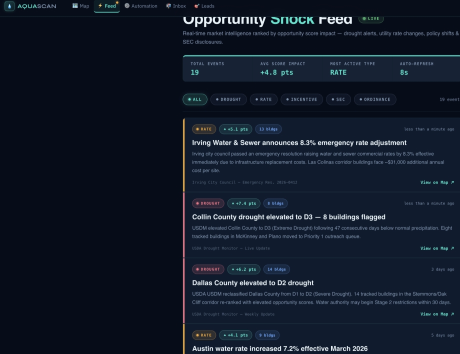
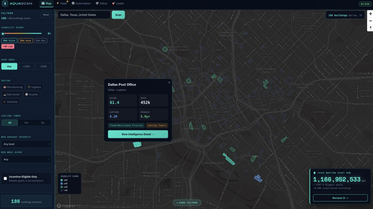
The platform scans commercial buildings, analyzes rooftop geometry and imagery, estimates annual rainwater capture, computes financial upside, and ranks buildings using a composite viability model. From there, it turns those findings into actionable outputs like building-level insights, ROI summaries, and AI-generated deal memos.
In practice, AquaScan helps users answer:
- Which buildings are worth targeting first?
- How much rainwater could they capture?
- What is the expected financial return?
- Why is this building strategically valuable now?
How we built it
We built AquaScan as a full-stack geospatial intelligence system.
On the frontend, we used Next.js, React, Tailwind CSS, and Mapbox GL to create an interactive map-based interface that makes it easy to explore and compare commercial building opportunities.
On the backend, we used FastAPI and Python to handle building footprint retrieval, satellite-image analysis, hydrology calculations, scoring, and financial modeling.
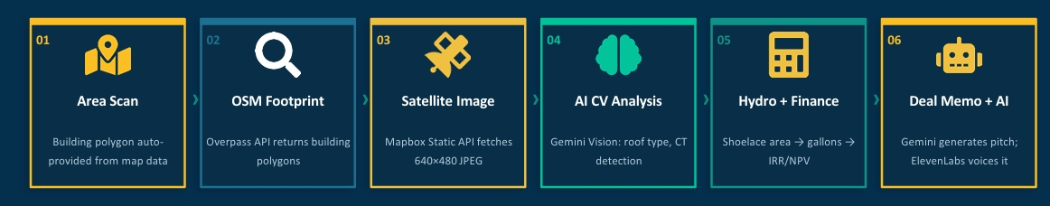
The pipeline works like this:
- Pull building footprint geometry from map data
- Fetch satellite imagery for the site
- Use AI vision to analyze rooftop features and cooling-tower signals
- Compute roof area, annual water capture, and economic return
- Rank buildings using our viability models
- Generate AI-powered business collateral like deal memos and pitch summaries
We also integrated external services and datasets across geospatial imagery, building geometry, AI vision, and reporting workflows to make the system feel like a real intelligence engine rather than a static dashboard.
Novelty
What makes AquaScan different is that it is not just a map, not just a model, and not just an AI wrapper.
Our novelty comes from the way we combine satellite analysis, building geometry, hydrology, financial modeling, and AI-generated business intelligence into one continuous workflow.
AquaScan stands out in four major ways:
Satellite + AI vision at scale
We combine building footprint geometry, satellite imagery, and computer vision to automatically assess rooftop potential across commercial districts.Full financial stack in one pass
We do not stop at detection. We go from coordinates to roof area to gallons captured to payback, IRR, and NPV in one pipeline.Proprietary scoring models
AquaScan uses both a Viability Score and a Water Resilience Alpha Index (WRAI) to rank buildings across physical, economic, and strategic dimensions.AI-generated action layer
Instead of only showing analytics, AquaScan generates deal memos, pitch framing, and business-facing outputs that make the analysis usable immediately.
That combination makes the platform feel less like an analytics dashboard and more like a commercial decision engine.
Mathematical models
AquaScan is powered by a quantitative engine that translates raw building data into real physical and financial opportunity.
Formula 1: Roof Area Model
We compute rooftop area using the Shoelace Formula (Gauss’s Area Formula) on building polygon coordinates.
Area (m²) = |Σ(x_i * y_{i+1} - x_{i+1} * y_i)| / 2
Where coordinate conversion is handled as:
lat_to_meters = 111,320 m/degreelng_to_meters = 111,320 * cos(center_latitude) m/degree
Then we convert metric area into square feet:
Area (sqft) = Area (m²) × 10.7639
Implementation reference:
compute_polygon_area_sqm() [building_footprint_service.py]
Formula 2: Annual Rainwater Capture
We estimate annual rainwater capture using:
G = A × R × 0.623 × η
Where:
- A = Roof area (sqft) — from Shoelace above
- R = Annual rainfall (inches) — NOAA state lookup
- 0.623 = 1 inch rain on 1 sqft = 0.623 gallons
- η = Runoff coefficient (0.78–0.92, varies per building)
This model lets AquaScan convert rooftop geometry into estimated annual water capture, which then feeds into ROI, payback, IRR, and overall viability scoring.
Architecture
AquaScan follows a layered architecture designed for explainability and speed.
External Data Layer
This includes building footprint sources, satellite imagery, AI vision services, and public intelligence signals.
Backend Intelligence Layer
Our Python/FastAPI backend handles:
- footprint extraction
- CV analysis
- hydrology
- financial modeling
- scoring
- report generation
Frontend Experience Layer
The frontend provides:
- interactive map exploration
- building overlays
- live scoring views
- simulation feedback
- memo and pitch generation
The architecture is intentionally modular so each layer can evolve independently — better imagery, stronger finance models, or richer reporting can all plug into the same system without rebuilding the product from scratch.
Key Design Principles
We built AquaScan around a few clear design principles:
1. Explainability first
If a building is ranked highly, the user should understand why. We designed the system so recommendations feel grounded, not mysterious.
2. Action over analysis
A lot of sustainability software stops at insight. We wanted AquaScan to move from insight to action by generating outputs people can actually use in outreach, evaluation, or investment discussion.
3. Enterprise-style usability
We wanted the platform to feel credible for serious users. That meant clean map interactions, strong information hierarchy, and a workflow that feels more like a real operating tool than a hackathon demo.
4. Quantitative credibility
We made sure the product was backed by real formulas, interpretable scoring, and financial logic — not just AI-generated text.
Why us
We did not build AquaScan as a generic dashboard. We built it as a decision system.
Most tools either visualize geospatial data, run isolated sustainability calculations, or generate AI summaries with no operational grounding. AquaScan is different because it combines all three into one workflow: physical site detection, quantitative opportunity modeling, and AI-generated business outputs.
Our advantage is that we are not just showing where rainwater exists — we are showing where it is worth acting on. That means users do not just get data; they get prioritization, justification, and a path to action.
Challenges we ran into
One of our biggest challenges was balancing AI flexibility with decision reliability.
It is easy to build something flashy with AI. It is much harder to build something that users could actually trust when money, infrastructure, and implementation decisions are involved.
Some of the specific challenges we faced were:
- integrating AI analysis into a pipeline that still feels explainable
- turning messy geospatial data into structured building intelligence
- connecting physical rooftop potential to financial value cleanly
- building an end-to-end product under hackathon time pressure
- making the interface feel polished while still handling real quantitative outputs
Accomplishments that we're proud of
We are proud that AquaScan feels like more than a prototype.
We built a system that connects the full chain:
site discovery → building analysis → water capture modeling → ROI calculation → ranked prioritization → AI-generated business output
We are especially proud of:
- building a real map-based intelligence workflow
- integrating quantitative models with AI outputs
- creating proprietary scoring layers instead of generic ranking
- making the product look and feel enterprise-ready
- turning a sustainability problem into a commercially actionable platform
What we learned
This project taught us that good AI products are not just about generating outputs — they are about generating trust.
We learned that:
- AI is strongest when paired with structured models and domain logic
- quantitative transparency matters
- good UX is about reducing decision friction
- the most compelling products are the ones that go from insight to action, not just insight to interface
Business Impact
AquaScan has strong business value because it reframes rainwater harvesting as a commercial opportunity discovery problem.
Instead of requiring teams to manually evaluate buildings one at a time, AquaScan creates a scalable system for identifying, ranking, and justifying the best targets. That means:
- faster prospecting
- better infrastructure targeting
- clearer ROI communication
- stronger sustainability sales enablement
The result is a platform that could be valuable for water infrastructure companies, sustainability teams, real estate portfolios, utilities, and climate-focused investors.
Built With
- Frontend: Next.js, React, Tailwind CSS, Mapbox GL
- Backend: FastAPI, Python
- AI: Gemini APIs / computer vision workflows
- Data: Building geometry, satellite imagery, environmental and financial inputs
- Visualization: Interactive geospatial dashboard and custom scoring views
What’s next for AquaScan
We want to push AquaScan from a powerful prototype into a production-grade water opportunity platform.
Next steps include:
- integrating more live satellite and aerial imagery sources
- improving building-level obstruction and rooftop quality detection
- expanding municipal incentive and pricing datasets
- adding deeper portfolio-level analysis for enterprise users
- making the scoring engine more adaptive across regions and building types
- turning the platform into a repeatable SaaS workflow for sustainability and infrastructure teams
Why AquaScan
AquaScan is not just another sustainability dashboard.
It is a decision engine for commercial water opportunity discovery — one that combines geospatial intelligence, quantitative modeling, and AI-generated business context into a single workflow.
It helps users find the right rooftops, understand the numbers, and move toward action faster.
Built With
- elevenlabs
- gemini
- logic-engine
- next.js
- python
- react.js
- tailwindcss
- typescript


Log in or sign up for Devpost to join the conversation.