-
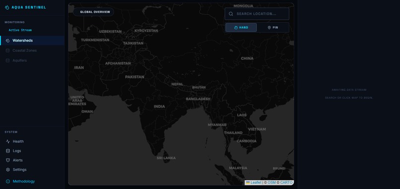
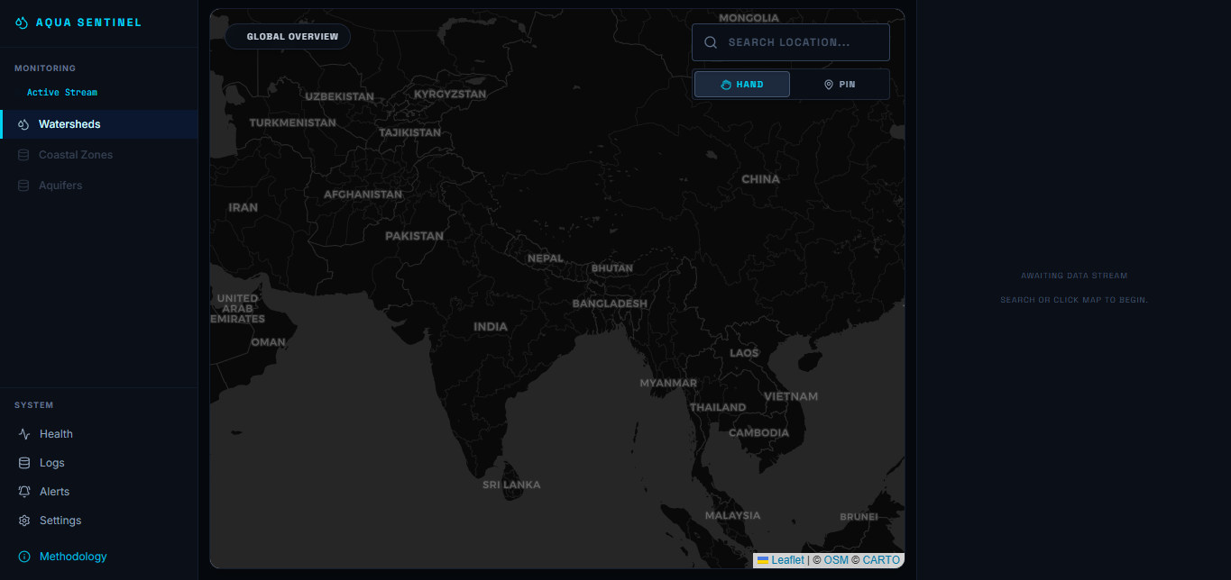
Provides a global map overview for exploring locations, searching areas, and selecting a point to initiate environmental risk analysis.
-
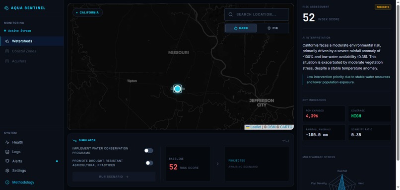
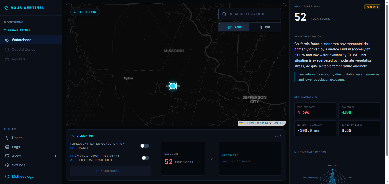
Presents California’s baseline environmental risk, AI analysis, key indicators, and configurable conservation intervention before simulation
-
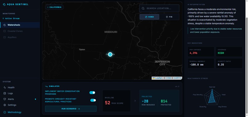
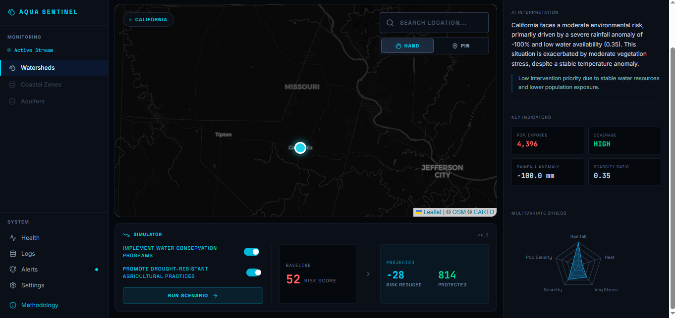
Shows risk assessment with environmental indicators and a completed intervention simulation projecting reduced risk and protected population
-
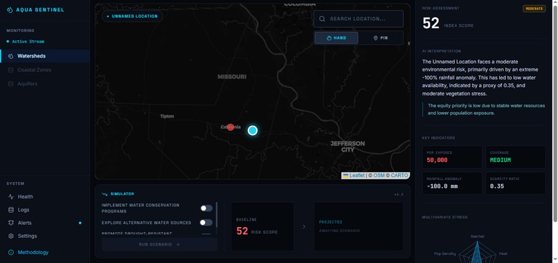
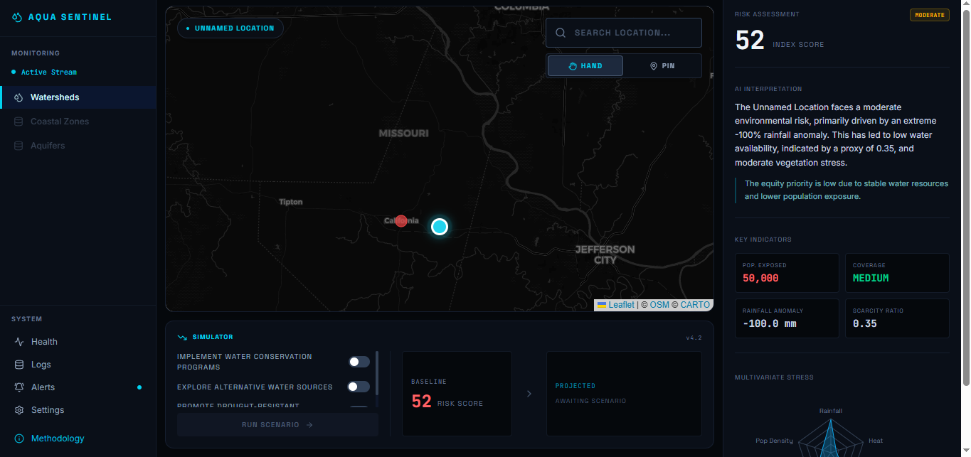
Calculates environmental risk for a user-selected location by dropping a pin, fetching location data and generating real-time risk assesment
Inspiration
Water scarcity is rarely just a problem of how much rain falls. It is a combination of climate stress, environmental conditions, population exposure, and the ability of communities to respond.
We wanted to build something that could answer a simple but important question:
"If I point at any place on Earth, can I understand its environmental water stress, who is exposed, and what could be done about it?"
That led to Aqua Sentinel — an AI-powered environmental intelligence platform designed to turn complex environmental data into understandable, actionable decisions.
Instead of showing a static collection of sustainability statistics, we wanted Aqua Sentinel to work dynamically: search for a location or drop a pin anywhere on the map, analyze the available environmental data, understand the major stress factors, prioritize areas based on population exposure, and simulate potential interventions.
What it does
Aqua Sentinel transforms a geographic location into an explainable environmental risk profile.
Users can:
- Search for any location using the global location search.
- Drop a pin anywhere on the map to analyze a specific coordinate, including locations that are not cities.
- Retrieve environmental and climate indicators from public data sources.
- Calculate a transparent Water/Climate Stress Score using a deterministic risk engine.
- Understand the major factors contributing to the score.
- Estimate population exposure and intervention priority.
- Use Gemini AI to explain the environmental situation in human-readable language.
- Receive context-aware intervention recommendations.
- Run an Intervention Simulator to compare a baseline scenario with a projected intervention scenario.
- Inspect the methodology and data sources behind the analysis.
The goal is not to claim that Aqua Sentinel replaces professional hydrological modelling. Instead, it acts as an environmental decision-support prototype that makes complex climate and water-related information easier to explore and reason about.
How we built it
Aqua Sentinel combines geospatial interaction, environmental data, deterministic modelling, AI, and scenario simulation.
Location Intelligence
The application supports two ways of selecting a location:
Search → Select → Analyze
or
Pin Mode → Click Anywhere → Analyze
This means the system is not restricted to a predefined list of cities.
Coordinates are treated as the canonical location identity, allowing the platform to analyze both urban and rural locations.
Environmental Data
We use public environmental data sources such as:
- Open-Meteo for weather and climate indicators.
- NASA POWER for historical meteorological and climate information.
The application retrieves data on demand rather than loading environmental information for the entire planet.
Risk Engine
Environmental indicators are normalized and passed through a deterministic risk engine.
The model considers factors such as:
- precipitation stress
- temperature/heat stress
- evaporative demand
- soil-moisture indicators where available
- population exposure
These are combined into a transparent 0–100 environmental water/climate stress score.
The numerical score is deliberately calculated by our own deterministic model rather than by an LLM, making the result reproducible and explainable.
Equity Layer
Environmental severity alone does not tell us where intervention should happen first.
Aqua Sentinel therefore adds a population-exposure perspective to identify locations where environmental stress overlaps with a larger exposed population.
This produces an Equity Priority indicator rather than claiming to directly measure socioeconomic vulnerability.
AI Intelligence
Gemini is used as an interpretation layer.
The AI receives structured environmental and risk information produced by our system and explains:
- what is driving the stress
- why the location is important
- what interventions may be appropriate
- what uncertainties or limitations exist
The AI does not invent environmental measurements or determine the official numerical risk score.
Intervention Simulator
The final layer turns analysis into action.
Users can select interventions such as:
- rainwater harvesting
- groundwater recharge
- demand reduction
- urban catchment improvements
The simulator compares the baseline with a projected scenario based on our intervention assumptions.
This lets users move from:
"What is happening?"
to:
"What could we do about it?"
Performance and Caching
Environmental APIs are not called continuously.
A cache-first architecture using Supabase stores location, environmental, and analysis results.
The system uses:
- debounced location search
- on-demand analysis
- persistent caching
- request deduplication
- progressive loading
- server-side API calls
- no environmental API calls while simply panning or zooming the map
This allows us to explore many locations while remaining practical for free-tier infrastructure.
Challenges we ran into
One of our biggest challenges was avoiding the temptation to build a visually impressive dashboard filled with numbers that were not actually supported by data.
Our initial prototype relied heavily on simulated locations and values. As the project evolved, we realized that this would undermine the credibility of the system.
We therefore redesigned the architecture around real data provenance.
Another challenge was scale.
Loading environmental information for every location on Earth would be unnecessarily expensive and slow. Instead, we designed Aqua Sentinel around an on-demand intelligence model:
The planet is the interface, but we only analyze the part the user asks about.
We also had to solve the interaction problem of allowing users to select arbitrary coordinates. This led to the dual Hand Mode / Pin Mode map interaction, allowing users to freely explore the map and then explicitly select a location for analysis.
Finally, integrating AI without allowing the model to hallucinate scientific measurements required a clear separation between the deterministic data/risk pipeline and the Gemini interpretation layer.
Accomplishments that we're proud of
We are particularly proud of turning Aqua Sentinel from a static environmental dashboard into a generalized location intelligence system.
Some of the features we are most proud of are:
- 🌍 Analyze almost any location rather than relying on a fixed city database.
- 📍 Drop a pin anywhere on the map and analyze that coordinate.
- 🔎 Search locations globally.
- 📊 Generate a transparent environmental stress score.
- 👥 Incorporate population exposure into intervention prioritization.
- 🤖 Use Gemini for explainable environmental intelligence rather than letting an LLM fabricate the underlying measurements.
- 💧 Simulate potential interventions and compare projected outcomes.
- ⚡ Use caching and on-demand processing to reduce unnecessary API usage.
- 🔬 Maintain data provenance and distinguish real, historical, derived, estimated, and simulated information.
- 🎛️ Build the experience as an operational environmental intelligence dashboard rather than a conventional sustainability website.
Most importantly, we are proud that the system is designed around a principle of "no fake data": when the required data is unavailable, the system should say so rather than invent a value.
What we learned
We learned that building an AI-powered environmental application is not simply about connecting an LLM to an API.
The most important part is the architecture surrounding the AI.
We learned to separate:
Data → Normalization → Deterministic Analysis → AI Interpretation → Action
rather than asking an LLM to perform the entire process.
We also learned the importance of data provenance. A number on a dashboard is only useful when the user can understand where it came from and whether it is measured, historical, derived, estimated, or simulated.
From the engineering side, we learned how important caching, request deduplication, progressive loading, and careful API usage become when building a data-intensive application under free-tier constraints.
Most importantly, we learned that environmental intelligence becomes much more useful when it connects risk to action.
What's next for Aqua Sentinel
Aqua Sentinel is currently a prototype, but the architecture is designed to grow into a much richer environmental intelligence platform.
Future work includes:
- integrating satellite-derived vegetation indicators such as NDVI
- incorporating more detailed population and vulnerability datasets
- adding watershed and aquifer boundaries
- incorporating groundwater and water-resource datasets
- improving regional climate baselines
- adding richer spatial analysis
- improving intervention impact modelling
- adding multi-location comparison and prioritization
- supporting organizations in identifying where limited resources could have the greatest impact
- developing more rigorous uncertainty and validation methodologies
Our long-term vision is to make Aqua Sentinel a tool where a decision-maker can point anywhere on the planet, understand the environmental pressure there, identify who is exposed, and explore what interventions could make the greatest difference.
The vision
Aqua Sentinel is built around a simple idea:
Don't just tell people that water stress exists. Show them where it is, explain why it is happening, identify who is exposed, and help them explore what can be done.
Built With
- api
- css
- gemini
- geospatial
- gis
- leaflet.js
- nasa
- next.js
- open-meteo
- postgresql
- power
- react
- rest
- supabase
- tailwind
- typescript

Log in or sign up for Devpost to join the conversation.