🎯 Track Alignment Selected Track: Track 4 — Climate Data & Environmental Monitoring Interconnected Impact: Track 1 (Transparency & Auditing) & Track 3 (Sustainable Agriculture & Supply Chains)
AMARU directly addresses the core mandate of the Climate Data & Environmental Monitoring track by transforming fragmented, raw satellite earth observations (NASA FIRMS, NOAA, Copernicus Sentinel, Open-Meteo) into cryptographically certified, actionable Early Action intelligence. By binding real-time geospatial fire and hydrometeorological telemetry to Polygon blockchain Merkle notarizations, AMARU eliminates data manipulation risks, detects remote thermal anomalies beyond traditional administrative field registries, and provides tamper-proof parametric evidence for anticipatory climate relief.
Inspiration Global ocean heat content across the Tropical Pacific has reached unprecedented thermodynamic saturation. Authoritative climatological forecasts warn that the 2026–2027 El Niño / Southern Oscillation (ENSO) cycle is trending toward a high-magnitude "Mega-Niño" event, triggering cascading compound catastrophes: catastrophic coastal flash floods, severe Andean freeze surges (< -15°C), and thermal-chimney wildfires spreading uphill at 4 km/h.
While multilateral agencies (NOAA, ECMWF) generate petabytes of satellite telemetry, early warnings catastrophically fail at the operational "Last Mile" (from Central State authorities to frontline citizens) due to administrative latency and dense technical jargon. In Peru alone, billions are budgeted annually for disaster risk reduction (e.g., Programa Presupuestal PP 0068 with over S/ 4.12 Billion), yet emergency response is consistently paralyzed by what we call the "Tragedy of the Golden Window":
Local mayors and civil defense authorities face criminal prosecution under administrative abuse laws if they disburse disaster funds without exhaustive bureaucratic justification. While recent national initiatives like mobile digital censuses modernize post-impact reporting, physical ground assessments are fundamentally reactive and cannot operate during the critical pre-impact window. Hydraulic concentration times for flash floods (huaicos) are between 4 and 12 hours, and wildfires propagate uphill rapidly through chimney effects. In remote mountainous terrain where ground evaluators cannot travel in time, municipalities become administratively blind. Terrified of wrongful liability and post-disaster audits, honest officials freeze during the Golden Window. Worse, when emergency funds are hastily unlocked under non-competitive tenders, the absence of auditable telemetry opens the door to price gouging, phantom machinery rentals, and corruption.
We were inspired by the imperative of institutional trust in public engineering: technology must protect honest civil servants from wrongful liability, break bureaucratic paralysis during critical early-warning windows, and eliminate corruption without slowing down life-saving humanitarian relief.
What it does AMARU is an enterprise-grade Command and Control (C2), Early Action, and Climate Audit platform that combines autonomous AI multi-agent orchestration with a Triple-Layer Cryptographic Blockchain Notary:
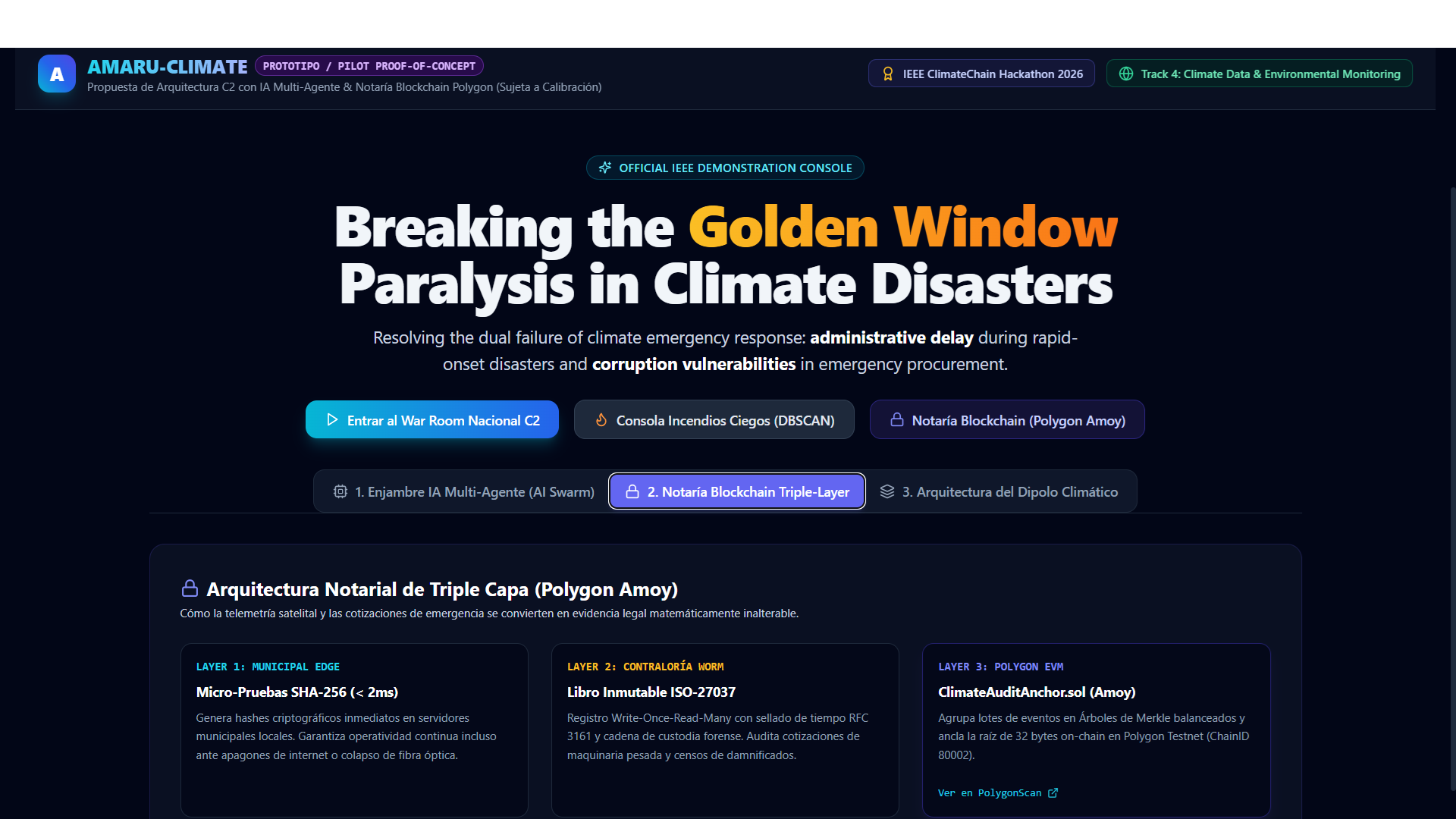
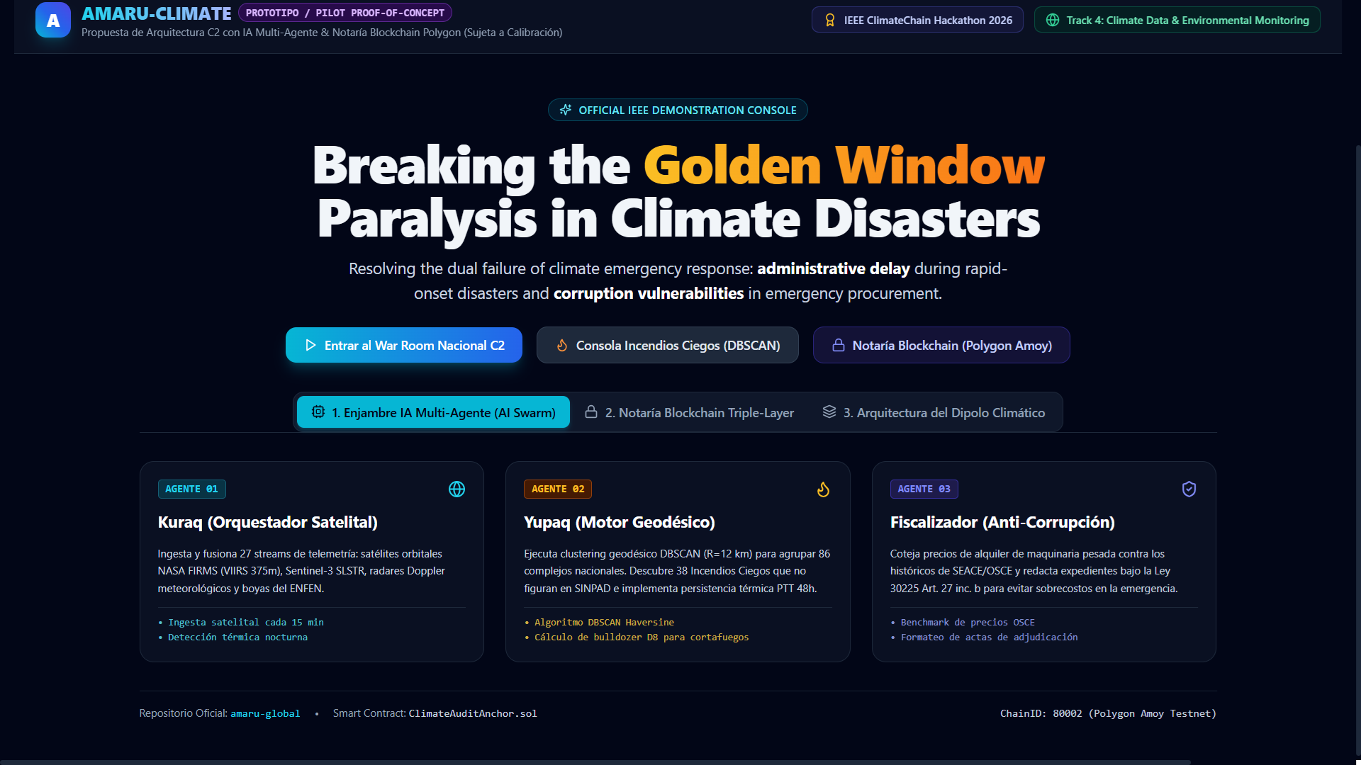
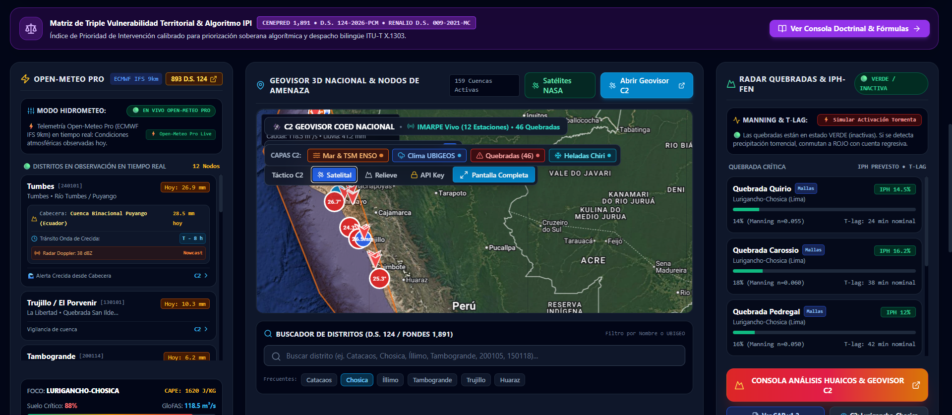
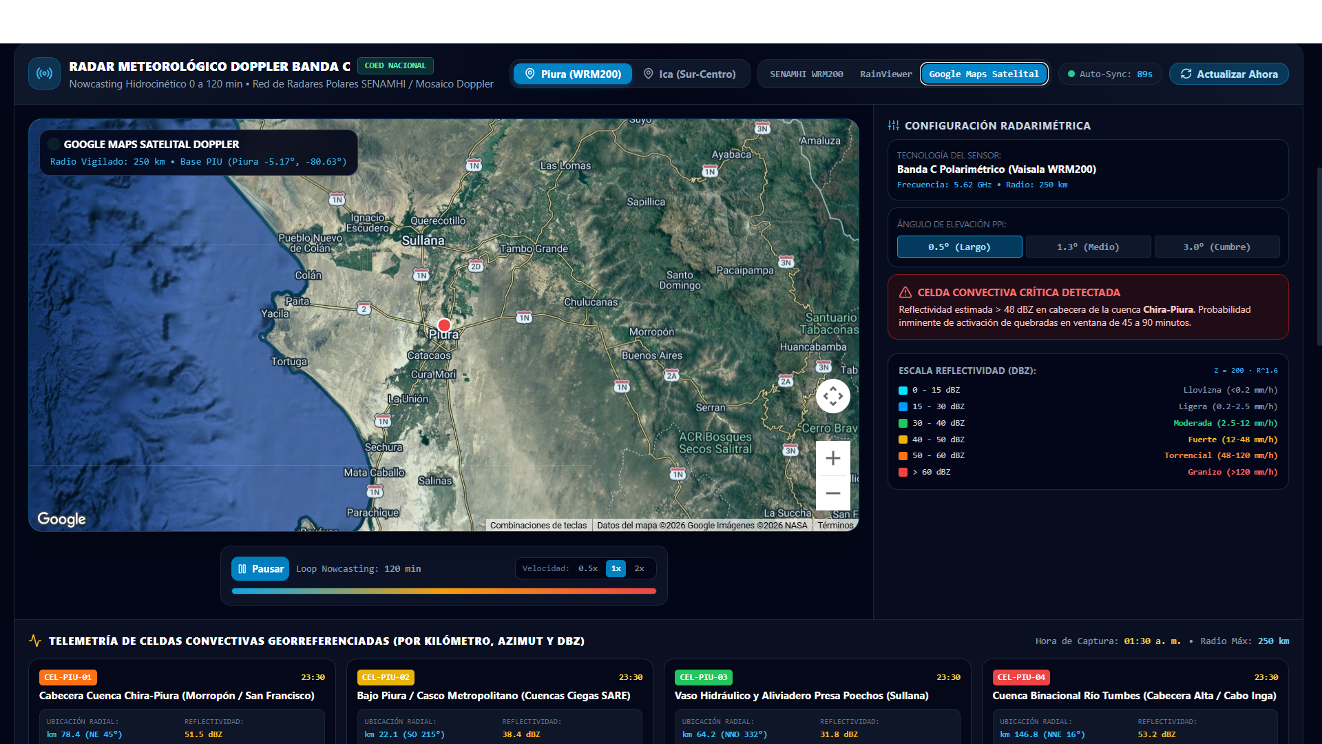
Autonomous Climate Multi-Agent Fusion: Six sovereign AI agents (Kuraq, Yupaq, Qilqay, Fiscalizador, Comunitario, Satelital) continuously ingest and cross-correlate NASA FIRMS (VIIRS 375m & MODIS), Sentinel-3 SLSTR, NOAA Sea Surface Temperature anomalies, Doppler radar, Open-Meteo IFS weather feeds, and official risk catalogs. Geodesic C2 Wildfire & Blind Fire Engine (/incendios): Geodesic DBSCAN Clustering ($R = 12\text{ km}$): Aggregates thousands of raw satellite thermal hotspots into active national wildfire clusters. Multi-Temporal Thermal Persistence (PTT 48h): Employs state-machine persistence to maintain active incident tracking even during optical cloud occlusion or nighttime inversion, preventing dangerous false negatives. Ground-Truth Cross-Validation & Detecting Administrative Blind Spots: Correlates satellite clusters against official civil defense reports. While ground field forms require on-site personnel and report hours or days post-event, AMARU highlights confirmed incidents while identifying remote "blind" thermal clusters (high-FRP fire activity raging in inaccessible topography absent from traditional field registries). Automated Heavy Machinery Dossiers: Calculates mechanized firebreak length and generates compliant emergency procurement orders under public procurement price ceilings. Parametric Evidence for Agricultural Relief & Insurance (SAC): Operates under a strict Human-in-the-Loop (HITL) and Off-Chain Data Protection boundary: AMARU does not hold citizen plaintext PII nor disburse funds directly. It outputs standardized OASIS CAP v1.2 geospatial damage dossiers (hectares burned, Fire Radiative Power, perimeter polygons). These tamper-proof dossiers allow regional Agrarian Agencies to validate catastrophe claims in hours rather than months, authorizing insurers to indemnified impacted smallholder farmers directly. Triple-Layer Cryptographic Trust Engine & Blockchain Notary: Layer 1 (Edge Micro-Proofs): Generates local SHA-256 telemetry hashes at municipal edge servers in $< 2\text{ ms}$, ensuring zero-latency offline operation during grid blackouts. Layer 2 (WORM Anti-Corruption Ledger): Write-Once-Read-Many cryptographic audit ledger with RFC 3161 timestamps and ISO 27037 chain of custody, benchmarking machinery rental rates against national procurement records. Layer 3 (Polygon Blockchain Anchor): Batches event hashes into balanced Merkle Trees and commits the 32-byte Merkle root onto the Polygon Amoy EVM network (ClimateAuditAnchor.sol, ChainID 80002), providing immutable public notary proof. Open Climate Data Oracle: Delivers public, certified Open API REST endpoints for international researchers, carbon auditors, and emergency responders. Testing & Validation: Peru as a Living Climate Laboratory To validate this universal architecture under the most severe real-world conditions, Peru serves as our natural testing ground, capturing the Compound Climate Dipole (ENSO Multi-Hazard):
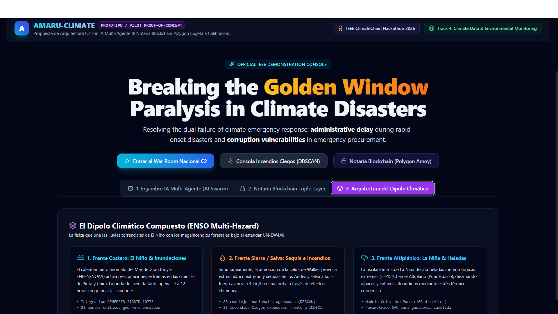
Coastal Front (El Niño & Flash Floods): Convective cloudbursts striking the Piura and Chira river basins within 4-to-12-hour hydrological concentration windows (CENEPRED SIGRID integration over 23 critical streams). Sierra & Rainforest Front (Drought & Megafires): Walker cell disruption driving severe drought where AMARU identified remote wildfire complexes spreading at 4 km/h in inaccessible slopes. Altiplano Cryospheric Front (La Niña & Extreme Freeze): Sudden cryogenic freeze waves (< -15°C) threatening camelid livestock in Puno, backed by parametric evidence dossiers. How we built it Smart Contract & Web3: Custom Solidity contract ClimateAuditAnchor.sol deployed and verified on Polygon Amoy (0x5462C7F1aC5a0C58356A21e25F883d6aF92289c0), storing Merkle roots, incident counters, and block-range metadata. Backend Architecture: Python 3.12, FastAPI, Web3.py, PyCryptodome, and geodesic Haversine clustering routines optimized for low-latency spatial queries. Frontend Tactical C2 Interface: Next.js 14 App Router, TypeScript, Tailwind CSS, Lucide icons, and interactive Leaflet/Google Maps geospatial viewports designed for crisis room operations. Cloud Infrastructure: High-availability serverless containers deployed on Google Cloud Run in us-central1 with automated container builds via Google Cloud Build. Data Integrations: NASA FIRMS API, Open-Meteo Global Ensemble (ECMWF IFS 9km), CENEPRED SIGRID risk plans, MEF Consulta Amigable (SIAF), INDECI emergency bulletins, and NOAA Coral Reef Watch SST. Challenges we ran into Cartographic Discrepancies: Municipal risk assessments often use UTM Zone 17S projections with manual cartographic annotations. We built an automated parser that transforms these coordinates into WGS84 standards with 650m tolerance buffers for satellite alignment. Emergency Speed vs. Blockchain Latency: Disaster command centers cannot wait 15–30 seconds for block confirmations. Our Triple-Layer architecture solves this: Layer 1 executes locally in $< 2\text{ ms}$, Layer 2 records into the append-only WORM ledger instantaneously, and Layer 3 periodically anchors the balanced Merkle root onto Polygon. Strict Separation of Public Authority (HITL): Financial disbursements in public administration cannot and should not be replaced by automated smart contract payouts due to constitutional and legal requirements. We solved this by enforcing Cognitive Caging: AI generates alerts in PENDING_HUMAN_SIGNATURE status, requiring verified human digital credentials before broadcast. Accomplishments that we're proud of Deployed and verified ClimateAuditAnchor.sol on Polygon Amoy, achieving 100% automated Merkle root notarization from live satellite feeds. Successfully demonstrated satellite-ground cross-validation in Peru, detecting unrecorded remote thermal clusters to assist emergency dispatchers. Implemented the full C2 Wildfire Module with zero TypeScript errors across 41 production routes on Google Cloud Run. Formulated an actionable parametric bridge for disaster relief, enabling transparent indemnification for vulnerable smallholder farmers. What we learned Digitizing paper forms into mobile apps is only step one for civil defense; the true paradigm shift is closing the latency gap between orbital satellite telemetry and ground operations through autonomous AI orchestration before disaster strikes. Blockchain’s greatest impact in climate resilience is not speculative tokens, but immutable institutional accountability and legal protection for frontline responders. Parametric disaster response and Early Action Protocols (EAPs) can reduce post-disaster expenditure by up to 40% when evidence is mathematically certified, unalterable, and synchronized with official state registries. What's next for AMARU-GLOBAL Global Deployment with WMO & UNDRR: Expand open API connectors with the WMO Global Data Store and Copernicus Open Access Hub to scale from the Andean-Pacific corridor to Southeast Asia and the Caribbean. Zero-Knowledge (zk-SNARK) Parametric Claims: Upgrade our privacy module to zk-SNARK proofs on Polygon, allowing farmers and agrarian cooperatives to prove eligibility for climate insurance without exposing personal identifying information. Cross-Border Early Action Corridors: Establish multi-jurisdiction Early Action Protocols under the UN Early Warnings for All (EW4All) initiative to coordinate cross-border logistics during regional climate catastrophes. ⚠️ Academic Prototype & Institutional Disclaimer AMARU-GLOBAL is an independent, non-governmental proof-of-concept software prototype developed exclusively for the IEEE ClimateChain Global Hackathon 2026. It is not an official portal of the Government of Peru nor legally affiliated with INDECI, COEN, SENAMHI, or any ministry or public agency. It processes publicly available open scientific data for demonstration, research, and algorithmic evaluation purposes only.
Built With
- ai
- blockchain
- climate-data
- cybersecurity
- disaster-risk-reduction
- fastapi
- gis
- google-cloud
- google-maps
- iot
- machine-learning
- multi-agent-systems
- nasa-firms
- nextjs
- open-meteo
- polygon
- python
- react
- smart-contracts
- solidity
- tailwindcss
- typescript

Log in or sign up for Devpost to join the conversation.