-
-
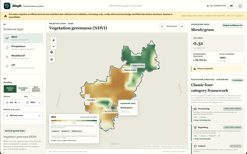
Relative NDVI reveals vegetation patterns while keeping ecosystem-service claims and evidence limits explicit.
-
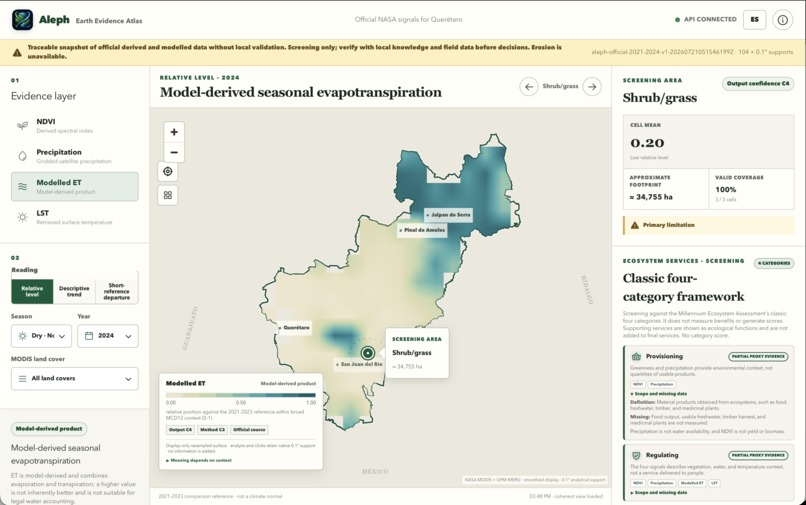
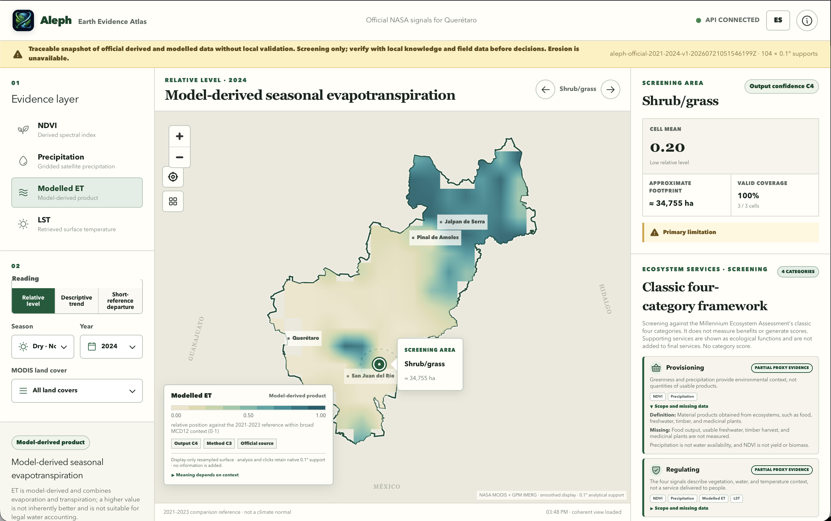
Modeled evapotranspiration highlights seasonal land–water signals without implying direct water accounting.
-
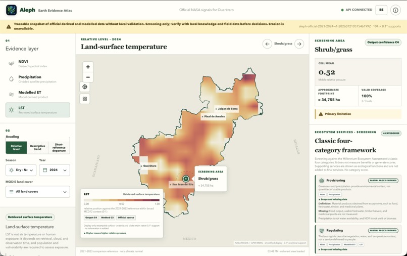
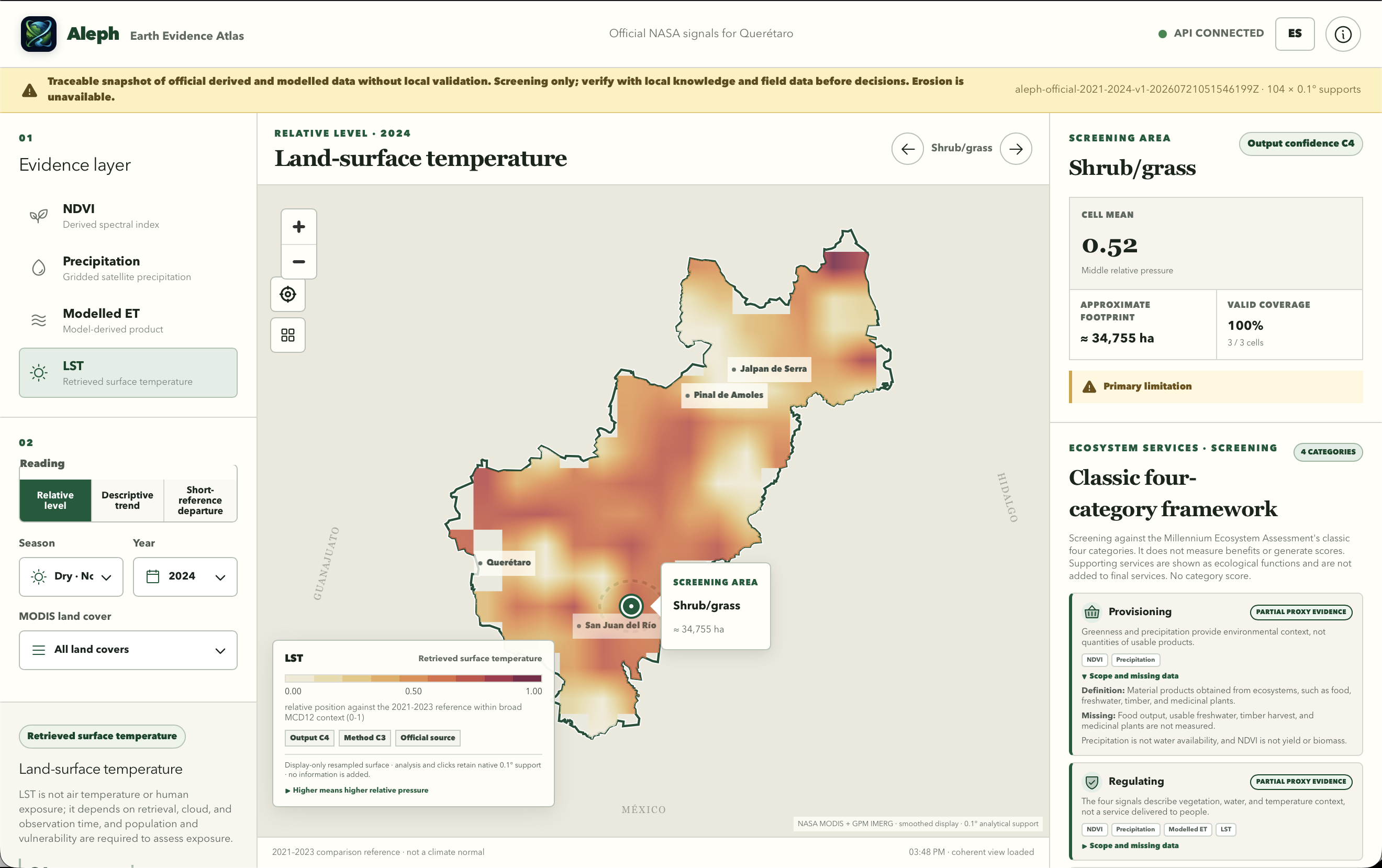
Land-surface temperature maps relative heat pressure while distinguishing surface temperature from human exposure.
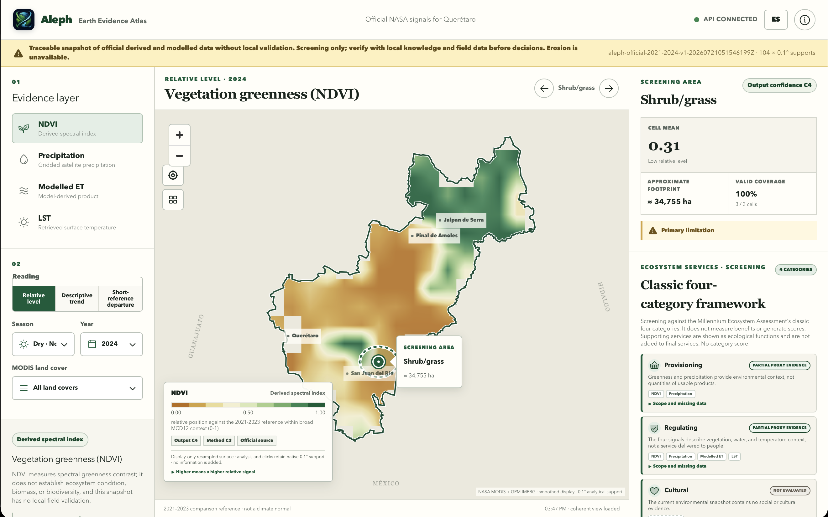
Aleph — Earth Evidence Atlas
Inspiration
Environmental decisions are often made from dashboards that look precise but hide a fundamental question: what does the evidence actually support?
Satellite-derived indicators are powerful, but they are often presented as if they directly measure ecosystem health, biodiversity, water availability, or economic value. In reality, many are proxies or modelled estimates whose interpretation depends on ecological context, scale, season, methodology, and local validation.
Ecosystem-service assessments face an additional problem: environmental condition is frequently confused with the benefits ecosystems ultimately provide to people. Greenness may support an interpretation of vegetation condition, but it is not food production, carbon storage, biodiversity, or ecosystem value. Precipitation is not water availability. Evapotranspiration is not a water meter. Land-surface temperature is not human heat exposure.
We built Aleph to explore a more honest approach to ecosystem-service intelligence: an interactive Earth evidence atlas that connects environmental signals to the classic ecosystem-services framework while keeping evidence, interpretation, confidence, missing information, and limitations visible.
Querétaro, Mexico, became our demonstration territory because it contains exceptional environmental diversity within one state—from the forests of the Sierra Gorda to semiarid shrublands, irrigated agricultural areas, rapidly expanding cities, volcanic highlands, and aquatic systems. The same environmental signal can mean very different things across these landscapes, so Aleph emphasizes ecological and land-cover context rather than applying one universal interpretation.
What Aleph does
Aleph is an interactive ecosystem-services screening atlas for exploring environmental condition, change, and short-reference departures across Querétaro.
Users can:
- Explore official satellite-derived, retrieved, gridded, and modelled environmental signals.
- Switch between vegetation greenness, precipitation, modelled evapotranspiration, and land-surface temperature.
- Compare relative levels, descriptive trends, and departures from a recent reference period.
- Change season, year, and land-cover context.
- Select screening areas and inspect their values, footprint, valid coverage, confidence, and primary limitations.
- Review how each signal relates to provisioning, regulating, cultural, and supporting ecosystem services.
- See which ecosystem-service categories have partial proxy evidence and which remain unevaluated.
- Compare multiple environmental signals without collapsing them into a misleading total score.
- Generate evidence-grounded interpretations and decision-ready summaries with AI.
- See persistent warnings whenever an output is a proxy, modelled estimate, contextual indicator, or screening-only result.
Aleph does not claim to measure final ecosystem services directly. Its environmental layers provide partial evidence about ecological conditions and functions that may support services, but they do not establish the quantity of benefits delivered to people.
For example, Aleph does not present NDVI as biodiversity, biomass, food production, or carbon storage. It does not treat precipitation as usable freshwater, modelled evapotranspiration as legal water accounting, or land-surface temperature as direct human exposure. It also avoids converting uncertain environmental indicators into unsupported monetary values.
Its purpose is to help users understand:
- What the available Earth-observation evidence suggests.
- Which ecosystem-service categories that evidence may inform.
- How strongly the evidence supports the interpretation.
- Which variables and local data are still missing.
- What requires field validation or additional analysis before a real decision is made.
Scientific principles
Four principles guided the project:
1. A spectral index is not an ecosystem service
Vegetation indices measure spectral contrast. They can support interpretations of vegetation condition, but they do not directly measure biodiversity, biomass, carbon storage, agricultural yield, or ecosystem value.
2. Condition, function, service, flow, and value are different concepts
The condition of an ecosystem is not the same as the ecological function it performs, the service it can potentially supply, the benefit people actually receive, or its monetary value.
Aleph keeps these concepts separate. The current system screens environmental condition and partial proxy evidence; it does not claim to quantify final service flows or economic value.
3. Ecosystem services should not be reduced to one score
Provisioning, regulating, cultural, and supporting services represent different relationships between ecosystems and society. Combining them into one number would hide trade-offs, double-count correlated indicators, and imply value judgments that the available data cannot support.
Aleph therefore presents the four categories independently and clearly identifies missing evidence.
4. Every output carries uncertainty
Each output includes an evidence class, methodological context, confidence level, and visible caveat. No map colour, ecosystem-service interpretation, or AI-generated statement should appear without explaining how much evidentiary weight it can reasonably carry.
Ecosystem-services framework
Aleph uses the classic four-category framework associated with the Millennium Ecosystem Assessment:
Provisioning services
Material products obtained from ecosystems, including food, freshwater, timber, and medicinal resources.
Aleph currently provides only partial environmental context through greenness and precipitation. These signals do not establish crop yield, usable freshwater, timber production, or harvested products.
Regulating services
Benefits associated with ecosystem processes such as climate regulation, water regulation, erosion control, and temperature moderation.
NDVI, precipitation, modelled evapotranspiration, and land-surface temperature can provide partial proxy evidence about regulating conditions. They do not directly measure the benefit delivered to people.
Cultural services
Non-material benefits such as recreation, identity, heritage, education, and spiritual value.
These services require social, cultural, accessibility, and participatory data. They are therefore marked as not evaluated rather than inferred from satellite imagery.
Supporting services
Ecological functions such as primary productivity, habitat formation, nutrient cycling, and soil formation that underpin other services.
Vegetation signals may provide partial evidence about ecological condition, but Aleph does not convert greenness directly into habitat quality, biodiversity, or complete ecosystem functioning.
This framework is presented as a screening structure, not as a complete ecosystem-services assessment.
How we built it
Aleph was built as a single-page geospatial web experience centered on a map of Querétaro.
The interface combines:
- A map-based Earth evidence explorer.
- Independent layers for NDVI, precipitation, modelled evapotranspiration, and land-surface temperature.
- Seasonal and annual controls.
- Relative-level, descriptive-trend, and short-reference-departure reading modes.
- Land-cover and screening-area selection.
- Per-area statistics, valid-coverage reporting, and approximate footprint calculations.
- A four-category ecosystem-services screening framework.
- Explicit labels for partial proxy evidence, missing data, and unevaluated categories.
- A confidence framework that distinguishes source quality, method quality, output confidence, and primary limitations.
- An AI reasoning layer that translates computed facts into concise explanations without inventing unsupported numbers.
The system keeps the data source, analysis logic, ecosystem-service interpretation, interface, and AI layer separate. This allows future versions to replace or expand the environmental evidence without rebuilding the complete product experience.
For the hackathon, we prioritized a polished and coherent end-to-end demonstration while preserving scientific traceability. The interface identifies whether each layer is derived, retrieved, gridded, or modelled and persistently states that Aleph is a screening tool without local field validation.
AI grounding
Aleph uses GPT-5.6 as an interpretation layer rather than as the source of environmental measurements or ecosystem-service claims.
Before generating a response, the application computes structured facts from the active map state, including:
- Selected evidence layer.
- Reading mode.
- Year and season.
- Selected land cover or screening area.
- Relative value or departure.
- Valid data coverage.
- Approximate footprint.
- Source and methodological classification.
- Output confidence.
- Primary limitation.
- Relevant ecosystem-service categories.
- Missing evidence required for a fuller assessment.
Only those computed facts are provided to the model. The assistant is instructed to:
- Answer only from the supplied evidence.
- Avoid introducing unsupported numbers.
- Distinguish observations, proxies, modelled products, ecological functions, and final services.
- Never infer ecosystem-service flow or value without supporting data.
- State confidence and methodological limitations.
- Identify missing evidence.
- Respond in the user’s language.
- Remind users that local verification may still be necessary.
This makes the AI a translator of evidence and limitations—not an oracle.
Challenges we faced
Connecting environmental signals to ecosystem services without overstating them
The largest scientific challenge was showing ecosystem services without implying that four satellite-derived variables could measure complete service delivery.
We addressed this by presenting ecosystem services as a screening framework. Each category shows the available proxy evidence, its scope, what it may help interpret, and which critical data remain missing.
Making uncertainty understandable
Confidence systems can easily become too technical or too vague. We needed to communicate uncertainty in a way that was scientifically meaningful but still understandable during a short interaction.
We addressed this through compact confidence badges, source labels, method classifications, persistent warnings, primary-limitation panels, and short explanations of what each signal means—and what it does not mean.
Avoiding a misleading ecosystem-services score
It would have been visually simple to combine all environmental variables and service categories into one overall score. However, that would hide trade-offs, double-count related indicators, and imply weighting choices that the evidence cannot justify.
Instead, Aleph keeps evidence layers and service categories independent. A territory may show high vegetation greenness while also presenting high surface-temperature pressure or modelled water demand. These signals require contextual interpretation, not automatic averaging.
Representing missing data honestly
Some ecosystem services—especially cultural services—cannot be responsibly evaluated from the available Earth-observation layers.
Rather than fabricate an estimate, Aleph explicitly marks them as not evaluated and identifies the social, cultural, accessibility, or field data that would be needed.
Comparing ecologically different territories
Querétaro contains forests, shrublands, cities, agricultural areas, and aquatic environments. Applying a universal interpretation would make naturally dry landscapes appear degraded merely because they are less green than forests.
The interface therefore emphasizes land-cover and ecological context when interpreting relative environmental signals.
Balancing visual quality with scientific honesty
Hackathon products need to be immediately understandable and visually compelling. Environmental science, however, requires caveats, careful language, and clear boundaries around inference.
Our challenge was to make scientific restraint part of the visual experience instead of hiding it in documentation. The warning banner, confidence system, ecosystem-service evidence labels, source classifications, and limitation panels are therefore central product elements.
Working within limited time
We had only a few days to move from concept to a functional, presentation-ready system. We focused on a defensible set of environmental signals, a transparent ecosystem-services framework, a clear interaction model, and a polished demonstration rather than attempting to recreate a complete operational environmental-monitoring platform.
What we learned
We learned that ecosystem-service tools become more trustworthy when they clearly distinguish environmental condition from ecological functions and human benefits.
We also learned that missing evidence is itself useful information. Explicitly showing that a service has not been evaluated can be more valuable than producing a weak or misleading estimate.
Scientific honesty does not have to weaken a product experience. When uncertainty, evidence classes, and missing information are designed clearly, they can increase trust and help users understand what decisions the data can reasonably support.
We also found that the most valuable role for a language model in environmental decision support is not generating more claims. It is helping people navigate existing evidence, understand methodological limits, recognize missing information, and translate complex spatial analysis into accessible language.
Finally, environmental indicators become much more useful when they are connected through a transparent ecosystem-services framework rather than displayed as isolated maps.
What is next
The next version of Aleph could include:
- Local validation using Mexican environmental and field datasets.
- Higher-resolution analysis by municipality, watershed, community, or property.
- Direct water-persistence and surface-water indicators.
- Calibrated erosion-risk screening.
- Land-cover and ecological-condition change detection.
- Biodiversity, habitat, soil, and restoration evidence layers.
- Agricultural production and usable-water data for stronger provisioning-service assessments.
- Demographic and exposure data for human-centered regulating-service analysis.
- Participatory and cultural datasets for recreation, identity, heritage, and accessibility.
- Historical trend significance and uncertainty intervals.
- Decision briefs exportable as traceable PDF documents.
- A production data pipeline using Google Earth Engine, NASA products, and official Mexican sources.
- Expansion from Querétaro to other territories.
Aleph began as a Build Week project, but its larger vision is simple:
Make ecosystem-service intelligence easier to explore without hiding what the evidence can—and cannot—support.
Built With
- artificial-intelligence
- codex
- geospatial
- gpt-5.6
- nasa
- react
- remote-sensing
- sol
- sustainability
- typescript

Log in or sign up for Devpost to join the conversation.