Inspiration
Static maps are reactive—they tell you a jam exists only after you’re stuck in it. In cities like Ho Chi Minh City, "Ghost Variables" like flash floods, sudden accidents reported on FM radio, or localized social media alerts stay hidden from standard APIs. We wanted to build a "City Brain" that senses the world like a human but reacts with the precision of a supercomputer.
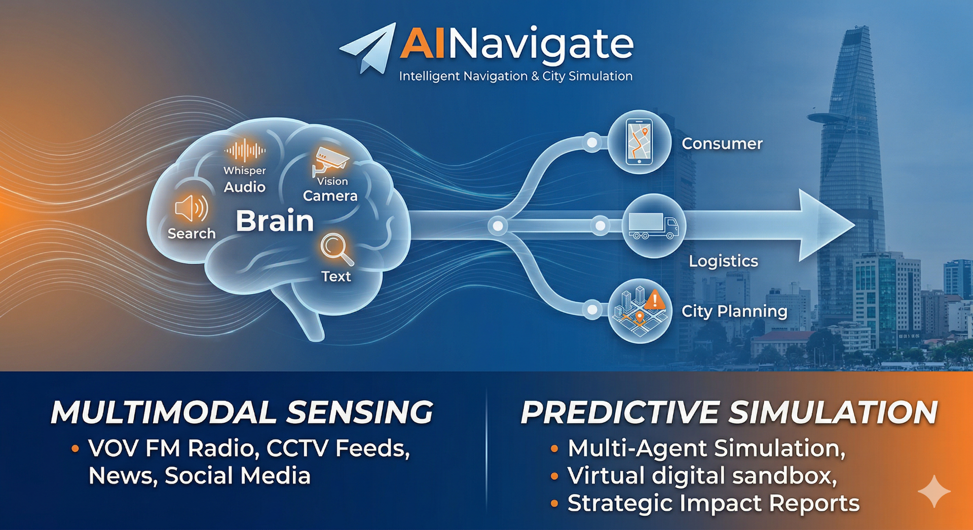
What it does
AINavigate is an intelligent navigation and simulation platform. It collects real-world data from news, FM radio, social media, and CCTV imagery to bypass hazards that standard maps miss. Beyond routing, it uses Multi-Agent Simulation (MAS) to virtually coordinate thousands of vehicles, allowing logistics companies and city planners to predict bottlenecks and test infrastructure in a risk-free digital sandbox.
How we built it
We built a Multi-Agent "City Brain" using OpenAI’s GPT-4o as the core reasoning engine. The architecture consists of four specialized agents:
- Media Agent: Uses Whisper to "listen" to FM radio and Vision to "see" CCTV flood images, converting sights and sounds into traffic alerts.
- Query Agent: Performs precise domestic and international web searches via Firecrawl to find "Ghost Variables" like social media reports or hidden road closures.
- Insight Agent: Uses LlamaIndex to mine private historical databases, finding predictive patterns in how the city reacts to past weather.
- Report Agent: Collects the final consensus to generate structured Full-Scale View strategies and professional PDF reports.
- These agents "debate" in a Redis-backed ForumEngine to resolve data conflicts and ensure the most accurate navigation strategy.
Challenges we ran into
- Data Collection Hurdles: Gathering real-time, non-traditional data was our biggest obstacle. Automating the "collection" of live FM radio streams via Whisper and scraping fragmented social media reports required building custom scrapers that could filter out noise and extract precise location coordinates.
- Rapid Implementation: We had to architect a complex Multi-Agent System from scratch in a very short timeframe. Coordinating four specialized agents, a Redis-backed ForumEngine, and a Simulation Engine into a single functional demo required intense, high-speed engineering to ensure the agents could "debate" and reach a consensus in seconds.
Accomplishments that we're proud of
Accomplishments that we're proud of
- Tackling the Right Business Problem: We successfully identified a massive gap in the market—standard navigation apps are reactive and miss "hidden" variables. By focusing on Logistics and City Planning, we addressed a high-value problem that impacts both the economy and daily urban life.
- Research & Design Success: We successfully researched and architected a complex Multimodal Multi-Agent System. Moving from a conceptual "City Brain" to a structured, four-agent environment that "debates" data points was a major technical milestone for our team.
- Functional Demo Release: Despite the technical complexity, we released a working demo that proves our agents can ingest live FM audio and CCTV images to generate real-time routing strategies and professional reports.
What we learned
- Multi-Agent Resilience: Specialized agents handle conflicting urban data better than a single-model approach.
- Value in "Noise": Critical traffic updates are often buried in FM radio and social media, not official APIs.
- Simulation Power: The real value for enterprise is the "Digital Twin" ability to simulate thousands of vehicles.
What's next for AINavigate
We are heading toward a full release to support daily users, logistics firms, and city governments. We aim to scale our simulation tools to help cities virtually test new infrastructure before building it.
Built With
- amazon-web-services
- claudecode
- cursor
- elevenlabs
- loveable
- openrouter
- solo
- tinyfish
- typescript

Log in or sign up for Devpost to join the conversation.