-
-
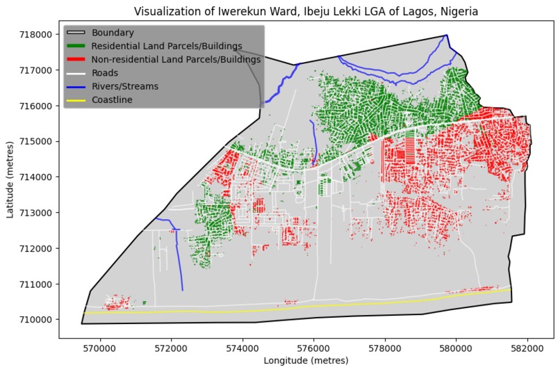
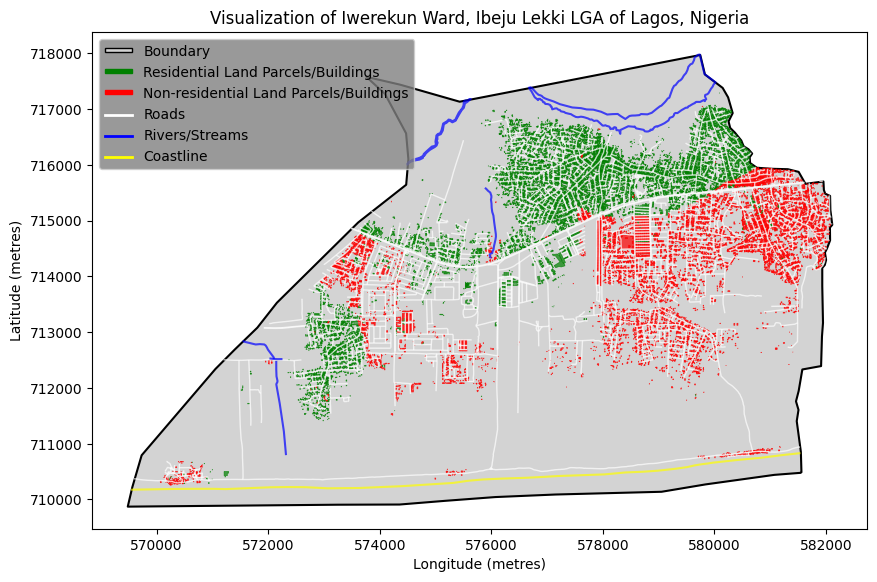
Iwerekun 1 ward AHP-produced residential suitability
-
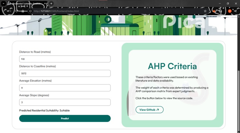
Predicted Residential Suitability of a Building

Topic: Integrating Artificial Intelligence, Geographic Information Systems (GIS) and Multi-Criteria Decision Analysis for Land Use Suitability Analysis (MCDA) in Urban Planning: A Case Study of Lagos State, Nigeria
Inspiration
The prevalence of informal settlements and the recurring impact of flooding present significant challenges in Lagos, Nigeria, particularly in rapidly urbanizing areas. This is mainly due to inadequate planning and failure to implement planning policies. Furthermore, traditional methods of urban and land use planning can be time-consuming, and efficient identification of urban land use categories for land use suitability poses a major gap in urban research.
Definition of key terms
- Analytic Hierarchical Process (AHP): An MCDA technique that breaks down complex problems into a hierarchy of criteria and alternatives, and makes use of a pairwise comparison matrix to systematically derive criteria weights.
- Geographic Information System (GIS): A set of hardware and software tools that allow users to capture, store, analyse, manage, and visualise geographic data related to the Earth.
- Land Use Suitability Analysis: The process of assessing and classifying an area or parcel of land for a specific type of use (residential, agriculture, industrial, etc.).
- Multi-Criteria Decision Analysis (MCDA): A set of structured processes for solving complex decision problems, involving the weighting of criteria and their trade-offs to determine an optimal decision.
What it does
The project offers a framework to produce well-planned cities by enabling easier suitability classification for residential land use through Artificial Intelligence. This framework is not only applicable to Ibeju-Lekki, but also adaptable to other global regions.
How we built it
This research adapts Abdulla's (2023) hybrid MCDA-AI framework for land use suitability analysis in Iwerekun 1 ward, Ibeju-Lekki LGA, Lagos, chosen due to its identified underutilized land. The study primarily employed the Analytic Hierarchical Process (AHP) for its MCDA component, noting its common use in GIS-MCDA integration. Key AHP criteria, also serving as AI training features, included distance to road, river, and coastline, as well as slope and elevation. Rainfall data was excluded due to its low resolution. Expert opinions on land use suitability were aggregated via the geometric mean to form the AHP pairwise comparison matrix, from which criterion weights were calculated using the eigenvalue method. After collecting and merging building and criterion datasets in QGIS, each building received a total suitability score calculated by multiplying individual criterion scores by their respective weights. These total scores were normalized to a 0-1 range, classifying buildings with scores from 0.5 to 1 as suitable for residential use, and 0 to 0.4 as unsuitable.
The dataset was split 70/30 for training and testing three AI models: Logistic Regression, XGBoost Classifier, and Random Forest Classifier. Initial training revealed overfitting, with 99-100% accuracy, due to the "distance to river" feature acting as a "cheating variable." This feature was subsequently removed, leading to improved model performance.
Finally, a FastAPI backend was developed to expose an endpoint for the best-performing model, the Random Forest Classifier, enabling it to predict residential suitability based on user-provided features from an HTML, CSS, and JavaScript frontend. A JavaScript function was implemented to send user inputs to this backend endpoint.
Challenges we ran into
The major challenge was lack of data availability for land parcels as land use suitability is typically done on these parcels. Buildings were used as proxies for these parcels. Another limitation identified was the absence of established suitability scales for the criteria used for residential land use analysis within the local context. Scales from relevant literature were used instead. Land use suitability analysis also depends on multiple criteria, however, data availability for certain relevant criteria posed a significant constraint.
Accomplishments that we're proud of
- Being able to learn about Geospatial Analysis and Geographic Information Systems
- An understanding of the Analytic Hierarchical Process (AHP) MCDA technique.
- Being able to integrate the hybrid use of AI, GIS, and MCDA to develop the system.
What we learned
It would be best to use land parcels instead of building records for proper land use suitability. This is because the buildings were densely clustered and lead to very similar attributes/criteria values among adjacent building structures. This issue is believed to have later contributed to the observed data leakage of the ‘distance to river’ criterion. The use of land parcels would then confirm the utmost implementation of the system.
What's next for AI, GIS and MCDA for Urban Land Use Suitability
Hopefully, being able to collaborate with experts to obtain land parcel datasets for labelling and AI training.

Log in or sign up for Devpost to join the conversation.