Inspiration
India’s farming system is highly diverse, with small and fragmented farmlands, irregular weather patterns, and region-specific crop calendars. Unlike large farms in the US or Europe, Indian farmers face challenges in adopting advanced technology. We were inspired to design AgriVision as a concept that could bridge the gap between modern AI tools and the real needs of smallholder farmers.
What it does
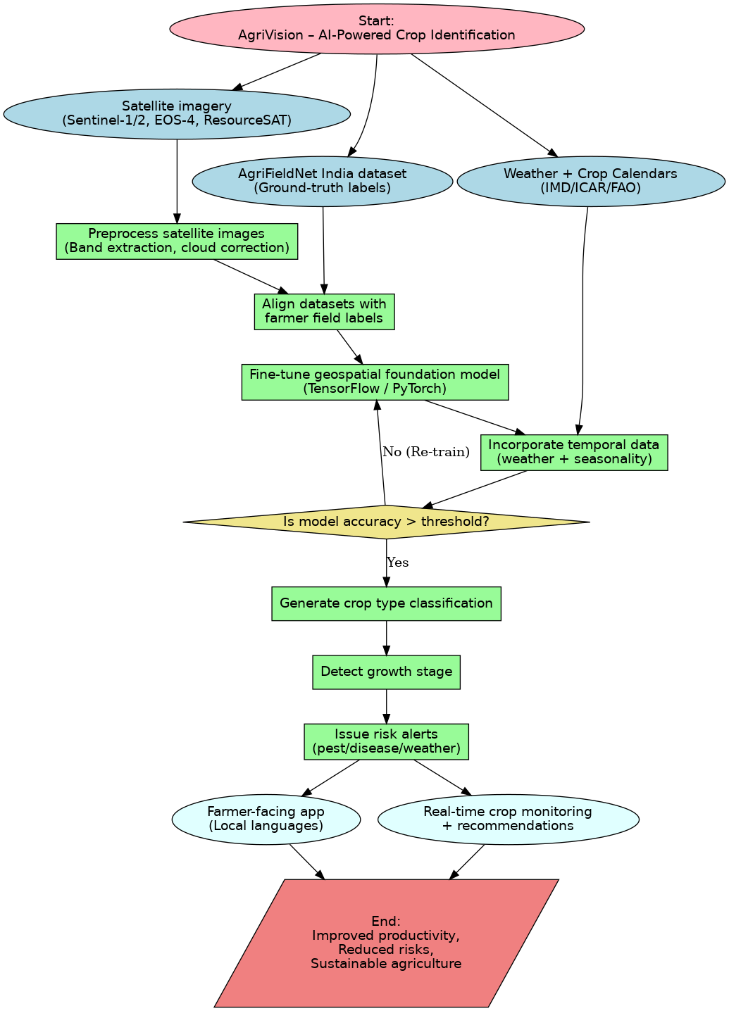
AgriVision is an idea for an AI-powered system that can identify crops using satellite imagery and agricultural data. The goal is to:
Detect which crop is being grown on small plots of land
Monitor crop growth stages
Give alerts about risks like bad weather or crop stress
Provide farmer-friendly recommendations in local languages
How we plan to build it
Data Sources
Satellite imagery (Sentinel-1/2, ResourceSAT-2/2A, EOS-4)
AgriFieldNet India dataset for crop labels
Weather data (IMD/API) and ICAR/FAO crop calendars
Preprocessing (planned)
Cleaning satellite images, cloud correction, aligning them with field labels
Model Development (planned)
Use geospatial AI models and fine-tune them on Indian datasets
Combine with weather and seasonal data for better accuracy
Deployment (future idea)
A mobile app or portal for farmers in multiple regional languages
Challenges
Fragmented farmland boundaries make classification harder
Cloud cover reduces image clarity
Need for models to generalize across India’s different states and climates
Making the technology simple enough for farmers to actually use
What we learned
Even though we haven’t built the model yet, we learned a lot while designing the approach:
How satellite and weather data can be combined for agriculture
The importance of making tools accessible in local languages
The value of building solutions specific to India’s unique farming system
What’s next
Build the first prototype of the model using the mentioned datasets
Test on small regions to validate accuracy
Add more crop varieties and expand to multiple states
Partner with agricultural institutions and government bodies for scaling
Built With
Languages/Frameworks (planned): Python, TensorFlow, PyTorch
Tools: Google Colab, Kaggle, Jupyter Notebook
Libraries: NumPy, Pandas, Scikit-learn, HuggingFace Transformers, OpenCV, Rasterio, GDAL
Datasets: AgriFieldNet India, Sentinel-1 SAR, Sentinel-2 multispectral, ResourceSAT-2/2A, EOS-4, IMD weather datasets, ICAR/FAO crop calendars
Built With
- crop
- eos-4
- gdal-datasets:-agrifieldnet-india
- huggingface-transformers
- icar/fao
- imd-weather-datasets
- jupyter-notebook-libraries:-numpy
- kaggle
- languages/frameworks-(planned):-python
- opencv
- pandas
- pytorch-tools:-google-colab
- rasterio
- resourcesat-2/2a
- scikit-learn
- sentinel-1-sar
- sentinel-2-multispectral
- tensorflow

Log in or sign up for Devpost to join the conversation.