-
-
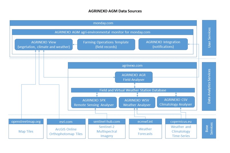
AGRINEXO AGM Data Sources
Inspiration
Half of the world’s habitable land is used for agriculture. Pastures used for grazing and land used to grow crops, have an immense impact in the carbon cycle, in the water cycle and in biodiversity.
With the current technologies there a number of conflicting goals, that are extremely difficult to balance and conciliate. Soil is a major reservoir of carbon and while any loss of soil organic carbon content results in increased CO2 atmospheric concentrations, tillage is required to control weeds and prepare the land for crops. Over irrigation and the misuse of fertilizers and pesticides present a major risk to the quality and availability of freshwater, but any loss of primary productivity would require the further expansion of the land used for agriculture, with increased environmental impacts and an inherent loss in biodiversity.
In 2018, agriculture and related land use emissions accounted for 17 percent of global GHG emissions from all sectors [1]. Optimizing farming operations from an agroecological perspective considering all agroecosystem services (agricultural production, climate regulation, soil and water conservation, habitat maintenance, and landscape aesthetics), requires efficient land use and efficient energy use.
The path towards sustainable agricultural systems depends on the implementation of a wide range of solutions to optimize resource usage and adapt to climate change.
Sustainable agriculture entails producing quality foods while improving the living standards of rural communities and protecting the environment. Agricultural commodity markets are global, but production is achieved locally under a wide range of edaphoclimatic constraints and social contexts. No size fits all.
The availability of relevant and accurate information increases the ability of individual farmers and technicians to make appropriate decisions. AGRINEXO AGM is being developed to contribute to improve the environmental sustainability of agricultural and forestry activities.
Even though there is an obvious global warming trend, climate is changing in a different way for each region, with varying impacts in agriculture. The growing global population demands higher levels of food production, putting additional pressure on the farming systems worldwide. A comprehensive understanding of local climate change is critical to enable for an effective adaptation of the agricultural production systems, mainly for those adversely impacted.
In Portugal, for example, the climate has already warmed by 0.85 ºC in relation to the pre-industrial period, precipitation has fallen by 20–25 mm/decade, and intensified heat waves and droughts have aggravated water scarcity [2], requiring the adoption of cultivars adapted to emerging weather patterns and improved soil and water conservation practices, to allow for the sustainability of traditional crops as citrus, olive and grapevine.
What it does
AGRINEXO AGM is an agri-environmental monitor app, enabling for field vegetation and weather conditions monitoring, directly from monday.com boards. Using AGRINEXO agri-environmental monitor, you can access critical technical information as NDVI maps, climate analysis and weather condition forecasts, while managing the work of your team and contractors.
An efficient work organization backed up by accurate technical data is essential to achieve a consistent economic efficiency and to improve conservation practices. Monday.com allows for a flexible definition of the structure of your field records and you can link your field records to the climate and satellite imagery time-series provided by the AGRINEXO agri-environmental monitor, without unnecessary data and complexities.
How we built it: services architecture, algorithms and data sources.
AGRINEXO AGM app executes within the monday.com framework leveraging the information exchange between the operational records where tasks are planned and managed (field records kept as monday.com boards) and the records of agri-environmental conditions (vegetation, climate and weather information kept in the AGRINEXO view). The AGRINEXO Integration provides a mechanism to create notifications when new information derived from satellite imagery is available.

Weather forecasts presented in AGRINEXO AGM are derived from the ECMWF open data real-time forecasts available from the European Centre for Medium-Range Weather Forecasts (ECMWF) as open data. The base grid of the data source (0.4 degrees) is downscaled to a 0.25 degrees grid using triangular interpolation.
Weather data is derived from ERA5 hourly data on single levels from 1959 to present and climatic data is derived from ERA5 monthly averaged data on single levels from 1959 to present, both available from the Copernicus Climate Change Service as open data. The base grid of the data sources (0.25 degrees) is used directly to build the virtual weather station time-series.
Weather data is processed and presented using the time zone of the field location (considering the UTC offset in hours applicable on the 1st of July 2022).
NDVI maps are derived from Sentinel-2 multispectral imagery retrieved from sentinel-hub.com under a commercial license. Base imagery is analysed for validity to exclude large non vegetated areas and clouds, and subsequently polygonised using 0.1 intervals of NDVI to render as an interactive map.
Map tiles are retrieved from openstreetmap.org and available as open data. Orthophotomap tiles are retrieved from ArcGis Online and available under a commercial license with paid and free services tiers.
Reference evapotranspiration is computed using the Hargreaves–Samani Method [3]. Basal crop coefficients (KCB) are derived from NDVI using:
KCB = 1.09*NDVI + 0.07
which reflects a generic relationship estimated using the published results of the TOPS-SIMS project [4].
When additional crop parameters are defined according to standard irrigation planning procedures [3,5], the KCB inferred from the last available NDVI is assumed to evolve according to the standard KC curve, which is particularly useful when there is no usable satellite imagery due to continued cloud cover conditions. When no additional crop parameters are defined, the KCB is assumed constant for the forecast period.
Reported KCBs refer to the field as a whole and may appear lower than expected for permanent crops. Sentinel-2 multispectral imagery resolution does not allow for the distinction of crop rows and space between crop rows, therefore the reported Basal Crop Evapotranspiration (ETB) is an average of the entire field, although evapotranspiration occurs mainly in the crop rows.
Recordkeeping is critical to most agriculture certifications. Specific details of the required information and of the reporting procedures have some variations, according to the type of agricultural products and the specific objectives of the certification. However, records must fully disclose all activities and transactions of the certified operation in sufficient detail as to be readily understood and audited [6].
Field records is where most of the information regarding actual farming activity is kept [6]. The field activity log, or field record, should show all field preparation work, planting information, post planting fieldwork, dates and rates of all inputs, and harvest dates for each field.
A field log can be kept in several ways, the Farming Operations template is organized as a hierarchical table (one group per field-crop-year combination) where the master records are an overview of the operation (such as soil preparation, planting, pulverization, irrigation and harvesting) and the detail records include the specific inputs (such as seeds, manure, fertilizers, herbicides, pesticides, and water).
Labour hours and machine hours can also be recorded in the detail records and additional columns can be added to the template according to specific requirements. Field records can be exported to offline formats or printed, which is also commonly required for archiving and auditing past fields records.
What's next for AGRINEXO AGM
The current pre-release version implements limited internationalization features and current development efforts are addressing these limitations. The units system corresponds to those commonly used in the European Union and the user interface is in English.
We are also refining requirements with major stakeholders as farmers, agricultural engineers, equipment manufacturers and environmentalists, to improve the solution.
References
[1] "Emissions due to agriculture. Global, regional and country trends 2000–2018", FAOSTAT Analytical Brief Series No 18. Rome, FAO, 2020.
[2] S. Branquinho, J. Rolim and J. L. Teixeira, “Climate Change Adaptation Measures in the Irrigation of a Super-Intensive Olive Orchard in the South of Portugal”. MDPI, Basel, Switzerland, Agronomy 2021, 11, 1658.
[3] R. Allen, L. Pereira, D. Raes, and M. Smith, “Crop evapotranspiration: Guidelines for computing crop water requirements,” U.N. Food & Agriculture Org., Rome, Italy, FAO Irrigation and Drainage Paper #56, 1998.
[4] F. S. Melton, L. F. Johnson, C. P. Lund, L. L. Pierce, A. R. Michaelis, S. H. Hiatt, A. Guzman, D. D. Adhikari, A. J. Purdy, C. Rosevelt, P. Votava, T. J. Trout, B. Temesgen, K. Frame, E. J. Sheffner, and R. R. Nemani, "Satellite Irrigation Management Support With the Terrestrial Observation and Prediction System: A Framework for Integration of Satellite and Surface Observations to Support Improvements in Agricultural Water Resource Management," in IEEE Journal of Selected Topics in Applied Earth Observations and Remote Sensing, vol. 5, no. 6, pp. 1709-1721, Dec. 2012.
[5] C. Brouwer and M. Heibloem, "Irrigation Water Needs", Irrigation Water Management, Training manual no. 3, Rome, FAO, 1986.
[6] https://content.ces.ncsu.edu/north-carolina-organic-commodities-production-guide/chapter-12-organic-certification (retrieved 20-09-2022). M. Hamilton, J. Riddle and A. G. Stafford. North Carolina Organic Commodities Production Guide (Chapter 12: Organic Certification). N.C. State Extension. June, 2019.
Built With
- agrinexo.com
- copernicus.eu
- ecmwf.int
- esri
- javascript
- monday.com
- openstreetmap


Log in or sign up for Devpost to join the conversation.