-
-
apppreview
-
apppreview
-
architecture
Inspiration
In India, the danger isn't the rare catastrophe — it's the ordinary journey home. Every day roughly 546 people die on Indian roads (NCRB 2023). In 2024, lightning killed 2,825 people, 96% of them in the open. During the 2025 monsoon, floods, cloudbursts and landslides killed over 2,700. In a single September 2025 Kolkata cloudburst, 9 of 12 deaths were electrocutions — live electrical poles standing in waterlogged streets. In 2023, a glacial-lake outburst in Sikkim killed 55 people downstream, hours after the trigger, kilometres away.
We kept noticing the same gap: navigation apps optimise for speed, and weather apps warn about a whole city — but nothing accompanies the traveller and reasons about the specific hazard on their *next stretch of road.* The flooded underpass, the live wire, the broken road, the unlit hairpin, the sewage-flooded lane in Burari — the things that actually get people hurt are local, temporary, and route-specific. That felt like exactly the job for an agent: something that watches, reasons, and acts on your behalf while you're just trying to get home.
What it does
SafeJourney is a multi-agent guardian for a single journey, end to end:
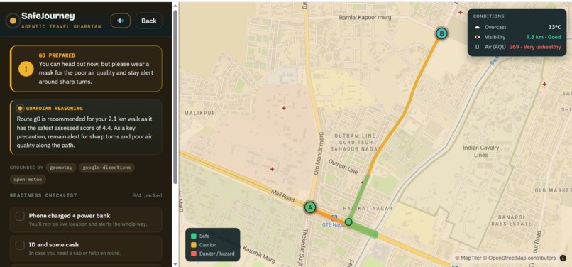
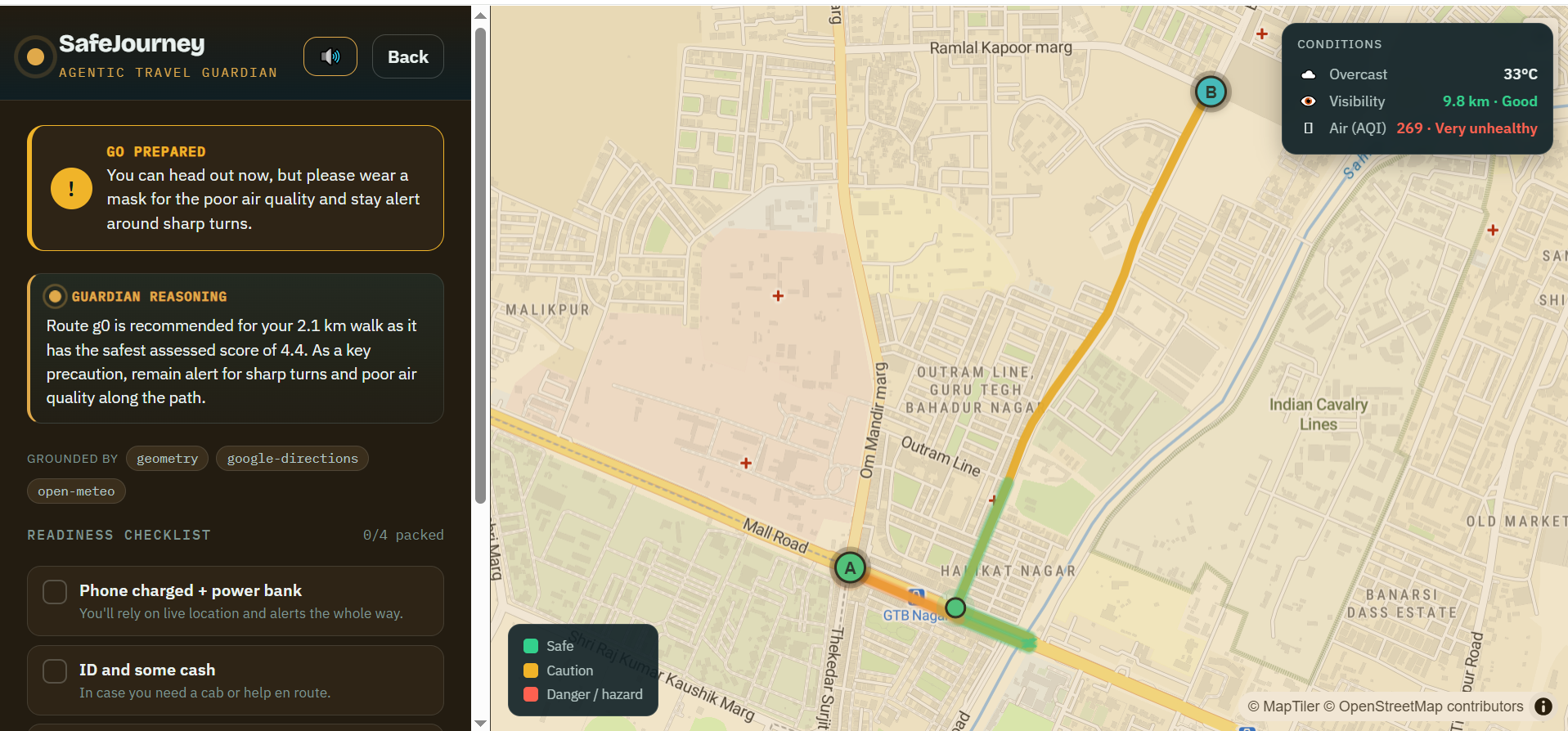
- Before you leave, it gives a pre-trip briefing grounded in live weather, visibility and air quality (AQI), a clear go / caution / wait verdict, and a readiness checklist that reacts to the conditions (fog lights for low visibility, an N95 for unhealthy air, a crosswind warning when it's gusty).
- When you plan a route, it scores every candidate on safety, not just speed, recommends the safest viable one, and shows why not the fastest — e.g. "+8 minutes to route around a recurring accident blackspot the fastest path runs straight through."
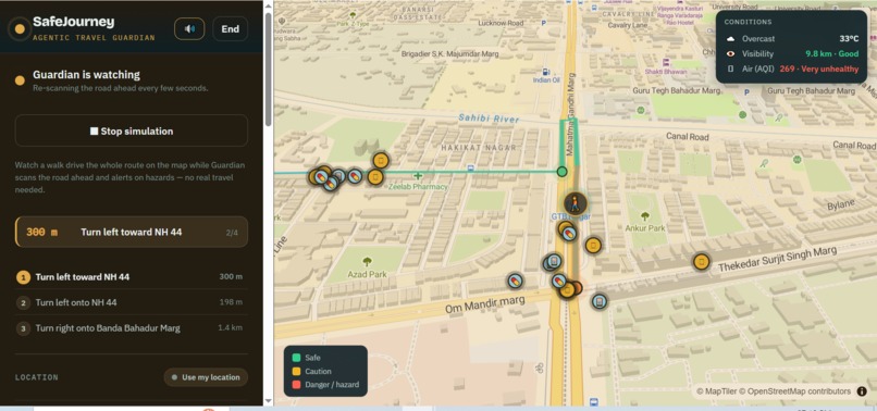
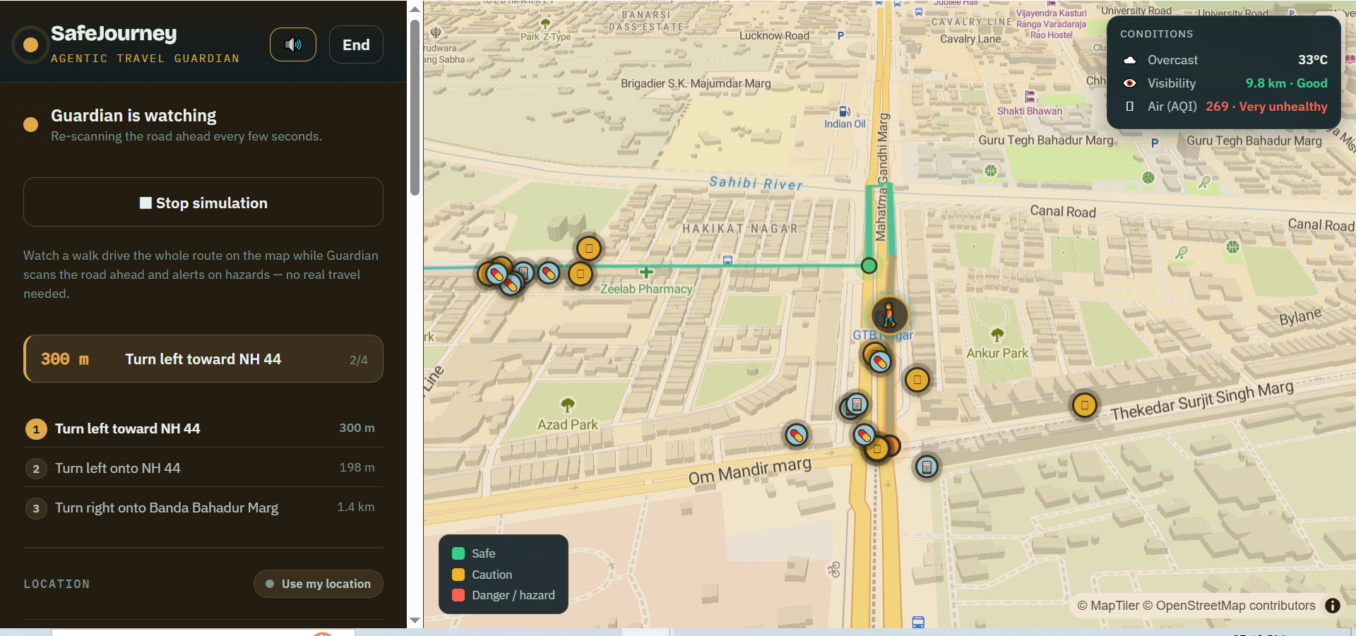
- While you travel, an autonomous background loop re-scans the road ahead on an interval it sets itself, detects what is newly dangerous, decides an action with Gemini, and pushes a live alert — reroute, safe harbour, or precise precautions — even with the app closed.
- On the road, it delivers turn-by-turn with spoken hazard narration, warns about hazards along your actual path, marks safe harbours and essentials (ATM / pharmacy / fuel / water) spread across the whole route, and answers a Guardian chat — "where can I get water or food nearby?" — with real places and distances from where you are right now.
- The entire interface tints to the live weather — storm indigo, smog amber, fog grey — so risk is something you feel, not something you have to read.
Everything is grounded in real data; the agents never invent a hazard.
How we built it
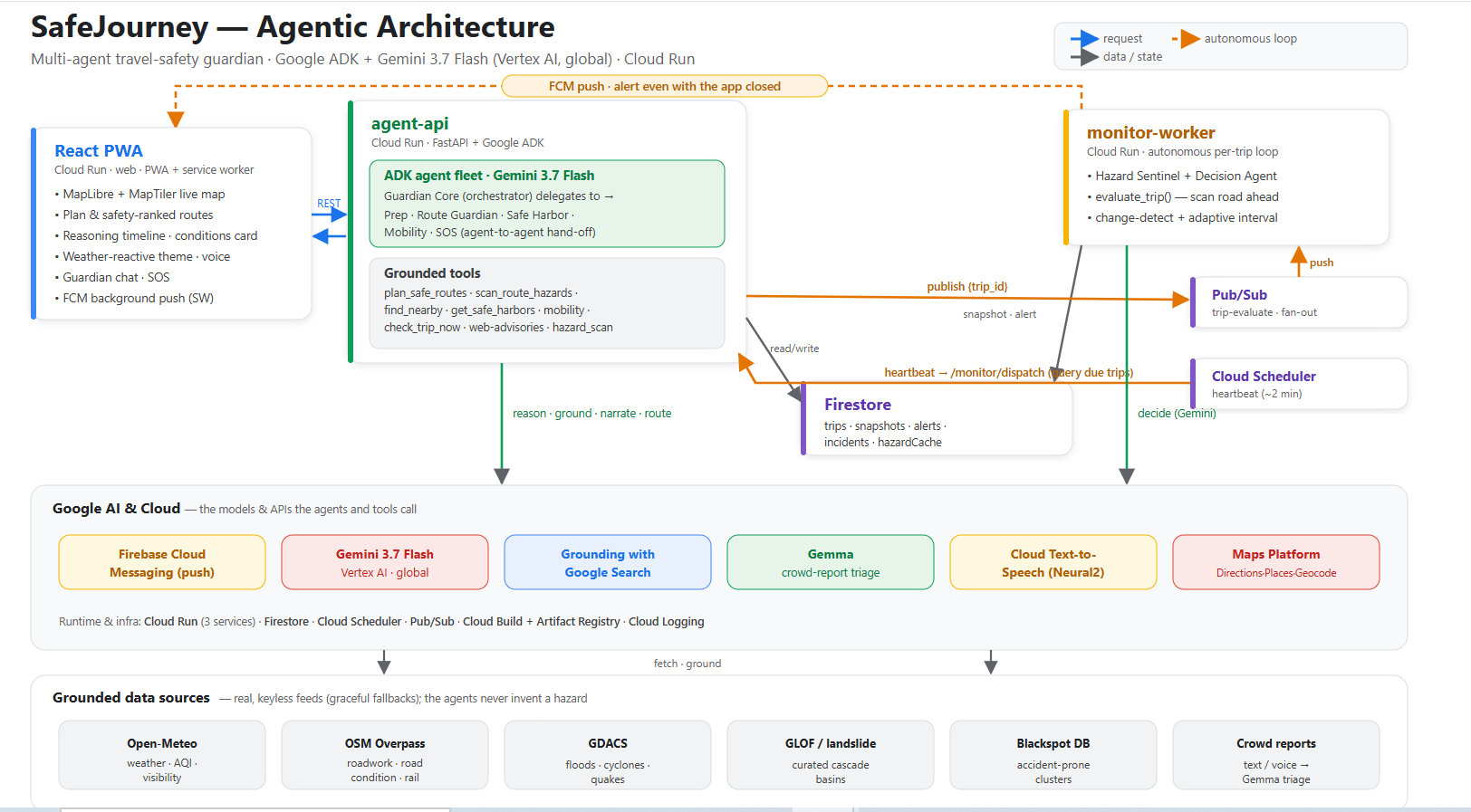
The system is a monorepo of three Cloud Run services plus a shared engine:
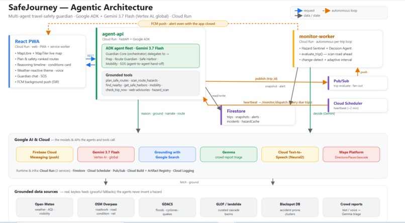
agent-api(FastAPI + Google ADK). A fleet of specialised agents — Guardian Core orchestrates Prep, Route Guardian, Safe Harbor, Mobility and SOS, delegating between them and calling grounded tools. Reasoning runs on Gemini 3.7 Flash via Vertex AI.monitor-worker(Cloud Run). The autonomous loop: Cloud Scheduler heartbeats the dispatcher, which queries Firestore for due active trips and fans each out over Pub/Sub; the worker runs a Hazard Sentinel corridor scan on the remaining path, change-detects new hazards, and a Decision Agent (Gemini) chooses an action that a deterministic rule engine validates. Alerts persist to Firestore and push via Firebase Cloud Messaging.packages/shared. A single Python engine — geohashing, theSafetyScoremodel, and typed hazard schemas — used identically by the API and the worker.web(React + Vite PWA). MapLibre + a MapTiler basemap, a live reasoning timeline, the conditions card, the weather-reactive theme, and voice via Google Cloud Text-to-Speech with an on-device browser-speech fallback.
Grounding comes from Gemini's Grounding with Google Search (live web advisories), Google Maps Platform (Directions, Places New, Geocoding), and keyless feeds (Open-Meteo weather/AQI, OpenStreetMap Overpass, GDACS). A second Google model, Gemma, handles the high-volume crowd-report triage — turning free-text or spoken hazard reports into the structured schema — so Gemini stays reserved for high-stakes reasoning.
Challenges we ran into
- Grounding real, local hazards. Broken roads, open manholes and sewage-flooded lanes aren't in any structured feed. We combined OpenStreetMap tags, an accident-blackspot DB, geometry (sharp turns / unlit stretches), crowd reports, and — crucially — Gemini Search grounding, which surfaced genuinely local, cited reports (Burari waterlogging, sewage over the carriageway) and snaps them onto the route so they warn you during the drive.
- Keeping the demo honest and offline-capable. Every external dependency degrades gracefully, so the exact same code runs offline (keyless weather, synthetic routes, rule-based decisions) and, with keys, on Google Cloud.
- Making a compressed drive feel real. Getting turn-by-turn narration, path-based proximity warnings, and the map marker to stay in sync during a ~1-minute simulated drive took several rewrites of the speech channel and the along-route projection math.
- Getting on Gemini 3.x. Vertex's regional endpoints 404 on every Gemini 3.x id, and the Developer-API free tier caps at ~20 requests/day. The unlock was Vertex on the
globallocation, which servesgemini-3.7-flashwith full quota — plus making our thinking-token handling model-aware (Gemini 3.x always "thinks", so a zero thinking budget is invalid and a tiny output budget starves the answer).
Accomplishments that we're proud of
- A genuinely autonomous, multi-agent system — it keeps working after you close the app, on a schedule it decides for itself, and you can watch the agents delegate in a live reasoning timeline.
- Safety over speed, with the trade-off made explicit — the fastest-vs-safest card is honest about the minutes it costs to avoid a blackspot.
- Local truth reaches the traveller — web-grounded waterlogging/roadwork/sewage in a specific neighbourhood actually warns you on the road, not just on a planning screen.
- Two Google models, each on the right job — Gemini for reasoning, Gemma for the triage firehose, plus Cloud TTS for hands-free, eyes-on-the-road guidance.
- It's deployed and demoable end to end on Google Cloud, with a deterministic hazard-injection hook for unedited live execution.
What we learned
- Grounding is the whole game. An agent is only as trustworthy as the data it acts on; pairing structured feeds with Search grounding — and letting a rule engine validate the model — is what makes an autonomous safety action safe to ship.
- Model access is a real engineering surface. The same model id behaves completely differently across Vertex regional vs
globalvs the Developer API (availability, quota, thinking semantics) — worth verifying empirically, not assuming. - Change-detection and adaptive scheduling are what turn "call an LLM in a loop" into an agent that's calm, cheap, and interrupts only when it matters.
- Accessibility is a feature, not a nicety — spoken narration and an at-a-glance weather-tinted UI matter most exactly when a rider can't look at a screen.
What's next for SafeJourney
- Real device GPS + live sharing with trusted contacts and one-tap 112, and richer SOS escalation.
- Broader hazard coverage — more OSM road-condition signals, official municipal feeds, and a growing crowd-report network so local knowledge compounds.
- On-device Gemma for offline triage and voice-in where connectivity is worst (the same places the hazards are).
- Personalisation — vehicle type, night vs day, and rider risk tolerance shaping both routing and how loudly the guardian speaks.
- Partnerships with delivery fleets and city transport authorities, where a per-route safety guardian scales to thousands of daily riders.
Log in or sign up for Devpost to join the conversation.