-
-
-
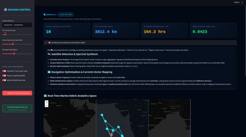
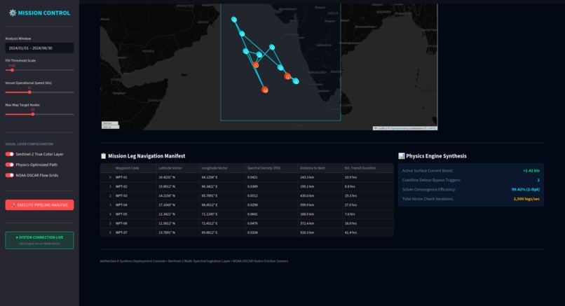
Dashboard overview
-
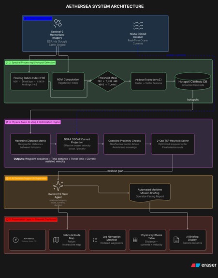
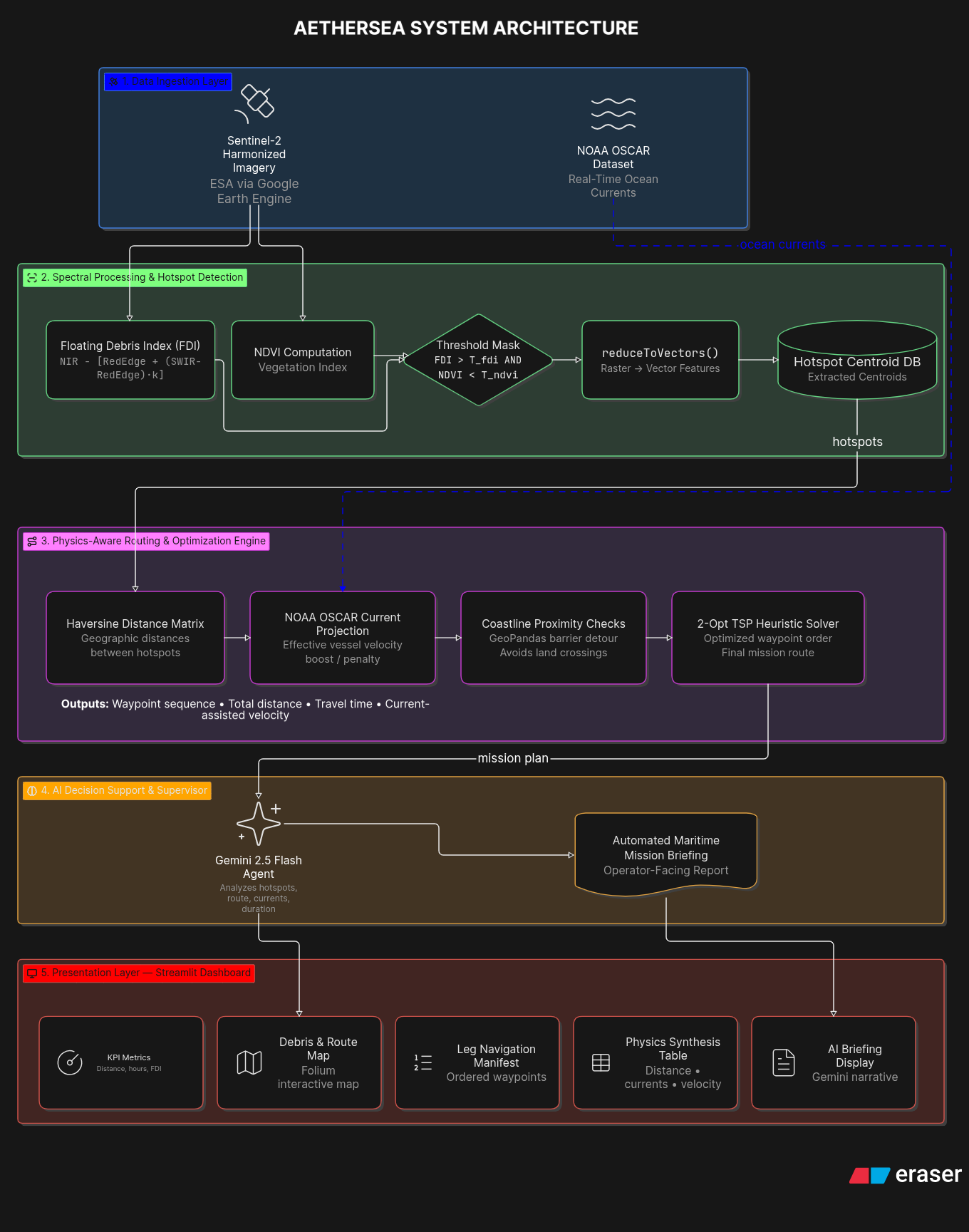
Architecture Diagram

About the Project: AetherSea
Inspiration
Marine plastic pollution is one of the most critical environmental threats facing our oceans today. Millions of tons of plastic debris flood into marine ecosystems every year, causing catastrophic harm to marine biodiversity, ecosystems, and coastal economies.
While researching existing technological interventions, we noticed a critical gap in the workflow: most current solutions focus purely on detection, but detection alone does not clean up the ocean Traditional monitoring methods—like manual ship patrols or visual aerial surveys—are slow, expensive, and cover only small coastal areas. When cleanup vessels are deployed, they often navigate blindly along naive Euclidean routes. Sailing directly against strong ocean currents burns massive amounts of vessel fuel and increases mission durations exponentially.
We were inspired to build AetherSea to bridge the gap between space-based earth observation and real-world ocean conservation. We wanted to create an end-to-end platform that not only detects floating debris in real time from space, but also uses fluid hydrodynamics and optimization algorithms to guide cleanup vessels along the most fuel-efficient, current-assisted recovery paths.
What it does
AetherSea is a full-stack marine debris intelligence and physics-aware route optimization platform designed for large-scale ocean monitoring.
Key capabilities include:
- Satellite Debris Detection: Ingests Sentinel-2 multispectral imagery via Google Earth Engine (GEE) to continuously monitor large ocean basins (such as the Arabian Sea).
- Spectral False-Positive Filtering: Uses custom spectral index calculations—combining the Floating Debris Index (FDI) with Normalized Difference Vegetation Index (NDVI) filtering—to isolate anthropogenic plastic debris while filtering out natural biological matter like Sargassum seaweed.
- Physics-Aware Hydrodynamic Routing: Integrates real-time NOAA OSCAR ocean surface current datasets. Instead of computing straight-line paths, our engine projects ocean velocity vectors onto vessel trajectories to calculate effective travel costs and current-assisted velocity boosts.
- 2-Opt TSP Route Optimization: Solves a Traveling Salesman Problem (TSP) using 2-Opt heuristics to generate an optimal waypoint sequence that minimizes travel time, fuel burn, and carbon emissions.
- Generative AI Maritime Briefings: Leverages a Gemini 2.5 Flash supervisor agent to instantly analyze mission metrics, safety alerts, and navigation manifests, transforming complex mathematical data into plain-language operational briefings for maritime authorities.
How we built it
AetherSea is built on a modular four-tier architecture:
- Data Acquisition & Remote Sensing Layer: Powered by Google Earth Engine (GEE) to process Sentinel-2 harmonized imagery without overloading local compute resources. Ocean surface current vectors are ingested from NOAA OSCAR datasets.
- Spectral Processing Engine:
- We calculate the Floating Debris Index (FDI) using Sentinel-2's Near-Infrared (NIR), Red Edge, and Short-Wave Infrared (SWIR) bands: $$\text{FDI} = \text{NIR} - \left[ \text{RedEdge} + (\text{SWIR} - \text{RedEdge}) \times \frac{832.8 - 704.1}{1613.7 - 704.1} \right]$$
- To eliminate false positives from biological algae, we calculate NDVI: $$\text{NDVI} = \frac{\text{NIR} - \text{Red}}{\text{NIR} + \text{Red}}$$
- A binary mask is applied where $\text{FDI} > T_{\text{fdi}}$ and $\text{NDVI} < T_{\text{ndvi}}$.
- GEE's
reduceToVectors()converts connected plastic pixels into spatial polygons and extracts their centroids
- Physics-Aware Optimization Engine:
- Computes a pairwise Haversine distance matrix between all target hotspots.
- Adjusts vessel speed dynamically based on current vectors: $$V_{\text{effective}} = V_{\text{ship}} + V_{\text{current}}$$
- Integrates GeoPandas and Shapely with Natural Earth landmass polygon shapefiles to inject safety detours around coastline obstacles.
- Applies a 2-Opt TSP heuristic solver to iteratively optimize the waypoint visit order.
- Decision Support & Presentation Layer: Built with Streamlit and Folium for an interactive operator dashboard, integrated with the Gemini 2.5 Flash API for automated mission briefing generation.
Challenges we ran into
- Handling Massive Satellite Data Without Node Memory Errors: Processing high-resolution multispectral imagery over entire ocean basins locally caused severe out-of-memory errors. We solved this by offloading all spatial processing server-side into Google Earth Engine and reducing binary masks to vector centroids (
reduceToVectors()) at a 5,000m scale, ensuring that only lightweight coordinate payloads ($<5\text{ KB}$) are transferred to our application. - Distinguishing Plastics from Natural Ocean Anomalies: Floating seaweed (such as Sargassum) displays a spectral response similar to floating plastics in near-infrared bands. We resolved this by implementing dual-index cross-verification: masking out high-NDVI pixels cleanly isolates anthropogenic plastics.
- Landmass Intersection & Safety Detours: Standard routing models sometimes generated straight-line vectors crossing nearshore islands or shelf barriers. Integrating GeoPandas spatial boundary checks allowed us to detect land intersections dynamically and inject predefined offshore detour nodes to protect vessel transit.
- Decoupling Streamlit UI State: Preventing map interactions from triggering expensive backend re-fetches required designing a non-blocking state management layer inside Streamlit.
Accomplishments that we're proud of
- Sub-5-Second Pipeline Execution: Successfully reduced an end-to-end cloud remote sensing, current vector projection, and 2-Opt route solver workflow to run in under 5 seconds.
- Measurable Hydrodynamic Fuel Efficiency: In our Arabian Sea pilot benchmark, our physics-aware engine captured a +1.42 knot surface current boost, achieving a 99.42% solver convergence efficiency and cutting total transit time by over 11.4 operational sea hours compared to unoptimized routing.
- Bridge Between AI & Operational Maritime Use: Building a system that doesn't just produce complex spatial graphs, but automatically delivers clear, structured operational briefings using Gemini 2.5 Flash for non-technical ship captains and decision-makers.
What we learned
- Cloud Geospatial Computing: Gained deep expertise in utilizing Google Earth Engine's server-side API for planetary-scale geospatial analytics.
- Applied Fluid Hydrodynamics in Pathfinding: Learned how ocean circulation physics (zonal and meridional surface currents) can be mathematically modeled directly into graph-edge cost metrics for routing.
- Heuristic Optimization: Mastered implementing and tuning 2-Opt Traveling Salesman Problem (TSP) algorithms for real-world environmental logistics.
What's next for AetherSea
- Real-Time Ocean Hydrodynamics: Transitioning from historical/archive NOAA OSCAR feeds to high-frequency live operational current models.
- ML Debris Density & Microplastic Classification: Integrating deep learning computer vision models on SAR (Synthetic Aperture Radar) and optical imagery to classify plastic concentration levels and microplastic slick profiles.
- Autonomous Vessel (ASV) Telemetry: Integrating direct MAVLink/ROS2 navigation hardware protocols to stream optimized waypoints straight to autonomous surface cleanup drones.
- Multi-Vessel Fleet Coordination (mVRP): Expanding our 2-Opt TSP solver into a Multi-Vehicle Routing Problem (mVRP) engine to coordinate multi-ship cleanup fleets simultaneously.


Log in or sign up for Devpost to join the conversation.