-
The Forshadowing Map
-
Sources
-
Data
-
Genomic Tree
-
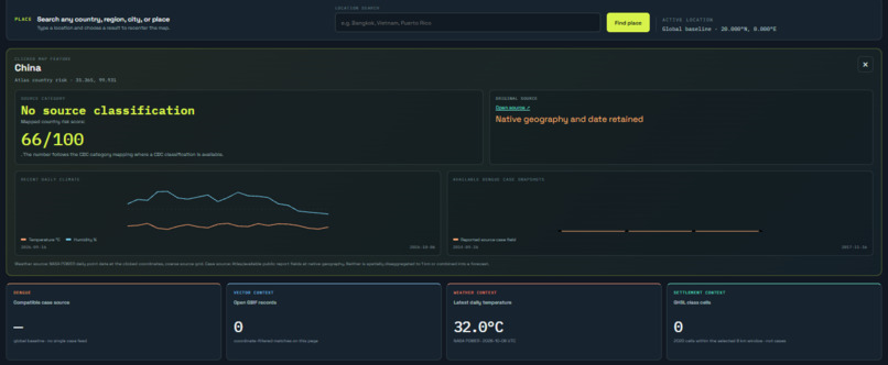
Prediction of chance of dengue outbreak
Inspiration
Coming from Sri Lanka, India, Myanmar, and the U.S., our team has personally witnessed the devastating impacts of dengue outbreaks in South and Southeast Asia. Over 400 million people are infected annually, and nearly 75% of the global burden falls on Asia. We noticed a major flaw in existing early-warning tools: they focus almost exclusively on weather factors like rainfall and temperature to predict mosquito population surges. However, weather data alone fails to predict clinical severity. When a population with prior immunity to one dengue strain is exposed to a new dominant serotype (e.g., DENV-2), severe dengue and hospitalizations surge. We were inspired to build a solution that addresses both WHERE mosquitoes breed and WHEN severe outbreaks will occur by combining environmental intelligence with genomic surveillance.
What it does
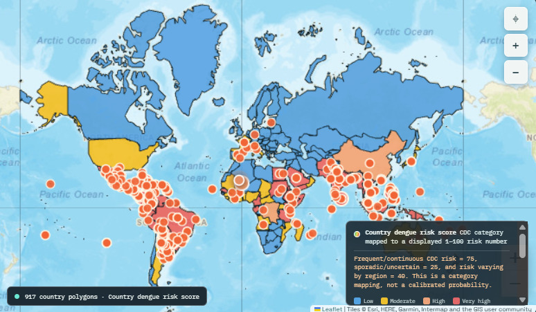
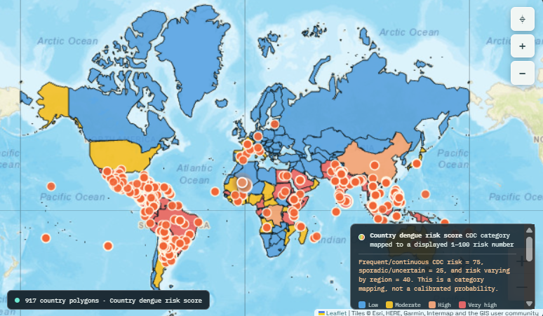
Aegis DENV is an integrated dengue early-warning system and interactive web platform designed to forecast transmission hotspots and clinical severity before cases surge. Instead of treating climate and viral data separately, Aegis DENV blends:
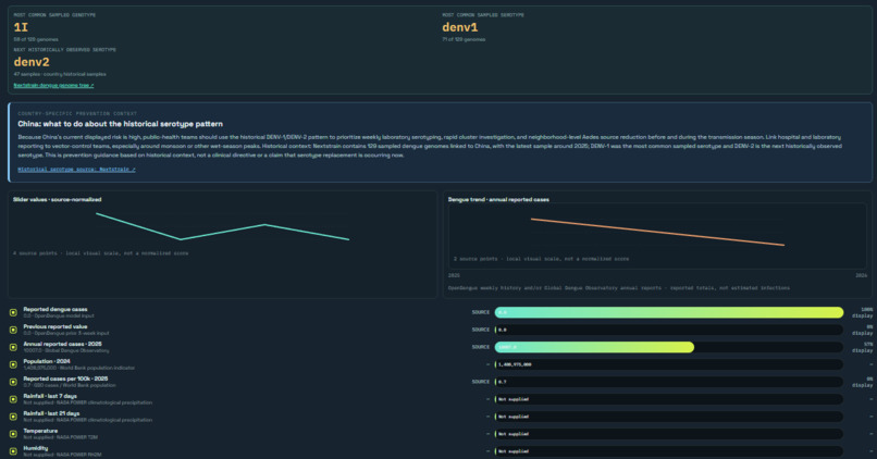
Environmental Data: Real-time satellite metrics (temperature, rainfall lag periods, humidity, surface water, vegetation, and urban density) to pinpoint ideal mosquito breeding grounds.
Epidemiological & Vector Data: Reported dengue cases and Aedes mosquito occurrence records.
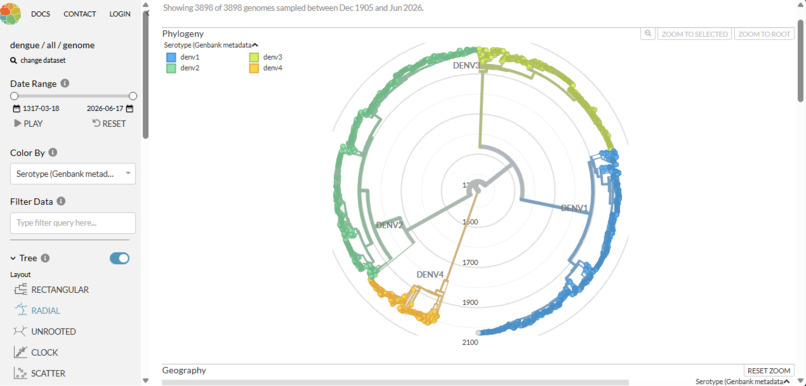
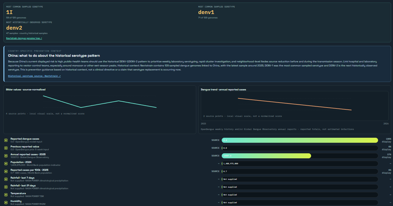
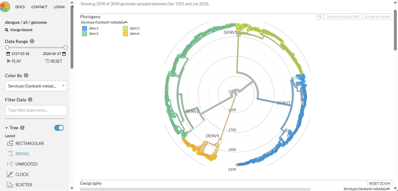
Genomic Surveillance Data: Circulating viral serotypes (DENV-1 through DENV-4) and lineage tracking.
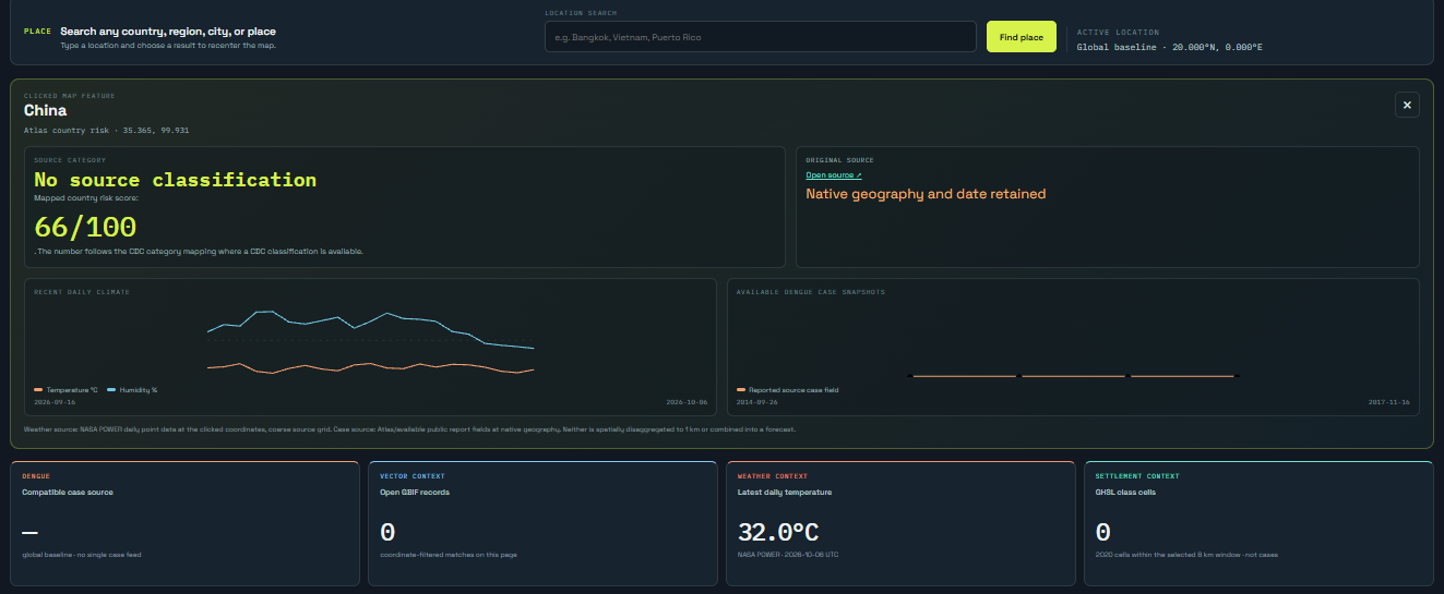
The platform processes these multi-source inputs into localized dengue risk scores, giving public health authorities crucial lead time to target vector control, conduct breeding site inspections, and prepare hospital ICUs before severe outbreaks peak.
How we built it
We structured Aegis DENV around open-access global datasets and a unified web interface:
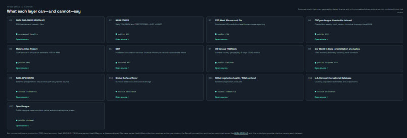
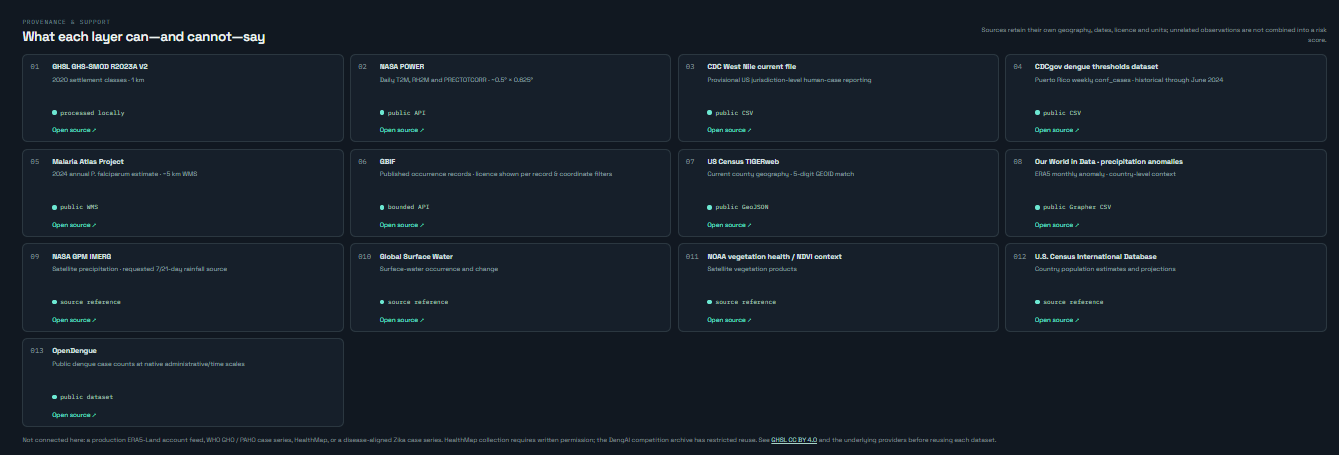
Environmental & Spatial Processing: Ingested rainfall data (NASA GPM IMERG across 7, 14, 21, and 28-day lags), climate variables (Copernicus ERA5 Land), satellite imagery (Copernicus Sentinel-2), human settlement density (GHSL), and population metrics (WorldPop).
Biological & Epidemiological Integration: Standardized case tracking using WHO Global Dengue Surveillance, species mapping using GBIF, and viral lineage/serotype data using NCBI Virus and GenBank.
Platform & Modeling Pipeline: Designed a web prototype interface to visualize risk layers, display contributing risk factors, and map regional trends across South and Southeast Asia.
Challenges we ran into
Uneven Genomic Surveillance: Genomic sequencing is heavily concentrated in major urban centers and well-equipped facilities, creating geographic sampling bias in rural areas.
Heterogeneous Data Aggregation: Combining vast satellite imagery, discrete temporal lag periods (7–28 days), localized case reports, and genomic sequence metadata into a synchronized geographic format posed significant alignment challenges.
Confounding Environmental Indicators: Distinguishing between correlation and causation—since factors like human behavior, water storage habits, and local mosquito control efforts strongly influence actual transmission alongside climate drivers.
Accomplishments that we're proud of
Successfully conceptualized a multi-layered predictive architecture that bridges the critical gap between mosquito vector density and viral clinical severity.
Developed a functional web prototype capable of presenting complex environmental and genomic data through a intuitive interface.
Assembled an international collaboration across Sri Lanka, India, Myanmar, and the U.S., bringing personal lived experience and regional expertise directly into the project's design.
What we learned
Multifactorial Risk Mechanics: Dengue outbreaks are never driven by rainfall alone; they depend on intricate interactions between temperature-dependent replication rates, local population immunity, urban infrastructure, and shifting viral serotypes.
Surveillance Timelines: Case-based reporting is inherently reactive. Integrating satellite climate lags with genomic lineage shifts provides public health teams with actionable lead time before hospital admissions spike.
Scalability of Open Data: Leveraging globally available satellite and genomic databases allows localized public health models to scale across endemic regions without requiring brand-new infrastructure.
What's next for Aegis DENV
Model Calibration & Lag Testing: Train and refine predictive algorithms across historical 7, 14, 21, and 28-day environmental window variations against confirmed historical outbreaks.
Automated Data Pipelines: Connect live data streams from NASA, Copernicus, and NCBI to dynamically update risk indices on the website.
Regional Expansion & Validation: Expand calibration beyond South and Southeast Asia into other dengue-endemic regions across Latin America and Sub-Saharan Africa.
Public Health Integration: Partner with local vector-control agencies and healthcare decision-makers to test how early alerts perform in supporting targeted interventions.
Research
Team Name: Mosquito Hunters Team Members: Stella, Thehas and Ritisha
Research Question and Problem Can the integration of real-time environmental, epidemiological and dengue genomic data improve the early detection and prediction of dengue hotspots across South and Southeast Asia? Dengue is widely acclaimed as the most substantial arthropod-borne viral disease in public health. According to WHO, it is geographically distributed across more than 100 countries in both tropical and sub-tropical climates (Guha-Sapir & Schimmer, 2005). Every year, there are over 400 million cases of dengue fever worldwide, and 22,000 fatalities. In tropical nations in Asia and South America, the rainy season offers the best conditions for the spread of dengue disease. Humans are usually infected by female Aedes mosquitoes carrying the dengue virus. Dengue fever cannot be spread by humans, but it can be transferred through blood transfusions from an infected to a healthy, uninfected individual (Pourzangiabadi et al., 2024). There are four distinct serotypes for dengue: DENV-1, DENV-2, DENV-3 and DENV-4. When a DENV-2 is reported to be the principal serotype associated with severe dengue and adverse outcomes in regions such as in India (Dinkar & Singh, 2026). When a population previously exposed to one Dengue serotype (e.g., DENV-1) is exposed to a new dominant serotype (e.g., DENV-2), the rate of Severe Dengue (Dengue Hemorrhagic Fever) skyrockets. However, there has been a limited number of tools on detecting the viral mutations of different regions and forecasting these severe dengue outbreaks. Current predictive models also rely purely on environmental data (like rainfall and temperature), which can predict where mosquito populations will grow, but fail to predict the clinical severity of the disease. Our project aims to address both WHERE and WHEN dengue hotspots are most likely to occur using a combination of both environmental and genomic engines. As our team consists of people from Sri Lanka, India, Myanmar and the U.S., we have witnessed the rapid transmission of the disease and we aim to minimize fatalities with the help of our project.
Background, Context and Significance Dengue is a major mosquito-borne viral disease caused by dengue virus (DENV) and transmitted primarily by Aedes aegypti and Aedes albopictus. Transmission is strongly influenced by environmental and socioeconomic conditions. Temperature affects mosquito development, survival and viral replication, while rainfall and humidity influence breeding habitats. Studies have found associations between these climatic factors and dengue incidence, although effects vary geographically (Li et al., 2020; Soo et al., 2023). South and Southeast Asia are particularly vulnerable due to tropical climates, monsoon rainfall, dense populations, rapid urbanization and inadequate drainage and waste management. In 2024, WHO reported 14.6 million dengue cases and 11,201 deaths globally, with around 75% of the burden occurring in Asia (World Health Organization, 2025a). The region also contains large populations at risk, with approximately 1.3 billion people living in dengue-risk areas in the WHO South-East Asia Region (World Health Organization, 2025b). Dengue has four serotypes—DENV-1 to DENV-4—and infection with one does not provide complete protection against the others. Secondary infection with a different serotype can increase the risk of severe disease, while viral and host factors also influence severity (Simmons et al., 2014; Rao et al., 2016). Therefore, identifying circulating serotypes and viral lineages provides information beyond case numbers alone. A key surveillance challenge is that case-based systems may detect outbreaks only after transmission has increased. Environmental data can indicate favorable conditions for mosquito transmission, while genomic data can reveal circulating viruses. Integrating environmental, epidemiological and genomic data could therefore enable earlier identification of emerging dengue hotspots and provide a more comprehensive assessment of transmission risk, particularly in South and Southeast Asia.
Proposed Solution Our proposed solution is a dengue early-warning system that brings together environmental, epidemiological and genomic data. The main idea is to look for changes in dengue risk before a large increase in cases is reported. We would first use environmental data such as temperature, rainfall, humidity, surface water, vegetation, urbanization and population density to identify areas where conditions are becoming more suitable for Aedes mosquitoes. We would compare these changes with historical dengue cases to determine whether certain environmental patterns consistently occur before increases in transmission, and how much earlier they can be detected. We would then add dengue case data to show where transmission is actually increasing, along with publicly available genomic data to determine which serotypes and viral lineages are circulating in those areas. This would allow us to look at the environment and the virus together rather than treating them as separate parts of the problem.The different datasets would be combined into a model that produces a dengue risk estimate for different locations and time periods. We would test whether this combined approach can identify future dengue hotspots earlier and more accurately than using environmental or epidemiological data alone. The goal is to provide an additional early-warning tool that could give health authorities more time to increase mosquito surveillance, prepare healthcare services and investigate emerging outbreaks. While our initial focus would be South and Southeast Asia, the use of globally available datasets would allow the approach to be tested in other dengue-endemic regions as well.
Data & methodology WHO Global Dengue Surveillance provides dengue cases by location and time, serving as the main outcome data. NASA GPM IMERG provides global rainfall data used to calculate rainfall over 7, 14, 21 and 28 day periods. Copernicus ERA5 Land provides temperature, humidity, soil moisture and other environmental variables related to mosquito transmission. Copernicus Sentinel 2 provides satellite imagery used to measure vegetation, surface water and other environmental conditions. WorldPop provides population data used to estimate the number of people exposed to dengue risk. GHSL provides built up and urbanization data to represent urban environments suitable for Aedes mosquitoes. Global Surface Water provides surface water data to identify areas where water may persist. GBIF provides georeferenced records showing where Aedes aegypti and Aedes albopictus have been recorded. NCBI Virus and GenBank provide dengue genomic sequences used to identify circulating serotypes and viral lineages.
Prototype Plan and Future Goals The main potential impact of this project is earlier detection of areas at increasing risk of dengue transmission. By combining environmental conditions, dengue surveillance, population and urbanization data, mosquito distribution and viral genomic information, the system could provide a more complete picture of where outbreaks may emerge. In practice, the system could support public-health authorities in prioritizing mosquito-control measures, strengthening surveillance, preparing healthcare facilities and allocating resources to areas at higher risk. It could also help researchers identify relationships between climate, environmental change and the movement of dengue virus lineages. The prototype is designed to be scalable because it relies largely on globally available datasets. Although our initial focus is South and Southeast Asia, the same framework could be adapted to other dengue-endemic regions. With further validation and integration of real-time data, the system could develop from a research prototype into an early-warning platform for dengue prevention and outbreak preparedness.
Impact, implications & application One of the main implications of this project is that dengue surveillance could move beyond simply waiting for reported cases to increase. By combining dengue surveillance with environmental conditions, mosquito distribution, population density and genomic data, the system could identify patterns associated with rising transmission risk earlier. This also recognizes that dengue risk is multifactorial. Rainfall alone does not determine outbreaks, but interacts with temperature, humidity, mosquito habitats, population exposure and existing viral circulation. The greatest potential impact is providing public health authorities with additional time to respond. Earlier risk signals could support targeted mosquito surveillance, breeding site inspections, vector control and hospital preparation, particularly in densely populated areas of South and Southeast Asia. The integrated dataset could also help researchers investigate relationships between environmental conditions, viral lineages and outbreak patterns. Our prototype website is designed to present these datasets through a single interface. Future versions could incorporate regularly updated data and display current risk levels, contributing factors, historical trends and comparisons between locations. The system could ultimately be expanded across South and Southeast Asia and adapted to other dengue endemic regions. The goal is not to replace existing surveillance, but to provide an additional layer of information that can help identify where action may be needed earlier.
Feasibility & execution plan The project is feasible because most of the required data are already publicly available from WHO, NASA, Copernicus, WorldPop, GHSL, GBIF and NCBI. These datasets can be combined into a common geographic and time based format instead of being collected ourselves. We have also developed a working website prototype, giving us a foundation for the final system. The next step is to connect the data sources and match historical dengue cases with rainfall, temperature, humidity, surface water,vegetation, population and urbanization data. We will test time periods of 7, 14, 21 and 28 days to identify which environmental changes are most closely followed by increases in dengue cases. These variables will then be used to train and test the prediction model, with genomic data added to identify circulating serotypes and viral lineages. We will compare the combined model with simpler models to see whether the additional data improve predictions. After testing the model on historical data, the system can be connected to regularly updated data and used to display current risk estimates and the factors affecting them. It will then be tested across several dengue endemic regions to assess how well it works in different areas. Since the prototype, datasets and basic structure are already in place, the main work remaining is connecting the data, developing the model, testing it and integrating the results into the website.
Limitations Genomic surveillance is uneven because sequencing is often concentrated in major cities and well equipped healthcare facilities, leaving rural and under resourced areas underrepresented. This can bias estimates of circulating serotypes and viral lineages. Dengue case data also depend on healthcare access, testing and reporting, so increases may sometimes reflect better detection rather than increased transmission. Environmental datasets have wider coverage but may not capture conditions at neighbourhood or breeding site level. Rainfall, vegetation and surface water are indirect indicators, while transmission is also affected by mosquito control, water storage, immunity, human behaviour and population movement. These factors are difficult to capture consistently.Environmental relationships with dengue may vary between regions, so the model would require regional calibration. Correlation should not be treated as causation, and differences in data availability may limit real time prediction. Predictions will also contain uncertainty, with false positives potentially wasting resources and false negatives delaying responses. The system should therefore support, rather than replace, existing surveillance and require validation across different countries and outbreak periods before deployment.
Citations Guha-Sapir, D., & Schimmer, B. (2005). Dengue fever: new paradigms for a changing epidemiology. Emerging Themes in Epidemiology, 2(1), 1. URL: https://doi.org/10.1186/1742-7622-2-1 Pourzangiabadi, M., Najafi, H., Fallah, A., Goudarzi, A., & Pouladi, I. (2025). Dengue virus: Etiology, epidemiology, pathobiology, and developments in diagnosis and control – A comprehensive review. Infection, Genetics and Evolution, 127, 105710. URL: https://doi.org/10.1016/j.meegid.2024.105710 Dinkar, A., & Singh, J. (2026). Dengue serotypes and their severity correlation: A hospital-based observational study. Enfermedades Infecciosas y Microbiología Clínica (English Edition), 44(2), 503074. URL: https://doi.org/10.1016/j.eimce.2026.503074 Lee, C. K., et al. (2020). Association between dengue viremia kinetics and dengue severity: a systematic review and meta-analysis. PLoS Neglected Tropical Diseases. URL: https://pubmed.ncbi.nlm.nih.gov/32856357/ Li, Y., Dou, Q., Lu, Y., Xiang, H., Yu, X., & Liu, S. (2020). Effects of ambient temperature and precipitation on the risk of dengue fever: a systematic review and updated meta-analysis. Environmental Research, 191, 110043. URL: https://pubmed.ncbi.nlm.nih.gov/32810500/ Rao, C., et al. (2016). Meta-Analysis of Dengue Severity during Infection by Different Dengue Virus Serotypes in Primary and Secondary Infections. PLoS ONE, 11(5), e0154760. URL: https://pubmed.ncbi.nlm.nih.gov/27213782/ Simmons, C. P., et al. (2014). The relationship between secondary dengue infection and severe disease: a systematic review and mathematical modelling study. URL: https://pubmed.ncbi.nlm.nih.gov/25253207/ Soo, K. M., et al. (2023). The association between dengue case and climate: a systematic review and meta-analysis. Journal of Infection and Public Health. URL: https://pubmed.ncbi.nlm.nih.gov/36561711/ World Health Organization. (2025a). Dengue: global situation, surveillance and progress – 2024 update. URL: https://www.who.int/westernpacific/publications/i/item/who-wer10052-665-678 World Health Organization. (2025b). Dengue and severe dengue — South-East Asia Region. URL: https://www.who.int/southeastasia/health-topics/dengue-and-severe-dengue World Health Organization Indonesia. (2024). Indonesia takes decisive, pioneering action to strengthen multisource collaborative surveillance for dengue. URL: https://www.who.int/indonesia/news-room/item/30-07-2024-indonesia-takes-decisive--pioneering-action-to-strengthen-multisource-collaborative-surveillance-for-dengue World Health Organization South-East Asia Regional Office. (2026). From sequencing to surveillance: WHO SEARO and CSIR-IGIB host regional workshop on dengue genomics. URL: https://www.who.int/southeastasia/news/detail/17-04-2026-searo-sir-igib-dengue-genomics World Health Organization. (2026). Dengue Global Update: data as of end of June 2026. Weekly Epidemiological Record, 101(29). URL: https://www.who.int/publications/journals/weekly-epidemiological-record/WER101-29 NASA Global Precipitation Measurement Mission. (n.d.). Integrated Multi-satellitE Retrievals for GPM (IMERG). URL: https://gpm.nasa.gov/data/imerg Copernicus Climate Change Service. (n.d.). ERA5-Land hourly data from 1950 to present. URL: https://cds.climate.copernicus.eu/datasets/reanalysis-era5-land-timeseries European Space Agency, & Copernicus. (n.d.). Sentinel-2 satellite data. URL: https://dataspace.copernicus.eu/data-collections/copernicus-sentinel-missions/sentinel-2 WorldPop. (n.d.). Global high-resolution population datasets. URL: https://hub.worldpop.org/project/categories?id=3 European Commission Joint Research Centre. (n.d.). Global Human Settlement Layer (GHSL). URL: https://human-settlement.emergency.copernicus.eu/downloadWizard.php European Commission Joint Research Centre. (n.d.). Global Surface Water Explorer. URL: https://global-surface-water.appspot.com/ Global Biodiversity Information Facility. (n.d.). Occurrence records for Aedes aegypti and Aedes albopictus. URL: https://www.gbif.org/occurrence/search National Center for Biotechnology Information. (n.d.). NCBI Virus Variation: Dengue virus. URL: https://www.ncbi.nlm.nih.gov/labs/virus/ National Center for Biotechnology Information. (n.d.). GenBank. URL: https://www.ncbi.nlm.nih.gov/genbank/


Log in or sign up for Devpost to join the conversation.