- Have you ever been on the side of the road with a flat tire only to realize that you don’t have a jack or a spare tire?
- Or perhaps, you had a car accident and was too panicked to realize where your actual position was on a particular road?
- Do you look at mile markers, street signs, or know what direction that you are traveling in on every road that you embark on?
First responders, such as fire, ambulance, and law enforcement personnel, mobile repair facilities that assist you with tire changes, and towing service personnel that tow your vehicle where you need it also suffer from your tragedy. According to RapidSOS’ Outcomes: Quantifying the Impact of Emergency Response Times, researchers found that inaccurate location is, “the most important challenge for the existing 9-1-1 infrastructure” (RapidSOS 3). They also state that the “inability to determine a user’s precise location in an emergency often causes calls to be routed to the wrong 9-1-1 dispatch center, wasting valuable time asking a caller to describe their location before help can be sent” (RapidSOS 3). Each one of these assistance personnel have literally found themselves on the wrong side of the road, heading in the wrong direction, or just completely lost due to inaccuracies in information given by callers. It reduces response times, contributes to negative feelings from victims of tragedies, and increases costs through wasted fuel, wasted time, and wear and tear on equipment used during responses.
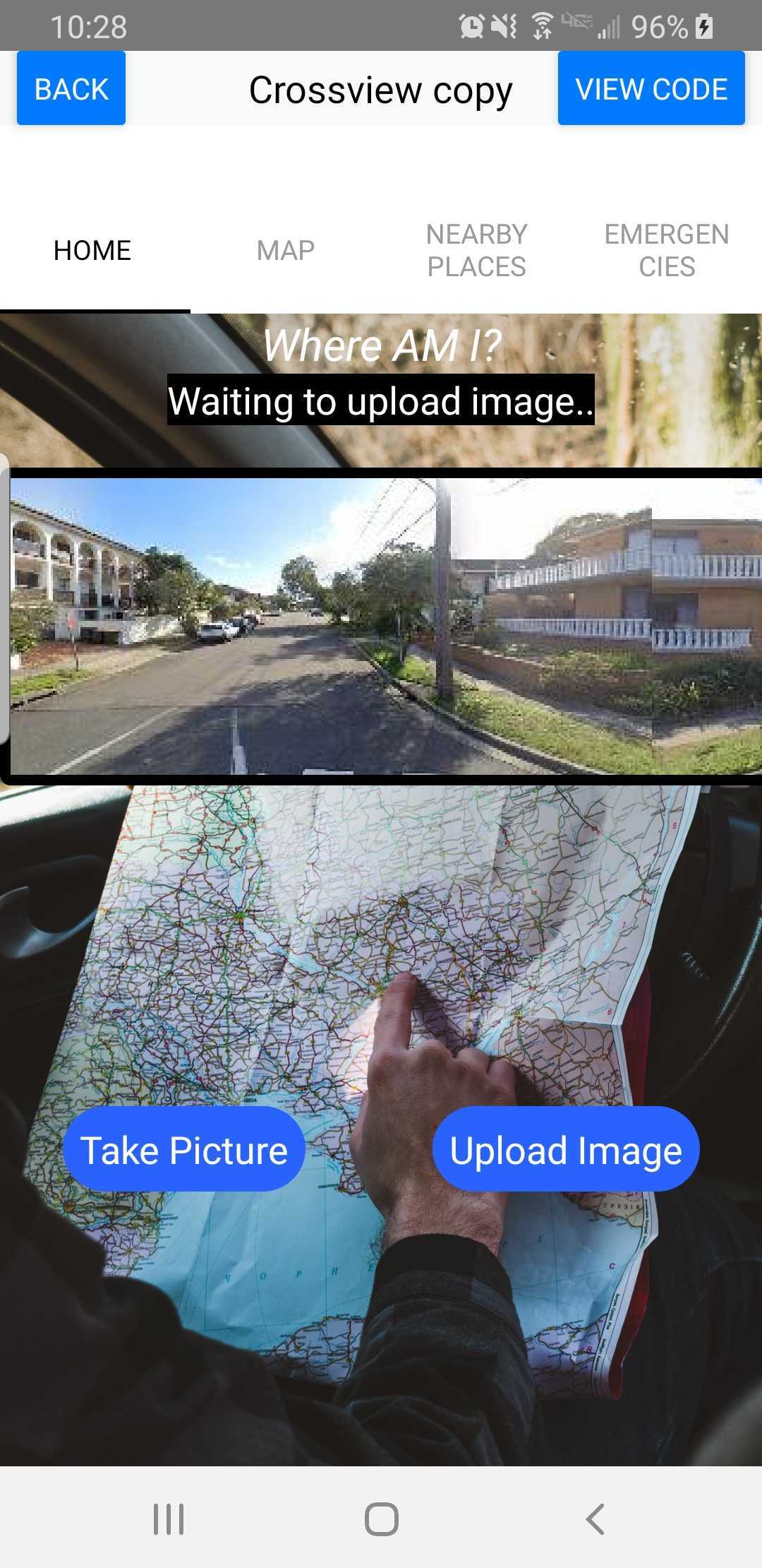
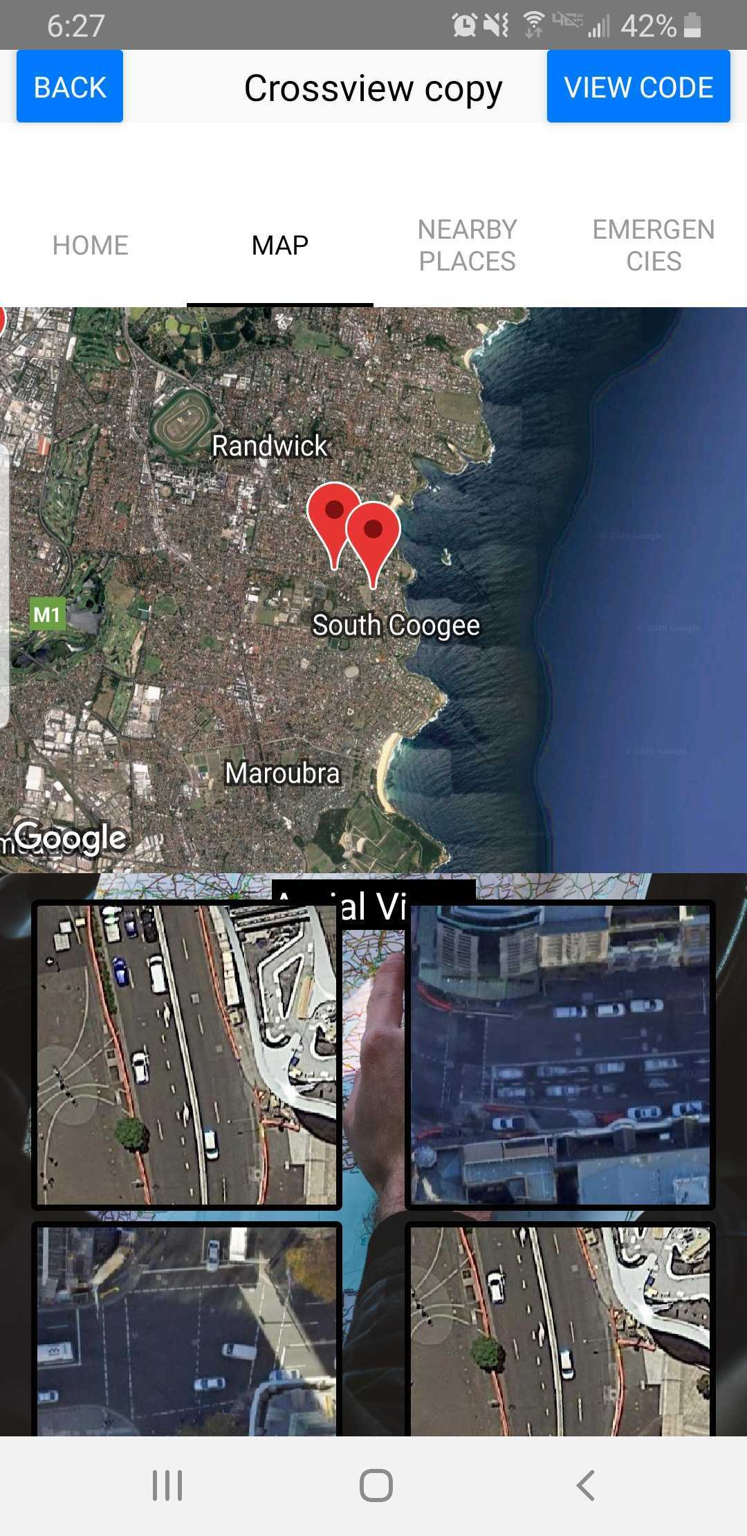
Where Am I? Automated Mapping is an adequate solution to these problems. Since the majority of phone calls for assistance comes from mobile phones, determining a location can be somewhat difficult, especially if the caller doesn’t even know where they’re at. Since most mobile phones utilize a built-in camera, Where Am I? can use a single photo and/or multiple photos, if need be, from a mobile device to narrow down possibilities for responders, thus eliminating the hassle involved with location information gathering from callers. Response times, negative feelings towards responders and their respective companies, and increased costs should improve.
Challenges include:
- influencing mobile phone users to download app, before an emergency situation or inconvenience arises, and
- nighttime can cause problems with taking adequate photos that the machine learning algorithm can process
Possible solutions to these problems are:
- developing partnerships with responders to increase people’s exposure to this available service. Hospitals, law enforcement centers, mobile repair facilities, and towing companies can be contacted to promote the service. Print and online advertisements can be utilized as well.
- implementing a method to test the viability of photos
Sources: RapidSOS, Outcomes Quantifying the Impact of Emergency Response Times, cdn2.hubspot.net/hubfs/549701/Documents/RapidSOS_Outcomes_White_Paper_-_2015_4.pdf. Accessed 24 Oct. 2020.
Inspiration
During difficult situations, first responders, repair technicians, and tow truck drivers come to our aide. A lot of times they perform services for people without complaint and oftentimes, at a sacrifice to themselves. Finding ways to make these heroes' jobs a little easier can go a long ways in showing the appreciation that they deserve. Combine this effort with GPS technological advances and machine learning and you have Where Am I? Automated Mapping.
What it does
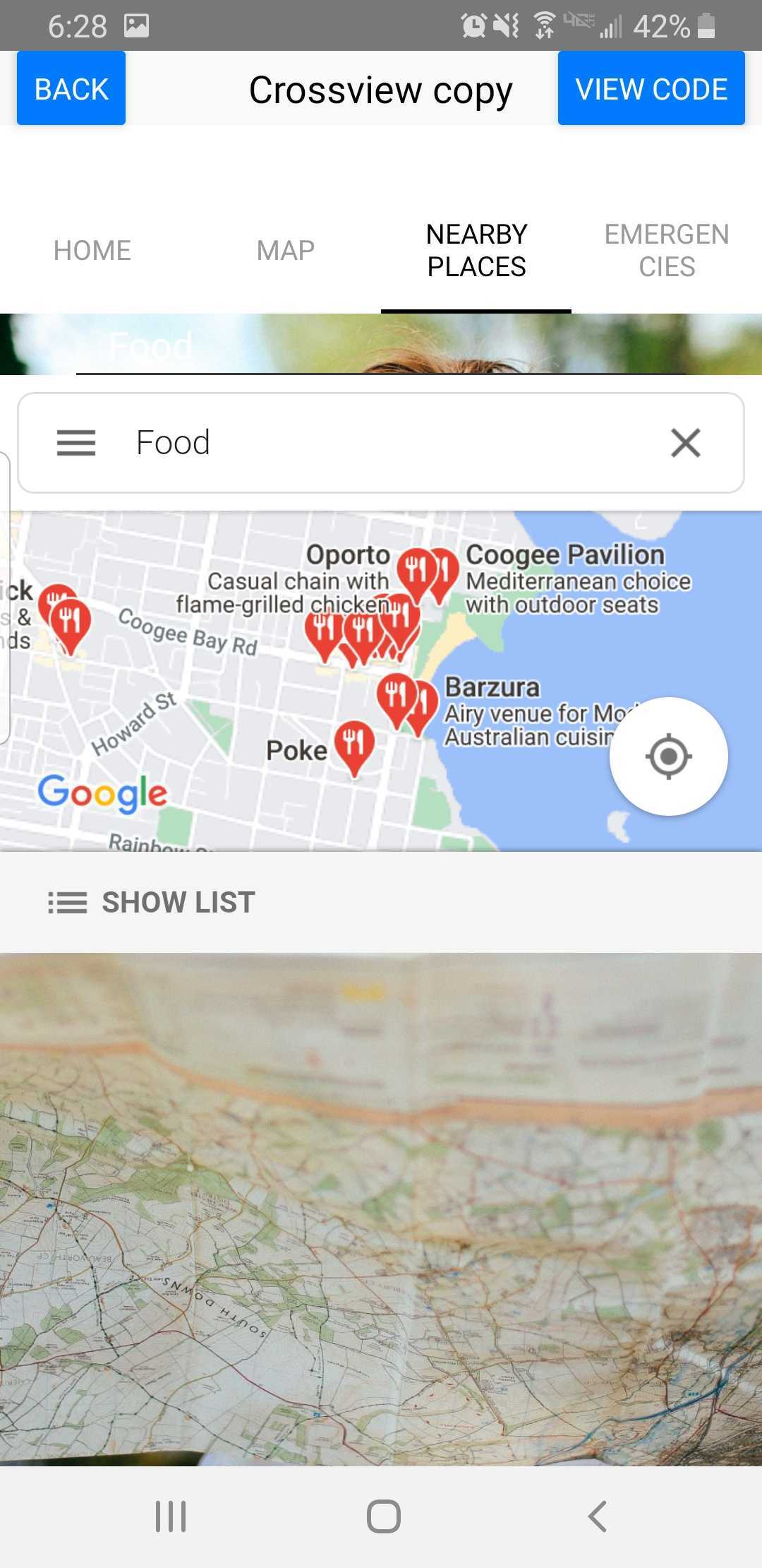
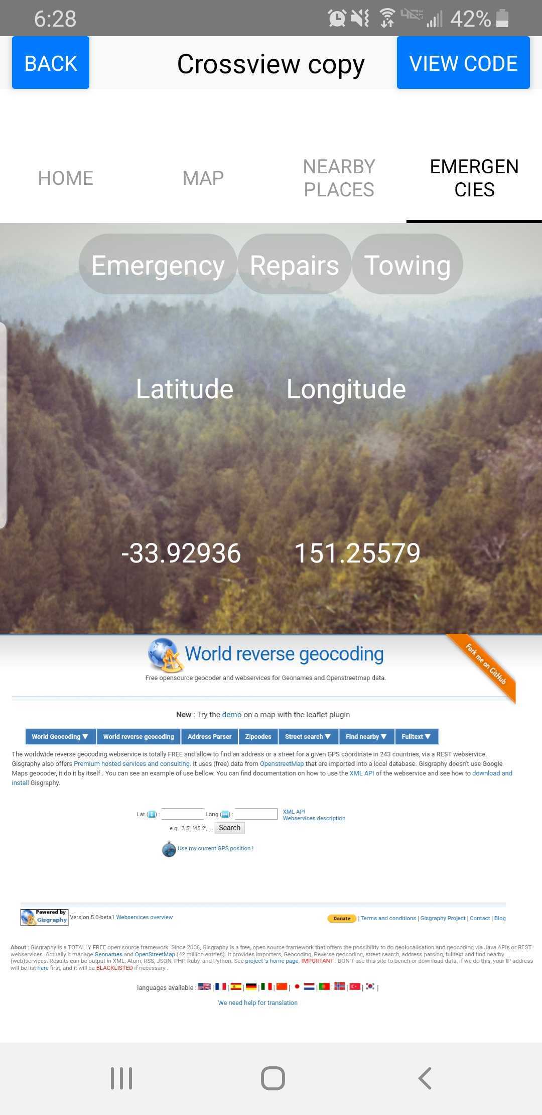
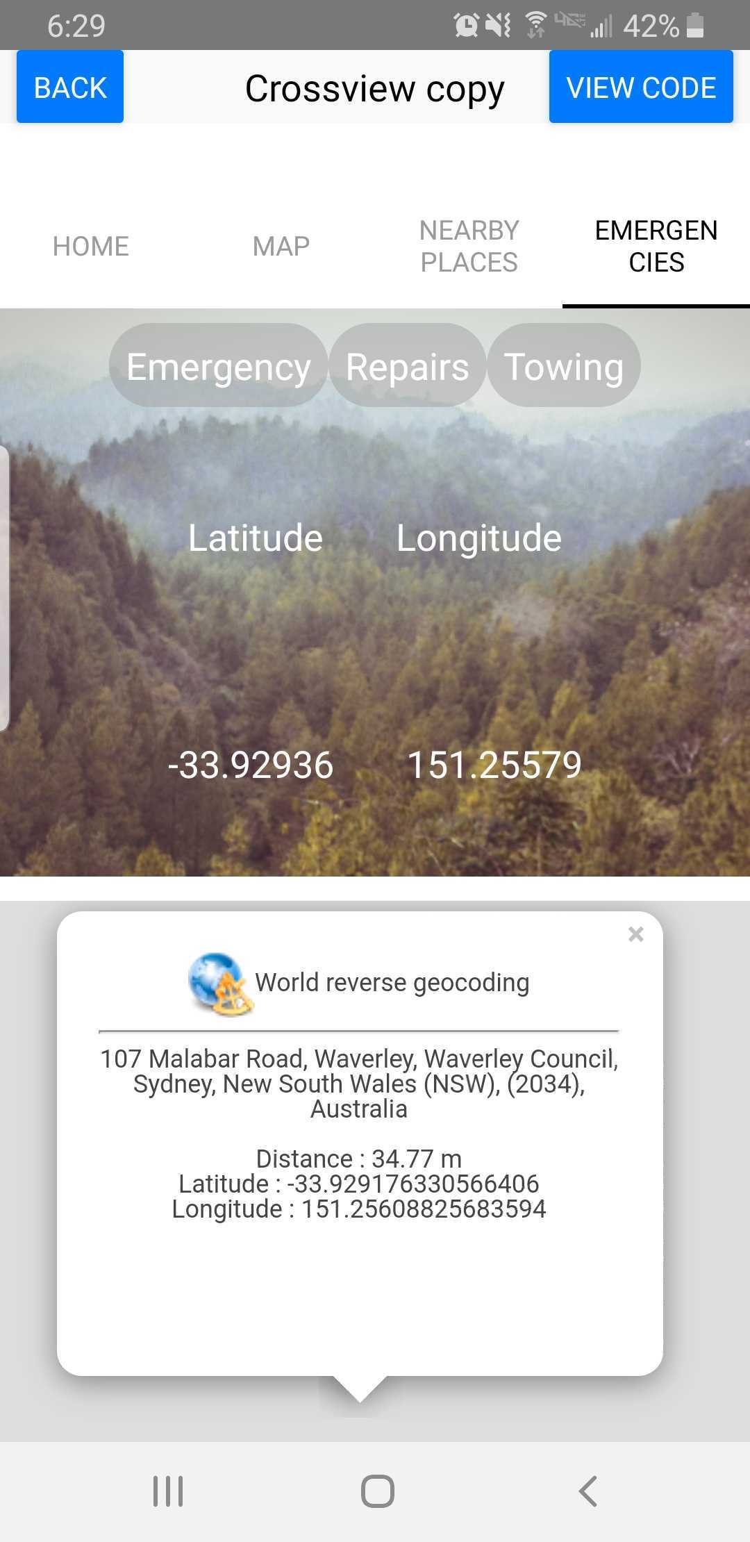
Where Am I? Automated Mapping provides relief from the inaccuracy of caller locations by utilizing pictures of their surroundings taken with their camera phone to pinpoint their location for first responders, roadside repair personnel, and towing facilities.
How we built it
- We used Putty to access the remote VPN needed for set up
- We used Thunkable to set up the front-end
- We used SSH, Anaconda, Python, JSON, Firebase, and a ubuntu server for the back-end
- We used Firebase to join the front-end and back-end together
- We used a CVM-NET neural network for the cross-view matching, which was the backbone to this entire project
Challenges we ran into
- We had problems setting up and accessing the VPN and ubuntu secure shell.
- We had some challenges using Thunkable, a drag and drop program, that has less versatility. Aminah found herself having to duplicate the ‘join’ block several times in order to concatenate a URL string with variables.
- There were also some logistical issues, in that there wasn’t enough time to figure out how to implement a reverse geolocation feature in the app to give users their address based on the found coordinates.
Accomplishments that we're proud of
- Learning and exploring new things, such as implementing machine learning, how to build a neural network, and using a remote server
- Finishing the project without rushing at the last minute
- That we were able to work together, create connections, and build something positive
What we learned
- Aminah: I learned from this project more about front-end development and how it connects to back-end development.
- My: I learned how to use Firebase and more about machine learning.
- Toni: I learned how to use my time more wisely, how to use a neural network, and how to use Putty to connect to a VPN.
What's next for Where Am I? Automated Mapping
- Implement a method to test viability of photos
- Improve upon the user experience
- Promote through partnerships with responders and through advertising
- Utilize an open-source or otherwise public API to be used to implement a reverse geolocation feature in the app to give its users their address based on the found coordinates
- Using an open-source solution to apply a Thunkable-external method that copies the address to the user’s clipboard for them to access later


Log in or sign up for Devpost to join the conversation.