-
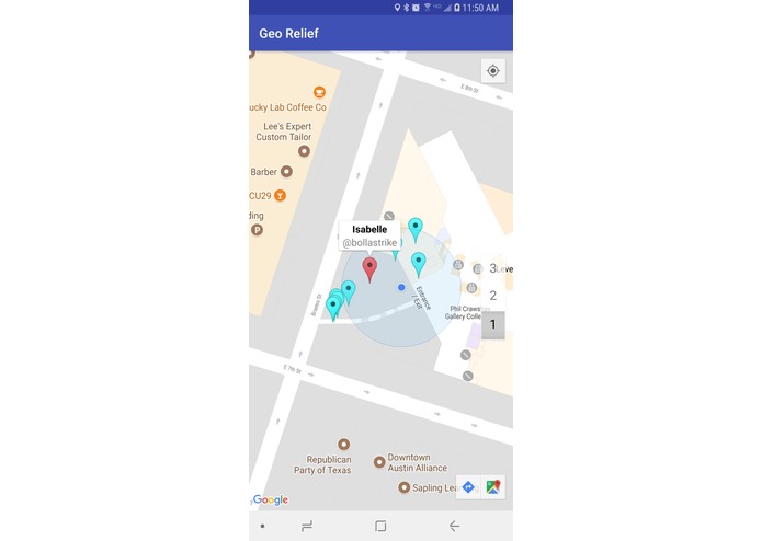
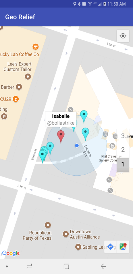
Quickly see people who need help, and who needs the most help based on color.
-
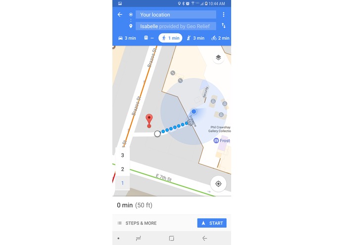
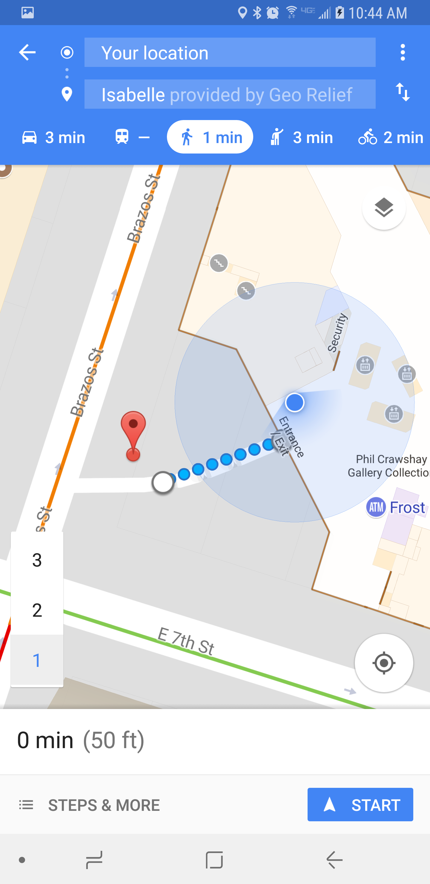
Directly go to Google Maps to get directions to the person in need.
Inspiration
In the wake of Hurricane Harvey and recent natural disasters, we decided there a need for better communication between first responders and people in emergency situations. Many people in need with Internet access are not able to reach out to nearby first responders. We realized that first responders needed to be better equipt with information to save people. The abundance of social media and the lack of communication lines between first responders and victims inspired GeoRelief to bridge that gap.
What it does
GeoRelief is able to inform first responders about the location and emergencies of people in need. This means that when normal rescue lines are strained, first responders are able to get to the people that still need help. We implemented a full vertical system that parses data through Twitter and send the relevant information about those that need aid. The information is sent to a server that we host, and from there, it is relayed to a mobile app that first responders would have access to. The app would communicate the locations and severity of the emergencies to first responders nearby.
How we built it
We built GeoRelief in several stages. First, we divided into back-end and front-end team. The back-end team developed a parsing program that would scan through Twitter for #georelief. The output would be the name, location (derived from the geocache of the tweets), and severity of the emergencies. From there, the parser would pass a text file to our local server. We pushed the parsing code into Flask, which was able to serve as an intermediary to the hosted server. The local server was hosted by Heroku, a web hosting service, using Github as the pipeline. This information was relayed as a url into our mobile app. The front-end team accepted the input from the hosted server into the client. From there, we parsed the data to make it into a JSON format, so our Android app could interact with it. We integrated the Google Maps API in order to construct a map with that data. The map on the app would plot the locations, and all the relevant information of the tweets from the people in emergencies. Finally, the UI allows any Android user with the app to determine the distance and severity of each emergency to respond to. The app would also return live feeds on who is in need of help real time.
Challenges we ran into
We ran into many, many problems. One of them included configuring a web server in order to relay the parsed data to the app. We tried several methods, but they ended up all not working. Firstly, we tried hosting via AWS, but we ran into some logistical problems that included the $100 credit not being redeemable, and some incompatibility with .utexas emails. We pivoted to using a web domain, through domain.com, however there were a lot of problems with the webpage. Our desired page kept returning DNS errors even though we published it, and then the domain.com platform had trouble converting the text file into HTML readable text. Then we hosted through Heroku under the guidance of a mentor, and that was what ended up working.
Accomplishments that we're proud of
We are very proud of GeoRelief, especially considering it was everyone’s first real hackathon. We were able to implement a full vertical system, and realized how challenging making front-end and back-ends are. Furthermore, communicating between the two was an even more difficult challenge. When the app finally worked, we were all very happy!
What we learned
GeoRelief taught us to be flexible in our approach. Even though our initial idea was not working well, we learned to pivot to other ideas and seek the help of mentors who could give us guidance. Our final product was through the concerted determination of all of our team, as well as the wisdom from the mentors here.
What's next for GeoRelief
GeoRelief was able to deliver a proof-of-concept that social media could very well make a difference in helping connect first responders to those in emergency. The next steps would be to make GeoRelief a universal tweet for first responders to identify. Ideally, everyone who needs help would know to tweet #georelief to reach out to first responders. Moreover, first responders would know to access the GeoRelief app to help those in need. Whether this is done through word-of-mouth, media circulation, or public service announcement, we know that GeoRelief will help those in need during disasters.


Log in or sign up for Devpost to join the conversation.